Hassanabad, Hunza

Last updated
Hassanabad, Hunza
Village
Hassanabad, Hunza.jpg
Hassanabad during Cherry blossom
Pakistan location map.svg
Red pog.svg
Hassanabad, Hunza
Location in Pakistan
Coordinates: 36°17′53″N74°35′42″E / 36.29806°N 74.59500°E / 36.29806; 74.59500
Country Flag of Pakistan.svg  Pakistan
Region Gilgit - Baltistan
Area
  Total2.1 km2 (0.8 sq mi)
Elevation
2,100 m (6,900 ft)

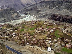
Hassanabad is one of the villages of the Hunza Valley. The Karakoram Highway (KKH) crawls through Hassanabad, with total length of 5 kilometers. [1] Hassanabad is known for power generation, with almost all of the hydro-power projects of Hunza located here, except for Ahmedabad Hydel Power Plant.

Contents

Location

Hassanabad is located in between Aliabad and Murtazaabad villages. [2] Hassanabad is located at an average height of 2100 meters. [3]

Hassanabad is located on the Karakoram Highway (N-35). In 2022, the bridge across a tributary of the Hunza was destroyed by floodwaters. [4]

Constituency

Hassanabad is in constituency of GBLA-6. Hassanabad comes in district Hunza and tehsil Aliabad.

Mountains

Hassanabad is also gateway to Hachinder Chish (7162.4 meters). [5] [6]

People

The population is of the town is around 1500 people. All of the residents are Muslims.

Tribes

Two of the old Hunza tribes are present in Hassanabad, Ganishkutz and Xhill Ganishkutz.

Notable People

Gems

Hassnabad nala is famous for different precious and semi-precious stones. Most common gems are Corundum, Diamond and Sapphire. [7] [8]

Hassanabad Power Complex

Gilgit-Baltistan Public works Department (GBPWD) manages Hassanabad Power Complex. Complex is a combination of Hydel and Thermal, Power generation plants.

Aerial View of Hassanabad Hassanabad, Hunza 2.jpg
Aerial View of Hassanabad

See also

Aliabad

Murtaazabad

Karimabad

Related Research Articles

<span class="mw-page-title-main">Gojal</span> Valley in Gilgit-Baltistan, Pakistan

Gojal, also called Upper Hunza, is situated in northwestern Pakistan. It borders China at the Khunjerab Pass, and Afghanistan at the Chapursan valley. In 2019, Gojal Valley became the second Karachukar sub-division within the Hunza District. It is geographically the largest subdivision of Gilgit-Baltistan.

<span class="mw-page-title-main">Hunza River</span> River in Pakistan

Hunza River is the principal river within the Hunza region in Gilgit–Baltistan, Pakistan. It is formed by the confluence of the Chapursan and Khunjerab nalas (gorges) which are fed by glaciers. It is also joined by the Gilgit River and the Naltar River, before it flows into the Indus River.

<span class="mw-page-title-main">Karakoram Highway</span> International highway running through Pakistan and China

The Karakoram Highway, also known as the KKH, National Highway 35, N-35, and the China–Pakistan Friendship Highway, is a 1,300 km (810 mi) national highway which extends from Hasan Abdal in the Punjab province of Pakistan to the Khunjerab Pass in Gilgit-Baltistan, where it crosses into China and becomes China National Highway 314. The highway connects the Pakistani provinces of Punjab and Khyber Pakhtunkhwa plus Gilgit-Baltistan with China's Xinjiang Uyghur Autonomous Region. The highway is a popular tourist attraction and is one of the highest paved roads in the world, passing through the Karakoram mountain range, at 36°51′00″N75°25′40″E at maximum elevation of 4,714 m (15,466 ft) near Khunjerab Pass. Due to its high elevation and the difficult conditions under which it was constructed, it is often referred to as the Eighth Wonder of the World. The highway is also a part of the Asian Highway AH4.

<span class="mw-page-title-main">Sust</span> Village in Gilgit-Baltistan, Pakistan

Sost or Sust is a village located in the Gojal, Upper Hunza in the Gilgit–Baltistan region of Pakistan. Situated at an elevation of 2,800 meters above sea level, Sost is the last Pakistani town on the Karakoram Highway before the Chinese border.

<span class="mw-page-title-main">Hunza Valley</span> Valley in Gilgit-Baltistan region of Pakistan

The Hunza Valley is a mountainous valley located in the northern region of the Gilgit-Baltistan, Pakistan.

<span class="mw-page-title-main">Nagar Valley</span> Valley in Gilgit Baltistan, Pakistan.

Nagar Valley once a princely state, now stands as one of the ten districts within the Gilgit-Baltistan region of Pakistan. This valley is situated along the renowned Karakoram Highway, as one travels northward from the city of Gilgit. The valley is home to many high mountain peaks including Rakaposhi (7788m), Diran Peak (7265m), Golden Peak and Rush Peak.

<span class="mw-page-title-main">Geography of Gilgit-Baltistan</span>

Gilgit-Baltistan is an administrative territory of Pakistan in the northern part of the country. It was given self-governing status on August 29, 2009. Gilgit-Baltistan comprises 14 districts within three divisions. The four districts of Skardu Kharmang Shigar and Ghanche are in the Baltistan Division, four districts of Gilgit Ghizer Hunza and Nagar districts which were carved out of Gilgit District are in the Gilgit Division and the third division is Diamir, comprising Chilas and Astore. The main political centres are the towns of Gilgit and Skardu.

<span class="mw-page-title-main">Raikot Bridge</span> Bridge in Diamer District, Pakistan

Raikot Bridge is a road bridge situated on the Karakoram Highway, spanning the River Indus. It is the gateway to Nanga Parbat base camp, in Diamer District, Gilgit Baltistan, Pakistan.

Juglot or Jaglot is a town located in the Gilgit District of Gilgit-Baltistan region in Pakistan. It is situated 45 kilometres (28 mi) southeast of the regional capital city of Gilgit on the Karakoram Highway. The town is situated at the junction of three major mountain ranges: the Karakoram, the Hindu Kush and the Himalayas. The confluence of the Gilgit and Indus river is also located nearby.

The Hunza–Nagar District is a former district of Gilgit–Baltistan in Pakistan. In July 2015, the district was divided into two separate districts, namely Hunza District and Nagar District.

<span class="mw-page-title-main">Aliabad, Hunza</span> Town in Gilgit–Baltistan, Pakistan

Aliabad is the administrative and commercial center of the Hunza District in Gilgit–Baltistan region of Pakistan.

Khizerabad is the first village in Hunza District of Gilgit-Baltistan, Pakistan.

Jafarabad is a town located in the Nagar District of Gilgit-Baltistan, Pakistan.

<span class="mw-page-title-main">Attabad Lake</span> Lake in Gilgit-Baltistan, Pakistan

Attabad Lake Gojal is a lake located in the Gojal region of Gilgit-Baltistan, Pakistan. It was formed in January 2010 when a significant landslide impounded the water the Hunza River in Attabad. The lake offers a diverse range of activities, from boating, jet-skiing, and fishing to various winter sports, attracting attention year-round.

<i>Safar Hai Shart</i> Pakistani TV series or programme

Safar Hai Shart is a travelogue television show on-air on Express News. The show was hosted by Waqar Ahmed Malik and Mukkaram Kaleem. Safar Hai Shart was an exclusive travelogue produced by Waqar Ahmed Malik, completed on nothing but motorbikes. Two guys on bikes explored the wonders of the Karakoram Highway in Pakistan. The Karakoram Highway (KKH) is the highest paved international road in the world and often known as 9th wonder of the world. The travels started from Rawalpindi and end on Khunjerab Pass, the highest paved international border crossing in the world and the highest point on the Karakoram Highway. The show comprises the adventure, thrill and depiction of native culture of Kohistan, Gilgit and Hunza. Safar Hai Shart also showed Nanga Parbat and the related expedition stories specially of Hermann Buhl, Reinhold Messner in 6th and 7th episodes. This program was produced with the cooperation of Frontier Works Organisation and World Wide Fund for Nature.

<span class="mw-page-title-main">Mayoon</span>

Mayoon or Maiun is a village and a small region of modern farms in the high mountainous Hunza area of northern Pakistan. It lies along one of the paths of the ancient Silk Road and has long been a trade crossroads for China, Afghanistan, India, and Pakistan. This has led to skirmishes and battles over the centuries.

<span class="mw-page-title-main">Sacred Rock of Hunza</span> A cultural heritage site in Gilgit-Baltistan, Pakistan

The Sacred Rocks of Hunza or Haldeikish constitute one of the earliest sites of Petroglyphs along the ancient Silk Route. It is a cultural heritage site in Gilgit-Baltistan region of northern Pakistan. The carvings on the rocks dates back to the 1st Millennium AD.

<span class="mw-page-title-main">Tourism in Gilgit-Baltistan</span>

Tourism in Gilgit-Baltistan, an administered territory of Pakistan, focuses on its access to various mountain ranges and alpine terrain. Various tourist destinations attract millions of travelers from within Pakistan. On the other hand, tourists from other countries also routinely visit GB. An estimated 1.72 million tourists visited the region in 2017 according to the Pakistan Tourism Development Corporation (PTDC). Travelers had contributed Rs.300 million to the local economy in 2017. The authorities were expecting 2.5 million tourists in 2018 which would have meant an additional Rs.450 million to the economy.

<span class="mw-page-title-main">Baba Jan (politician)</span> Left-wing politician from Hunza, Gilgit-Baltistan

Baba Jan is a left-wing political activist in the Gilgit-Baltistan territory administered by Pakistan. He was sentenced to 71 years in jail by the Gilgit-Baltistani courts on charges of terrorism and of inciting public against the state during the Aliabad incident. Jan was released from jail on November 27, 2020, after the Gilgit-Baltistani government agreed to release all the 14 people due to a week-long Aliabad sit by the families of the incarcerated. He was the former vice-president and now is the president of Awami Workers Party Gilgit Baltistan.

<span class="mw-page-title-main">Tatta Pani, Gilgit Baltistan</span> Village in Gilgit-Baltistan, Pakistan

Tatta Pani is a village of Diamer district, Gilgit-Baltistan, in Pakistan. It is notable due to the heavy landslides in the area and the worst part of Karakorum Highway.

References

  1. "PAMIR TIMES | Voices of the Mountain Communities – KKH damaged near Hasanabad, Hunza" . Retrieved 2016-07-21.
  2. "Hassan Abad - Wikimapia". wikimapia.org. Retrieved 2016-07-21.
  3. "Google Maps - Find GPS coordinates, longitude, latitude, altitude". www.mapcoordinates.net. Retrieved 2016-07-21.
  4. Pakistan: Bridge crumbles after heatwave triggers floods, BBC 10 May 2022
  5. "mountain-list". www.hunzaguidespakistan.com. Archived from the original on 2016-08-02. Retrieved 2016-07-21.
  6. "MASHABRUM EXPEDITIONS". www.mashabrum.com. Retrieved 2016-07-21.
  7. "Corundum Mineral Specimen For Sale". Pinterest. Retrieved 2016-07-21.
  8. "Hassanabad Nala (Hasanabad), Hunza Valley, Gilgit District, Gilgit-Baltistan (Northern Areas), Pakistan". www.mindat.org. Retrieved 2016-07-21.