Haughton, Staffordshire

Last updated
Haughton from the air Haughton20081116T142152.jpg
Haughton from the air
The local parish church The parish church of St. Giles', Haughton, Staffordshire(2).jpg
The local parish church
Newport Road through centre of Haughton Haughton Centre from Park Lane 20070602.jpg
Newport Road through centre of Haughton
The old Village School, Parish Church and Nation House Haughton Jolt Lane Junction 20070602.jpg
The old Village School, Parish Church and Nation House

Haughton is a village in Staffordshire, England, approximately 4 miles outside and to the west of the county town of Stafford. It lies on the A518 between Stafford and Gnosall. The name derives from a combination of the Mercian word halh meaning 'nook' and the Old English word tun meaning 'settlement', 'enclosure' or 'village.'

Contents

A small and peaceful rural village, Haughton contains 2 public houses, The Shropshire and The Bell. The population of the civil parish at the 2011 census was 1,082. [1] In the centre of the village situated on the main road is Haughton church, alongside which is the Old Village School (now a bed and breakfast). The new school is set back from the main road and caters for pupils between the ages of 5 and 11. The village offers a selection of shops: a recently refurbished and combined Post Office, General Store and Newsagents, hairdressers, and Fish & Chip shop and a farm shop. Red Lion Farm of Haughton is a local distributor of high quality ice-creams, which are widely recognised throughout the county. The ice-cream is produced fresh on-site by house-owned Jersey Cows, which inhabit the farm along with a number of other animals, including Alpacas. A caravan site is also situated on the farm premises, becoming very popular during early summer periods.

Haughton is widely known for its Christmas lights. Every year some of the village's most impressive houses have donation boxes outside them in order to raise money for charity. More information on this subject can be found on the Haughton home page, along with pictures of the most involved houses.

St. Giles church is in the centre of the village. And the nearby school often use the Church on religious occasions. The church is mainly 15th and 16th centuries, but religious activities date further back in the village.

Haughton in 1086

Haughton was recorded in the Domesday Book in 1086. [2] It was recorded as being in the hundred of Cuttlestone and the county of Staffordshire. According to the Domesday Book, Haughton boasted 14 households and was made up of 6 villagers, 7 smallholders and 1 slave. Annually the village was worth £1 and 10 shillings (30 shillings total) to its Lord; in modern terms this would be roughly £3,000 per year [3] - however it is worth noting that currency conversion is difficult to do over the course of over 900 years and that this value is not necessarily accurate.

Left hand side of the reredos, St Giles Church, Haughton Left hand side St Giles' Haughton Reredos.jpg
Left hand side of the reredos, St Giles Church, Haughton

Haughton in 1851

In 1851, Haughton had a railway station 1 mile north of the village, about 480 inhabitants and 2100 acres of land. The lord of the manor was Francis Eld, Esq of Seighford. The church, dedicated to St Giles, is built mostly of brick except the tower which is of stone. The Rector in 1851 was Rev Charles Smith Royds MA, whose rectory was built in 1804. The village has a National School, built in 1841 along with a house for the school master, the latter at the expense of the Rector. At that time, railway trains passed through the station 4 times a day each way on the line connecting Stafford and Shrewsbury.

Prominent people of the village included: Charles Morris, a gentleman, Thomas Deakin; tailor and Parish Clerk; William Wheat, gardener and victualler at the Shropshire House and Thomas Timmis, tailor and victualler at The Bell Inn. At that time the village had 3 wheelwrights, 3 shopkeepers, 19 farmers, 4 shoemakers, 2 blacksmiths, 3 butchers, and 2 beerhouses. Letters were collected in the evening at 5.30pm being taken via Stafford. [4]

Notable people

See also

Related Research Articles

<span class="mw-page-title-main">Tattenhall</span> Village in Cheshire, England

Tattenhall is a village and former civil parish, now in the parish of Tattenhall and District, 8 miles (13 km) south-east of Chester, in the unitary authority area of Cheshire West and Chester and the ceremonial county of Cheshire, England. In the 2001 census, the population was recorded as 1,986, increasing to 2,079 by the 2011 census.

<span class="mw-page-title-main">Woore</span> Human settlement in England

Woore is a village and civil parish in the north east of Shropshire, England, of about 3,950 acres. It had a population of 1,004 in the 2001 Census, rising to 1,069 at the 2011 Census.

<span class="mw-page-title-main">Sheriffhales</span> Human settlement in England

Sheriffhales is a scattered village in Shropshire, England, 4.3 miles (7 km) north-east of Telford, 2.5 miles (4 km) north of Shifnal and 4.3 miles (7 km) south of Newport. The name derives from Halh (Anglican) and scīr-rēfa which is a combination of Hales and Sheriff. At the time of the Domesday Book, it was held by Roger de Balliol the Sheriff of Shropshire.

<span class="mw-page-title-main">Gnosall</span> Human settlement in England

Gnosall is a village and civil parish in the Borough of Stafford, Staffordshire, England, with a population of 4,736 across 2,048 households. It lies on the A518, approximately halfway between the towns of Newport and the county town of Staffordshire, Stafford. Gnosall Heath lies immediately south-west of the main village, joined by Station Road and separated by Doley Brook. Other nearby villages include Woodseaves, Knightley, Cowley, Ranton, Church Eaton, Bromstead Heath, Moreton, and Haughton.

<span class="mw-page-title-main">Penn, West Midlands</span>

Penn is an area which is divided between the City of Wolverhampton and South Staffordshire district. The population of the Wolverhampton Ward taken at the 2011 census was 12,718. Originally, it was a village in the historic county of Staffordshire. There is considerable confusion about exactly which areas fall within Penn. In 19th century censuses, Merry Hill, Bradmore are understood to form part of Penn, although these areas are generally understood to be separate today. However, there has never been any doubt that the two historic settlements of Upper and Lower Penn form the core of the area.

<span class="mw-page-title-main">High Offley</span> Human settlement in England

High Offley is a small village and civil parish in Staffordshire, England. It lies 3 miles southwest of the small town of Eccleshall and about 1 mile west of the village of Woodseaves, both on the A519. Woodseaves is the largest settlement in the parish, which also includes the hamlet of Shebdon to the WSW of High Offley, as well as a number of scattered houses and small farms.
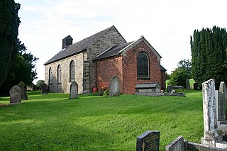
<span class="mw-page-title-main">Brewood</span> Human settlement in England

Brewood is an ancient market town in the civil parish of Brewood and Coven, in the South Staffordshire district, in the county of Staffordshire, England. Located around grid reference SJ883088, Brewood lies near the River Penk, eight miles north of Wolverhampton city centre and eleven miles south of the county town of Stafford. A few miles to the west of Brewood is the border with the county of Shropshire.

<span class="mw-page-title-main">Badger, Shropshire</span> Human settlement in England

Badger is a village and civil parish in Shropshire, England, about six miles north-east of Bridgnorth. The parish had a population of 134 according to the 2001 census, falling to 126 at the 2011 census.

<span class="mw-page-title-main">Seighford</span>

Seighford is a village and civil parish about 3 miles (5 km) west of Stafford in Staffordshire, England. The population of this civil parish at the 2011 census was 1,793. The ford across a small stream is the origin of the village's toponym. The village has a red brick Church of England parish church, St Chad's, and a 16th-century Tudor mansion.

<span class="mw-page-title-main">Totternhoe</span> Human settlement in England

Totternhoe is a village and civil parish in the Manshead hundred of the county of Bedfordshire, England.

<span class="mw-page-title-main">Tetsworth</span> Human settlement in England

Tetsworth is a village and civil parish about 3 miles (5 km) south of Thame in Oxfordshire. Its Parish Council is made up of six elected Councillors. The estimated population in 2018 was 752 persons. According to the Council, business included the Zioxi educational furniture plant, the Swan antiques centre and some nearby equestrian and agricultural enterprises. The village no longer had a post office or many retail operations, but retained its "church, primary school, village hall, sports on the village green, and village pub and restaurant".

<span class="mw-page-title-main">Church Minshull</span> Human settlement in England

Church Minshull is a village and civil parish in the unitary authority of Cheshire East and the ceremonial county of Cheshire, England. The village is approximately 5 miles (8.0 km) north west of Crewe, just west of the River Weaver and Shropshire Union Canal. The principal road through Church Minshull is the B5074 between Nantwich and Winsford. The modern village centre is a designated conservation area which contains many houses of Tudor style architecture. A large area in the east of the parish falls within the Weaver Valley Area of Special County Value.

<span class="mw-page-title-main">Trysull</span> Human settlement in England

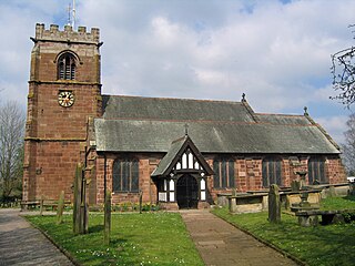
Trysull is a rural village in the county of Staffordshire, England approximately five miles south-west of Wolverhampton. With the adjacent village of Seisdon, it forms the civil parish of Trysull and Seisdon, within the South Staffordshire non-metropolitan district. Until 1974 it formed part of Seisdon Rural District. The 2011 census recorded a usually resident population for the parish of Trysull & Seisdon of 1,150 persons in 455 households.

<span class="mw-page-title-main">Smallburgh</span> Human settlement in England

Smallburgh is a village and a civil parish in the English county of Norfolk. The village is fourteen miles (21 km) south-east of Cromer, fourteen miles (21 km) north-east of Norwich and 132 miles (212 km) north-east of London. The village lies five miles (8 km) south-east of the nearby town of North Walsham. The nearest railway station is at Worstead for the Bittern Line which runs between Sheringham, Cromer and Norwich. The nearest airport is Norwich International Airport. At the 2001 census it had a population of 518 in 219 households. For the purposes of local government, it falls within the district of North Norfolk.

<span class="mw-page-title-main">Whitgreave</span> Human settlement in England

Whitgreave is a very small village a few miles to the NNW of Stafford situated midway between the M6 motorway to the west and the A34 trunk road to the east.

<span class="mw-page-title-main">Leigh, Staffordshire</span> Human settlement in England

Leigh is a civil parish in the English county of Staffordshire. The parish includes the village of Church Leigh, together with the settlements of Withington, Upper Leigh, Lower Leigh, Morrilow Heath, Middleton Green, Dodsley, Godstone, Nobut and Field.

<span class="mw-page-title-main">Weston, Staffordshire</span> Human settlement in England

Weston is a village and civil parish. within the English county of Staffordshire. The parish is in the local authority of Stafford.

<span class="mw-page-title-main">Hilderstone</span> Human settlement in England

Hilderstone is a village and a civil parish in the English county of Staffordshire.

<span class="mw-page-title-main">Little Birch</span> Human settlement in England

Little Birch is a hamlet and civil parish in Herefordshire, England. It is approximately 5 miles (8 km) south from the city and county town of Hereford and 7 miles (11 km) north-west from the market town of Ross-on-Wye. The parish is significant for its Grade II* listed church, and Athelstan Wood, formerly anciently managed but now largely coniferised.

<span class="mw-page-title-main">Marston, Milwich</span> Human settlement in England

Marston is a village and civil parish 12 miles (19 km) south of Stoke-on-Trent, in the Stafford district, in the county of Staffordshire, England. In 2011 the parish had a population of 158. The parish touches Creswell, Hopton and Coton, Salt and Enson, Sandon and Burston, Stone Rural and Whitgreave.

References

  1. "Civil Parish population 2011" . Retrieved 5 December 2015.
  2. "Doomsday Book".
  3. "Regia Anglorum".
  4. William White, History, Gazetteer and Directory of Staffordshire, 1851, p.462

52°46′55″N2°12′04″W / 52.782°N 2.201°W / 52.782; -2.201