
Cannock Chase, often referred to locally as The Chase, is a mixed area of countryside in the county of Staffordshire, England. The area has been designated as the Cannock Chase Area of Outstanding Natural Beauty and is managed by Forestry England. The Chase gives its name to the Cannock Chase local government district. It is a former Royal forest.

Cannock is a town in the Cannock Chase district in the county of Staffordshire, England. It had a population of 29,018. Cannock is not far from the towns of Walsall, Burntwood, Stafford and Telford. The cities of Lichfield and Wolverhampton are also nearby.

Rugeley is a market town and civil parish in the Cannock Chase District, in Staffordshire, England. It lies on the north-eastern edge of Cannock Chase next to the River Trent; it is situated 8 miles (13 km) north of Lichfield, 10 miles (16 km) south-east of Stafford, 5 miles (8.0 km) north-east of Hednesford and 11 miles (18 km) south-west of Uttoxeter. At the 2021 Census, the population was 26,156.
The Borough of Stafford is a local government district with borough status in Staffordshire, England. It is named after Stafford, its largest town, which is where the council is based. The borough also includes the towns of Stone and Eccleshall, as well as numerous villages and surrounding rural areas.
South Staffordshire is a local government district in Staffordshire, England. Its council is based in Codsall. Other notable settlements include Brewood, Cheslyn Hay, Coven, Essington, Featherstone, Four Ashes, Great Wyrley, Huntington, Kinver, Landywood, Penkridge, Perton, Wedge Mills, Weston-under-Lizard and Wombourne. The district covers a largely rural area lying immediately to the west and north-west of the West Midlands conurbation.
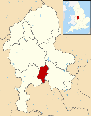
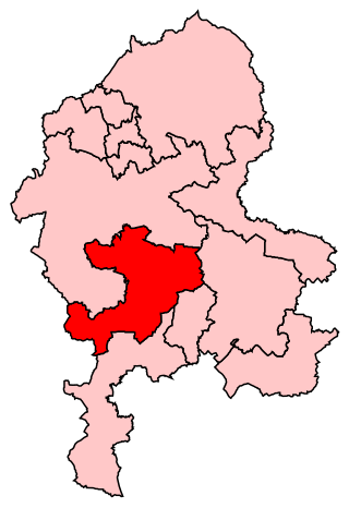
Cannock Chase is a local government district in Staffordshire, England. It is named after and covers a large part of Cannock Chase, a designated Area of Outstanding Natural Beauty. The council is based in the town of Cannock. The district also contains the towns of Hednesford and Rugeley, as well as a number of villages and surrounding rural areas.

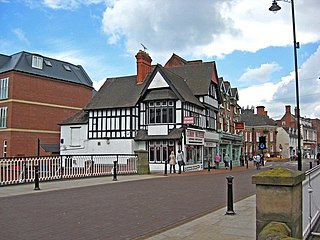
Hednesford is a market town and civil parish in the Cannock Chase district of Staffordshire, England. The Cannock Chase area of natural beauty is to the north of the town. Hednesford is also 1 mile (1.6 km) to the north of Cannock and 5 miles (8.0 km) to the south of Rugeley. The population at the 2011 census was 17,343.
Hixon is a village and a civil parish in the English county of Staffordshire.
grid reference SK003259
Stafford is a constituency represented in the House of Commons of the UK Parliament since 2019 by Theodora Clarke, a Conservative.
Brindley Heath is an area of heath land on Cannock Chase situated between Hednesford and Rugeley in the Cannock Chase District of Staffordshire, England. The area also forms a civil parish, which at the 2001 census, had a population of 862, decreasing to 827 at the 2011 Census.
Great Haywood is a village in central Staffordshire, England, just off the A51 and about 4.5 miles (7.2 km) northwest of Rugeley and 7.1 miles (11.4 km) southeast of the county town of Stafford. Population details taken at the 2011 census can be found under Colwich.
Milford is a village in the county of Staffordshire, England. It lies at the edge of Cannock Chase, on the A513 road between Stafford and Rugeley. Just to the north of the village is the River Sow.

Brocton Football Club is a football club representing Brocton, near Stafford, England. They are currently members of the Midland League Premier Division and play at Silkmore Lane in Stafford.
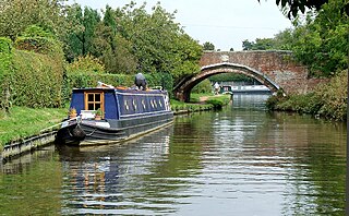
Little Haywood is a village in Staffordshire, England. For population details as taken at the 2011 census see under Colwich. It lies beside a main arterial highway, the A51 but traffic through the village is mainly light, owing to this bypass. Nearby also is the West Coast Main Line railway, the Trent and Mersey Canal and beside it, the river Trent. Little Haywood is about 125 miles (201 km) northwest of London, about 25 miles (40 km) north of Birmingham, 4 miles (6.4 km) northwest of Rugeley and 6 miles (9.7 km) east of Stafford.

The New Zealand Rifle Brigade (Earl of Liverpool's Own), affectionately known as The Dinks, was formed on 1 May 1915 as the third brigade of the New Zealand Division, part of the New Zealand Expeditionary Force. During the First World War it fought in Egypt, against the Senussi, and then on the Western Front. It was disbanded on 4 February 1919.

The Cannock Chase German Military Cemetery is on Cannock Chase, Staffordshire, England. The cemetery contains nearly 5,000 burials from both the First and Second World War. The burials are mainly German and Austrian nationals with a very small number of Ukrainians.
Royal Air Force Hednesford or more simply RAF Hednesford is a former Royal Air Force station situated 7.5 miles (12.1 km) south-east of Stafford, Staffordshire, England.

Brocton Hall is a building of historical significance and is listed on the English Heritage Register. It was built in 1760 by William Chetwynd and remained in the Chetwynd family until 1923 when it was sold to the Golf Club. Today the building is still used as a clubhouse and is also a venue for weddings.
Kingstone is a village and civil parish within the English county of Staffordshire.
Brocton is a civil parish in the Borough of Stafford, Staffordshire, England. It contains eight listed buildings that are recorded in the National Heritage List for England. All the listed buildings are designated at Grade II, the lowest of the three grades, which is applied to "buildings of national importance and special interest". The parish contains the village of Brocton and the surrounding area. The listed buildings consist of houses and cottages in the village, a country house and items in its grounds, and a military cemetery.

