
Croxden is a village in the county of Staffordshire, England, south of Alton and north of Uttoxeter. The population of the civil parish as taken at the 2011 census was 255.

Norbury is a village and civil parish in the Borough of Stafford, in west Staffordshire, England. The population as taken at the 2011 census was 371.

Haughton is a village in Staffordshire, England, approximately 4 miles outside and to the west of the county town of Stafford. It lies on the A518 between Stafford and Gnosall. The name derives from a combination of the Mercian word halh meaning 'nook' and the Old English word tun meaning 'settlement', 'enclosure' or 'village.'
Acton Trussell and Bednall is a civil parish in the South Staffordshire district of Staffordshire, England. As the name indicates, it contains the two villages Acton Trussell, Bednall. Teddesley Hay is part of the grouped parish council. The population of the civil parish at the 2011 census was 1,248.
Waterhouses is a village in the south of the Staffordshire Peak District in England. It is around 8 miles from Leek and Ashbourne, being nearly the halfway point between the two towns on the A523 road, which roughly follows the southern boundary of the Peak District National Park. Waterhouses is also a civil parish, created in 1934 when the parishes of Calton, Cauldon, Waterfall and part of Ilam were merged; previously the village of Waterhouses was on the boundary of Waterfall and Cauldon parishes. The hamlet of Winkhill is also in the parish. The population of the civil parish at the 2011 census was 1,134.
Anglesey is a civil parish in the East Staffordshire district of Staffordshire, England. It covers an area in the south of Burton upon Trent, south of the town centre, around Anglesey Road. According to the 2001 census it had a population of 5,835, increasing to 6,809 at the 2011 census.
Berkswich is a civil parish in the borough of Stafford in Staffordshire, England. According to the 2001 census it had a population of 1,528, being recalculated as 2,010 at the 2011 Census.
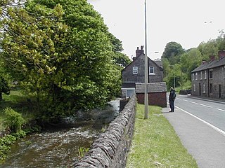
Seighford is a village and civil parish about 3 miles (5 km) west of Stafford in Staffordshire, England. The population of this civil parish at the 2011 census was 1,793. The ford across a small stream is the origin of the village's toponym. The village has a red brick Church of England parish church, St Chad's, and a 16th-century Tudor mansion.

Caverswall is a village and parish in Staffordshire, to the south west of Staffordshire Moorlands.

Kingsley is a small village in the Staffordshire Moorlands near to Cheadle, and situated on the A52 from Stoke on Trent to Ashbourne. The civil parish population taken at the 2011 census was 2,204.

Ellenhall is a small Staffordshire village roughly 2.5 miles south of Eccleshall originally comprising part of the extensive estates of the Earl of Lichfield. The population as taken at the 2011 census was 144. The village consists of a scattered community of cottages, a hall, and several farms. Ellenhall has no shop, public house or post office.
Chebsey is a small village in Staffordshire 2.5 miles southeast of Eccleshall on a confluence of Eccleshall water and the River Sow some 5 miles northwest of Stafford. The population of the civil parish at the 2011 census was 566. It comprises a number of houses and cottages and a village church dedicated to All Saints.

Church Eaton is a village and civil parish in Staffordshire some 6 miles (10 km) southwest of Stafford, 6 miles (10 km) northwest of Penkridge and 4 miles (6 km) from the county boundary with Shropshire. It is in rolling dairy farming countryside. The hamlet of Wood Eaton is northwest of the village.
Chilcote is a village and civil parish in the North West Leicestershire district of Leicestershire, England. Until 1897 it was in Derbyshire. The parish had a population of 108 according to the 2001 census, including Stretton-en-le-Field and increasing to 200 at the 2011 census.

Forton is a small village and civil parish in Staffordshire, England, situated east of the market town of Newport, Shropshire. The civil Parish population at the 2011 census was 308.

Hollington is a village in the Staffordshire Moorlands in English county of Staffordshire. There are several villages of this same name, and there is a Hollington, Derbyshire a few miles to the east in Derbyshire. The population taken at the 2011 census was 212.
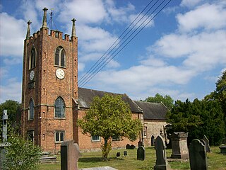
Shareshill is a village and civil parish in the South Staffordshire district, in the county of Staffordshire, England. The population as measured in the 2011 census was 759. The parish church is dedicated to St Mary and St Luke, Shareshill.

Lapley, Stretton and Wheaton Aston is a civil parish in South Staffordshire, England. The population of the civil parish at the 2011 census was 2,548.

Trysull and Seisdon is a conjoined civil parish in the South Staffordshire non-metropolitan district, in the county of Staffordshire, England. The population of the civil parish taken at the 2011 census was 1,150. It is in the lowest tier of local government below districts and counties. It is both an administrative parish, and an ecclesiastical parish formed from the two historic villages of Trysull and Seisdon.

Hyde Lea is a village and parish in Staffordshire, England, just west of Stafford itself.
