Hazelridge

Last updated
Hazelridge
Unincorporated community
Hazelridge Manitoba Sign.jpg
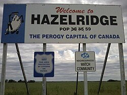
The sign claiming Hazelridge as the perogy capital of Canada
Canada Manitoba location map 2.svg
Red pog.svg
Hazelridge
Coordinates: 49°57′54″N96°43′01″W / 49.965°N 96.717°W / 49.965; -96.717 Coordinates: 49°57′54″N96°43′01″W / 49.965°N 96.717°W / 49.965; -96.717
Area codes 204, 431

Hazelridge is a community in the Rural Municipality of Springfield, Manitoba.

Services available in Hazelridge include an elementary school [1] and a sports complex. [2] Hazelridge is located adjacent to the Heartland Hutterite Colony. Hazelridge is the self-proclaimed "Perogy capital of Canada" as stated on a large sign at the entrance to the community.

History

It is first noted as a Post Office in 1904 and located on NW 25-11-6E.. It moved to 33-11-6E near the CPR station which was built in 1907. The Post Office took the name of Klondyke in 1909 and closed in 1915. At some point the present name took common usage although there was a Hazelridge and a Klondike school district mentioned in records.

Related Research Articles

University of Manitoba University in Winnipeg, Manitoba, Canada

The University of Manitoba is a Canadian public research university in the province of Manitoba. Founded in 1877, it is the first university of western Canada.

The Pas Town in Manitoba, Canada

The Pas is a town in Manitoba, Canada, located at the confluence of the Pasquia River and the Saskatchewan River and surrounded by the unorganized Northern Region of the province. It is approximately 630 km (390 mi) northwest of the provincial capital, Winnipeg, and 40 km (25 mi) from the border of Saskatchewan. It is sometimes still called Paskoyac by locals after the first trading post, called Fort Paskoya and constructed during French colonial rule. The Pasquia River begins in the Pasquia Hills in east central Saskatchewan. The French in 1795 knew the river as Basquiau.

Bell MTS Inc. is a subsidiary of BCE Inc. that operates telecommunications services in Manitoba. Bell MTS is the naming rights holder of a venue in Winnipeg, the Bell MTS Iceplex.

Brandon University University in Brandon, Canada

Brandon University is a university located in the city of Brandon, Manitoba, Canada, with an enrollment of 3375 (2020) full-time and part-time undergraduate and graduate students. The current location was founded on July 13, 1899, as Brandon College as a Baptist institution. It was chartered as a university by then President John E. Robbins on June 5, 1967. The enabling legislation is the Brandon University Act. Brandon University is one of several predominantly undergraduate liberal arts and sciences institutions in Canada.

Deloraine, Manitoba Place in Manitoba, Canada

Deloraine is an unincorporated urban community in the Municipality of Deloraine – Winchester within the Canadian province of Manitoba that held town status prior to January 1, 2015. It is situated near the Turtle Mountains in the southwestern corner of the province. Located in the Westman Region, the community is 100 kilometres south of Brandon. Deloraine originally incorporated as a village in 1904 and then as a town in 1907. Its town status was relinquished in 2015 when it amalgamated with the Rural Municipality of Winchester.

Winkler, Manitoba City in Manitoba, Canada

Winkler is a city in Manitoba, Canada with a population of 13,745, making it the 4th largest city in Manitoba, as of the 2021 Canadian census. It is located in southern Manitoba, surrounded by the Rural Municipality of Stanley, about one hundred kilometres southwest of Winnipeg and thirteen kilometres east of Morden. As the largest city in the Pembina Valley, it serves as a regional hub for commerce, agriculture and industry.

Boissevain, Manitoba Population centre in Manitoba, Canada

Boissevain is an unincorporated urban community in Manitoba near the North Dakota border that held town status prior to 2015. It is located within the Municipality of Boissevain – Morton. Boissevain is a community of just over 1,500 people and it is between Killarney and Deloraine on the east and west with Brandon in the north. The population of the surrounding area, within a 50 kilometre radius of the community, is about 15,000.

Transcona, Winnipeg Suburb of Winnipeg

Transcona is a ward and suburb of Winnipeg, Manitoba, located about 10 kilometres (6.2 mi) east of the downtown area.

Emerson, Manitoba Local urban district in Manitoba, Canada

Emerson is an unincorporated community recognized as a local urban district in south central Manitoba, Canada, located within the Municipality of Emerson – Franklin. It has a population of 678 as of the 2016 Canada census.

Stonewall, Manitoba Town in Manitoba, Canada

Stonewall is a town in the Canadian province of Manitoba with a population of 5,046 as of the 2021 census. The town is situated approximately 25 kilometres (16 mi) north of Winnipeg on PTH 67. It is known for its limestone quarries. The local festival is the Quarry Days which is usually held over three days in August on Main Street. The town is surrounded by the R.M. of Rockwood.

Rural Municipality of Springfield Rural municipality in Manitoba, Canada

Springfield is a rural municipality (RM) in Manitoba, Canada. It stretches from urban industrial development on the eastern boundary of the City of Winnipeg, through urban, rural residential, agricultural and natural landscapes, to the Agassiz Provincial Forest on the municipality's eastern boundary. Birds Hill Provincial Park nestles into the northwestern corner of Springfield.

Badger, Manitoba is a hamlet in the Rural Municipality of Piney, Manitoba. The community, whose elevation is 377 m (1,236 ft), lies southwest of Whitemouth Lake, and is surrounded by the Sandilands Provincial Forest.

St. Adolphe, Manitoba Place in Manitoba, Canada

St. Adolphe, or Saint Adolphe, originally called Pointe-Coupée, is a community in the Rural Municipality of Ritchot, Manitoba, Canada. It is located along the east bank of the Red River, approximately 12 kilometres south of Winnipeg.

Langenburg, Saskatchewan Town in Saskatchewan, Canada

Langenburg is a town in the rural municipality of Langenburg No. 181, located within the Saskatchewan Association of Rural Municipalities SARM Division No. 1 and Census Division No. 5, in the Canadian province of Saskatchewan.

Anola Place in Manitoba, Canada

Anola is an unincorporated community in the Canadian province of Manitoba. It is located 24 kilometres east of Winnipeg and 40 kilometres north of Steinbach in the Rural Municipality of Springfield. The community has a population of approximately 200 people.

Waskada Former village in Manitoba, Canada

Waskada is an unincorporated urban community in the Municipality of Brenda – Waskada within the Canadian province of Manitoba that held village status prior to January 1, 2015. It is located in the southwest corner of the province, close to the United States and Saskatchewan borders. It was settled as early as 1883 and incorporated as a village in 1948. Waskada has a population of 183, and covers a land area of 0.77 km2. Though traditionally a farming community, a recent oil boom has also brought economic activity to the area.

Gainsborough, Saskatchewan Village in Saskatchewan, Canada

Gainsborough is a village in the Canadian province of Saskatchewan within the Rural Municipality of Argyle No. 1 and Census Division No. 1. A farming community, the village is located on Highway 18 in the southeastern corner of Saskatchewan. Gainsborough is approximately 6 km (3.7 mi) from the Manitoba border, and 19 km (12 mi) from the North Dakota, United States border. The first post office was established on April 1, 1884 as the community of Antler. On September 1, 1885 the name of the community changed to Gainsborough, after Gainsborough, Lincolnshire in England, which was the former home of J. J. Sadler, an early settler.

Prawda, Manitoba Hamlet in Manitoba

Prawda is an unincorporated community in the Rural Municipality of Reynolds, situated a few miles east of Hadashville on the Trans Canada Highway in eastern Manitoba. The population of this community is 200. The community's amenities include two service stations/convenience store & restaurants and a campground (Pinetree).

Arrow River, Manitoba Place in Manitoba, Canada

Arrow River is an unincorporated community in southwestern Manitoba, Canada. It is located approximately 10 kilometers east of Miniota, Manitoba in the Prairie View Municipality.

Randolph, Manitoba Place in Manitoba, Canada

Randolph, originally known as Chortitz, is a small community in the Rural Municipality of Hanover, Manitoba, Canada. The community has an estimated population of 70 and is located 1.6 kilometres north of Highway 52 on Provincial Road 206 about 11 kilometres east of Steinbach. Randolph is located within a half kilometre of the longitudinal centre of Canada.

References

  1. "Hazelridge School - Sunrise School Division". hazelridge.sunrisesd.ca/. Retrieved November 23, 2019.{{cite web}}: CS1 maint: url-status (link)
  2. "Home". Hazelridge Sports Complex. Retrieved 2019-11-24.