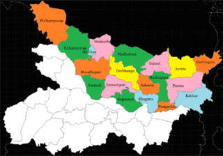
Vaishali district is a district in the Indian state of Bihar. It is a part of Tirhut division. Vaishali is known for being the birthplace of Mahavira of the Jain religion. Hajipur, its largest city and district headquarters, is known for its banana forest. The district is connected via the NH-77 and NH-322 highways, Gandhi Setu and Jay Prakash Setu Bridges over(Holy) Ganga River which connect the state capital Patna, the division headquarters Muzaffarpur, and the eastward district Samastipur.

Munger, formerly spelt as Monghyr, is a twin city and a Municipal Corporation situated in the Indian state of Bihar. It is the administrative headquarters of Munger district and Munger Division. Munger was one of the major cities in Eastern India and undivided Bengal during Mughal period and British Raj. It is one of the major political, cultural, educational and commercial center of Bihar and Eastern India. Munger is situated about 180km from east of capital city Patna, about 480km west of Eastern India's largest city Kolkata and 1200km from country's capital New Delhi.

Purnia is the fourth largest city of Bihar and is emerging as the largest economic hub in North Bihar. It serves as the administrative headquarters of both Purnia district and Purnia division in the Indian state of Bihar. It is well known for its favourable climate like Darjeeling and has an abundance of resources for human settlements and economic activities.

Hajipur is the headquarters and largest city of Vaishali district of the state of Bihar in India. Hajipur is the 16th most populous city of Bihar, besides being the second-fastest developing city, next to Patna. It had a total population of 1.47 lakh as per census 2011. Vaishali district is ranked 8th among 38 districts in Bihar in terms of growth.

The East Central Railway is one of the 19 railway zones in India. It is headquartered at Hajipur and comprises Sonpur, Samastipur, Danapur, Pt. Deen Dayal Upadhyaya and Dhanbad divisions.

Raxaul is a sub-divisional town in the East Champaran district of the Indian state of Bihar. It is situated at the India-Nepal border with Birgunj city (Nepal). Raxaul is a major railway junction.

Barauni is an industrial town situated on the bank of the river Ganges in the Begusarai district in the state of Bihar, India. It lies north of the Ganges (Ganga) River.
Mohania is a city and corresponding community development block in Kaimur district of Bihar, India. It serves as headquarters for the Mohania sub-division in Kaimur district. It is 17 km (11 mi) by road north of the city of Bhabua, at the intersection of National Highway 19, NH-219, and NH-319. The bank of the Durgavati River is just to the south of Mohania. The total block population was 218,479, in 32,198 households.

Govindpur Jhakhraha is a small village in the historical Vaishali district of Bihar, India. It is located across NH 322 at 13 km east of district headquarters Hajipur. The village falls under Bakarpur Panchayat of Rajapakar community development block. The population of the village is approximately 1800. Bajjika is the main dialect but Hindi and Urdu is the medium of study. English is understood and spoken by a few elites of the village.

North Bihar is a term used for the region of Bihar, India, which lies north of the Ganga river.
Bihta is a town and Block under Danapur Tehsil in Patna district in the Indian state of Bihar. Bihta is part of Maner assembly constituency under the Pataliputra Lok Sabha. It is located around 30 km (19 mi) west of Patna. Bihta is also an upcoming satellite town of Patna. The IIT Patna is around 3.5 km (2.2 mi) from Bihta railway station.
Umaidpur is one of the villages of Morwa Dakshni Gram panchayat in Morwa in the Samastipur District of Bihar State, India.
The state of Bihar has a number of bridges, extending from few metres to a few kilometres. The history of long bridges goes back to the British Empire when the site for the Koilwar bridge was surveyed in 1851. Since then a number of small and large bridges have crept up. Some are even largest of their kind. Mahatma Gandhi Setu, joining Patna and Hajipur was India's longest river bridge from 1982 to 2017.
Andharwara is a village in Vaishali district of the Indian state of Bihar. The panchayat offices are located at Panchayat bhawan in Baranti. Hajipur is the closest town, at a 10-11 kilometre distance, and closest station Akshywat Rai Nagar Near Suresh Prasad Chowk Bidupur RS NH 322(National highway 322) is the closest highway.

Jandaha is a block in Vaishali district, Bihar state, According to the census website, all blocks in Bihar state nomenclature as C.D. Block.
Chandih is a village in Bahadurpur Block, Darbhanga District, Mithila, Bihar, India.
The Kacchi Dargah–Bidupur Bridge, currently under construction, will span the river Ganges, connecting Kacchi Dargah in Patna and Bidupur in Hajipur in the Indian state of Bihar. Upon completion in 2025, the bridge will provide an easy roadway link between the northern and southern parts of Bihar and will connect two major national highways, linking NH 31 to NH 322.
National Highway 322 is a National Highway in India. This highway runs entirely in the state of Bihar. This highway provide connection between NH-22 at Hajipur in Vaishali district and NH-122 at Musrigharari in Samastipur district.
Raghopur Narsanda is a village in the Vaishali district of Bihar, India, in Patepur Block. It is 60 km from the main local city of Patna, and 40 km from its district headquarters of Hajipur. Its nearest towns are Muzaffarpur Patepur, Chehrakala, Jandaha, Samastipur Mahnar, Garaul and Tajpur.
Pokhraira is a village in Bokhra block of Sitamarhi District in Bihar state of India. It is surrounded by three main cities of Bihar, which are Muzaffarpur, Darbhanga and Sitamarhi. Pokhraira is 27 km distance from district main city Sitamarhi and 97 km distance from state capital Patna.


