
The Sawtooth National Recreation Area (SNRA) is a national recreation area in central Idaho, United States that is managed as part of Sawtooth National Forest. The recreation area, established on August 22, 1972, is managed by the U.S. Forest Service, and includes the Sawtooth, Hemingway–Boulders, and Cecil D. Andrus–White Clouds wilderness areas. Activities within the 730,864-acre (2,957.70 km2) recreation area include hiking, backpacking, White water rafting, camping, rock climbing, kayaking, mountain biking, fishing, and hunting.

The Sawtooth Range is a mountain range of the Rocky Mountains in central Idaho, United States, reaching a maximum elevation of 10,751 feet (3,277 m) at the summit of Thompson Peak. It encompasses an area of 678 square miles (1,756 km2) spanning parts of Custer, Boise, Blaine, and Elmore counties, and is bordered to the east by the Sawtooth Valley. Much of the mountain range is within the Sawtooth Wilderness, part of the Sawtooth National Recreation Area and Sawtooth National Forest.

Thompson Peak, at 10,751 feet (3,277 m) above sea level is the highest peak in the Sawtooth Range of Idaho. The summit of Thompson Peak is located within Custer County, although some of the lower portion of the mountain is in Boise County. Thompson Peak is also located within the Sawtooth Wilderness portion of the Sawtooth National Recreation Area, a unit of Sawtooth National Forest. The town of Stanley, Idaho is about 6 miles (9.7 km) northeast of Thompson Peak.

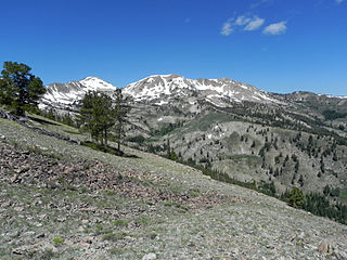
Castle Peak is a mountain in the western United States, the highest peak in the White Cloud Mountains of central Idaho and the Idaho Batholith. Located in Custer County, it is the 25th highest peak in the state, and the ninth most prominent.
Heart Lake is a small alpine lake in Elmore County, Idaho, United States, located in the Sawtooth Mountains in the Sawtooth National Recreation Area. The lake is accessed from Sawtooth National Forest trail 461.

The Soldier Mountains are a mountain range in the U.S. state of Idaho, spanning northern Camas and eastern Elmore counties. The highest point in the range is Smoky Dome at 10,095 feet (3,077 m), and the range is bounded on the west and north by the South Fork Boise River. The mountains are located within Sawtooth National Forest north of Fairfield, Idaho. The Soldier Mountain Ski Area is located within the range to the east of Smoky Dome.
Smoky Dome, at 10,095 feet (3,077 m) above sea level is the highest peak in the Soldier Mountains of Idaho. Smoky Dome is located northwest of Fairfield in Camas County and Sawtooth National Forest.

The Smoky Mountains are part of the Rocky Mountains and located on the west side of the Wood River Valley near Sun Valley, Idaho, in the Western United States. The range is within Sawtooth National Forest, while part of it is within the Sawtooth National Recreation Area. The highest point in the range is Saviers Peak at 10,441 ft (3,182 m).
Heart Lake is an alpine lake in Custer County, Idaho, United States, located in the White Cloud Mountains in the Sawtooth National Recreation Area. No trail lead to the lake, but it is most easily accessed from Sawtooth National Forest road 209.
Lower Deadwood Lake is an alpine lake in Camas County, Idaho, United States, located in the Soldier Mountains in the Sawtooth National Forest. While no trails lead to the lake, the lake is east of Iron Mountain, which has an old Forest Service lookout on the top.
Upper Deadwood Lake is an alpine lake in Camas County, Idaho, United States, located in the Soldier Mountains in the Sawtooth National Forest. While no trails lead to the lake, the lake is east of Iron Mountain, which has an old Forest Service lookout on the top.
Boardman Lake is an alpine lake in Camas County, Idaho, United States, located in the Soldier Mountains in the Sawtooth National Forest. While no trails lead to the lake, it can be most easily accessed from trail 091. The lake is north of Boardman Peak.
Lower Smoky Dome Lake is an alpine lake in Camas County, Idaho, United States, located in the Soldier Mountains in the Sawtooth National Forest. No trails lead to the lake, and it is in the Smoky Dome Lakes basin northeast of Smoky Dome, which is the highest peak in the Soldier Mountains.
Upper Smoky Dome Lake 2 is an alpine lake in Camas County, Idaho, United States, located in the Soldier Mountains in the Sawtooth National Forest. No trails lead to the lake, and it is in the Smoky Dome Lakes basin northeast of Smoky Dome, which is the highest peak in the Soldier Mountains.
West Smoky Dome Lake is an alpine lake in Camas County, Idaho, United States, located in the Soldier Mountains in the Sawtooth National Forest. No trails lead to the lake, and it is in the Smoky Dome Lakes basin northeast of Smoky Dome, which is the highest peak in the Soldier Mountains.
Upper Smoky Dome Lake 1 is an alpine lake in Camas County, Idaho, United States, located in the Soldier Mountains in the Sawtooth National Forest. No trails lead to the lake, and it is in the Smoky Dome Lakes basin northeast of Smoky Dome, which is the highest peak in the Soldier Mountains.
Boardman Creek is a stream in the Sawtooth National Forest in Camas County, Idaho in the United States. It is a tributary of the South Fork Boise River, which in turn is a tributary to the Snake River and Columbia River.
Deadwood Creek is a stream in the Sawtooth National Forest in Camas County, Idaho in the United States. It is a tributary of the South Fork Boise River, which in turn is a tributary to the Snake River and Columbia River.

Iron Mountain, at 9,694 feet (2,955 m) high is one of the peaks of the Soldier Mountains of Idaho. Iron Mountain is located at the west end of the range northwest of Fairfield in Camas County and Sawtooth National Forest.
Boardman Peak, at 9,457 feet (2,882 m) high is one of the peaks of the Soldier Mountains of Idaho. Boardman Peak is located at the center of the range southeast of Iron Mountain, northwest of Smoky Dome, and northwest of Fairfield in Camas County and Sawtooth National Forest. No trails go to the summit, but several pass near the peak, and the ascent is only class 2.

