
Kaitoke, part of Upper Hutt City, is a locality in the southern North Island of New Zealand. It is located at the northern end of the Hutt Valley, 45 kilometres northeast of Wellington City and six kilometres from the northern end of the Upper Hutt urban area. It also lies at the southern end of the Tararua Ranges.
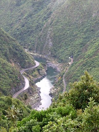
The Manawatū Gorge is a steep-sided gorge formed by the Manawatū River in the North Island of New Zealand. At 6 km (3.7 mi) long, the Manawatū Gorge divides the Ruahine and Tararua Ranges, linking the Manawatū and Tararua Districts. It lies to the northeast of Palmerston North. Its western end is near the small town of Ashhurst and its eastern end is close to the town of Woodville.

The Tararua Range, often referred to as the Tararua Ranges or Tararua, is one of several mountain ranges in the North Island of New Zealand.

The Mangahao River is located in the North Island of New Zealand. The headwaters are in the Tararua Ranges. The river flows northeast feeds into the Manawatu River south of Woodville.

The Southern Crossing is a tramping track in New Zealand's Tararua Range. The track is approximately 32 kilometres (20 mi) long and typically takes two to three days to complete. It begins in Ōtaki Forks in the west, and continues over Mount Hector finishing in Kaitoke north of Upper Hutt.
Reikorangi is a rural locality on the Kāpiti Coast in New Zealand's North Island. It is inland, behind Waikanae in the Akatarawa Valley of the Tararua Ranges. The Ngatiawa River and Reikorangi Stream both meet the Waikanae River in Reikorangi. Reikorangi contains a church, a monastery, and formerly contained a school, which closed in 1970 due to the declining population of the small locality.

The Mangatainoka River flows in the Tararua District of New Zealand's North Island. Its water was considered so pure a brewery, now the well-known Tui Brewery, was established there.
The Eastern Hutt River is a river of New Zealand. It flows southwest from the Tararua Range to join with the Western Hutt River and become the Hutt River, a major river of the southern North Island.

The Tauwharenīkau River, formerly known as the Tauherenikau River, is a river of the Wellington Region of New Zealand's North Island. It flows initially southeast from its sources on the slopes of Mount Hector before turning southwest to run down a long valley in the Tararua Range. From the end of the valley it again turns southeast, flowing past the town of Featherston before reaching the northern shore of Lake Wairarapa.
The Tokomaru River is a river of the Manawatū-Whanganui Region of the North Island of New Zealand. It rises to the southeast of Shannon and initially flows northeast down a long valley in the Tararua Range before turning northwest to reach the edge of the Manawatū Plain near the town of Tokomaru. From there it turns southwest, reaching the Manawatū River 3 km (1.9 mi) north of Shannon.

The Waingawa River is a river of the Greater Wellington Region of New Zealand's North Island and a major tributary of the Ruamahanga River.

The Waiohine River is a river of the Greater Wellington Region of New Zealand's North Island.
The Western Hutt River is a river of New Zealand. It flows generally southwards from the Tararua Range to join with the Eastern Hutt River and become the Hutt River, a major river of the southern North Island.
The northern Tiraumea River is a river of the Manawatū-Whanganui region of New Zealand's North Island. The river rises in the rough hill country of the Tararua District, just south of the settlement of Tiraumea. A tributary, Tiraumea Stream, drains the southern end of the Puketoi Range. The river flows west then north to reach the Manawatu River immediately above the highway and Rail bridges, 5 kilometres (3 mi) south of Woodville.
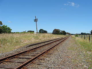
The Mangamaire railway station on the Wairarapa Line was located in the Tararua District of the Manawatū-Whanganui region in New Zealand’s North Island.

The Konini railway station on the Wairarapa Line was located in the Tararua District of the Manawatū-Whanganui region in New Zealand’s North Island.
The Ngawapurua railway station on the Wairarapa Line was located in the Tararua District of the Manawatū-Whanganui region in New Zealand’s North Island.
Ballance is a farming community in Tararua District and Manawatū-Whanganui region of New Zealand's North Island. The main settlement is located on the west back of the Mangahao River, south and west of Woodville and 11 km north-west of Pahiatua.
Kumeroa is a farming settlement in Tararua District and Manawatū-Whanganui region of New Zealand's North Island. It is about ten minutes' drive from Woodville, on the opposite side of the Manawatū River.
The Northern Crossing is a tramping track in New Zealand's Tararua Range. The track is approximately 50 kilometres (31 mi) long and typically takes between three and five days to complete. The crossing is suitable only for experienced trampers.

