Related Research Articles

Mount Erebus is the southernmost active volcano on Earth, located on Ross Island in the Ross Dependency in Antarctica. With a summit elevation of 3,794 metres (12,448 ft), it the second most prominent mountain in Antarctica and the second-highest volcano in Antarctica. It is the highest point on Ross Island, which is also home to three inactive volcanoes: Mount Terror, Mount Bird, and Mount Terra Nova. It makes Ross Island the sixth-highest island on Earth.

Koettlitz Glacier is a large Antarctic glacier lying west of Mount Morning and Mount Discovery in the Royal Society Range, flowing from the vicinity of Mount Cocks northeastward between Brown Peninsula and the mainland into the ice shelf of McMurdo Sound.

Marguerite Bay or Margaret Bay is an extensive bay on the west side of the Antarctic Peninsula, which is bounded on the north by Adelaide Island and on the south by Wordie Ice Shelf, George VI Sound and Alexander Island. The mainland coast on the Antarctic Peninsula is Fallières Coast. Islands within the bay include Pourquoi Pas Island, Horseshoe Island, Terminal Island, and Lagotellerie Island. Marguerite Bay was discovered in 1909 by the French Antarctic Expedition under Jean-Baptiste Charcot, who named the bay for his wife.

The Wright Valley is a large east–west trending valley, formerly occupied by a glacier but now ice free except for Wright Upper Glacier at its head and Wright Lower Glacier at its mouth, in Victoria Land, Antarctica. It was named by the VUWAE (1958-59) for Sir Charles Wright, for whom the BrAE (1910-13) named the glacier at the mouth of this valley.
Mikkelsen Bay is a bay, 15 nautical miles wide at its mouth and indenting 10 nautical miles, entered between Bertrand Ice Piedmont and Cape Berteaux along the west coast of Graham Land, Antarctica.
Neny Fjord is a bay, 10 nautical miles long in an east–west direction and 5 nautical miles wide, between Red Rock Ridge and Roman Four Promontory on the west coast of Graham Land, Antarctica.
Lützow-Holm Bay is a large bay, about 220 kilometres (120 nmi) wide, indenting the coast of Queen Maud Land in Antarctica between Riiser-Larsen Peninsula and the coastal angle immediately east of the Flatvaer Islands. It was discovered by Captain Hjalmar Riiser-Larsen in two airplane flights from his expedition vessel, the Norvegia, on February 21 and 23, 1931. The name honours Commander Finn Lützow-Holm of the Royal Norwegian Navy Air Service, a pilot for Captain Riiser-Larsen on the Aagaard in 1935.

Hut Point Peninsula is a long, narrow peninsula from 2 to 3 nautical miles wide and 15 nautical miles long, projecting south-west from the slopes of Mount Erebus on Ross Island, Antarctica. McMurdo Station (US) and Scott Base (NZ) are Antarctic research stations located on the Hut Point Peninsula.
Mount Bird is a 1,765 metres (5,791 ft) high shield volcano standing about 7 nautical miles south of Cape Bird, the northern extremity of Ross Island. It was mapped by the British National Antarctic Expedition, 1901–04, under Robert Falcon Scott, and apparently named by them after Cape Bird.

Barff Peninsula is a peninsula forming the east margin of Cumberland East Bay, South Georgia Island. It is 8 miles (13 km) long and extends northwest from Sörling Valley to Barff Point, its farthest extremity. It was probably first seen by the British expedition under James Cook in 1775. The peninsula as a whole takes its name from Barff Point, which was named for Royal Navy Lieutenant A.D. Barff of HMS Sappho, who, assisted by Captain C.A. Larsen, sketched a map of Cumberland Bay in 1906. Barff Point is considered the eastern headland of East Cumberland Bay.

Cumberland West Bay is a bay forming the western arm of Cumberland Bay, South Georgia. It is entered southward of Larsen Point, where it is 2.5 miles (4 km) wide and extends 7 miles (11 km) in a southwest direction. It is separated from Cumberland East Bay by Thatcher Peninsula. Papua Beach is situated on its southeast shore.
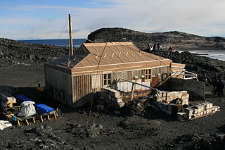
Cape Royds is a dark rock cape forming the western extremity of Ross Island, facing on McMurdo Sound, Antarctica. It was discovered by the British National Antarctic Expedition (BrNAE) (1901–1904) and named for Lieutenant Charles Royds, Royal Navy, who acted as meteorologist on the expedition. Royds subsequently rose to become an Admiral and was later Commissioner of the Metropolitan Police, London. The cape is the site of Shackleton's Hut, the expedition camp of the British Antarctic Expedition, 1907–09.

Greene Peninsula is a mountainous peninsula within Cumberland East Bay, separating Moraine Fjord to the west from the main arm of Cumberland East Bay, on the north coast of South Georgia Island. The entire area was charted by the Swedish Antarctic Expedition (SAE), 1901–04, under Otto Nordenskjöld. The peninsula was named by the UK Antarctic Place-Names Committee (UK-APC) in 1979 after Stanley Wilson Greene, a British bryologist who worked in South Georgia.
Suter Island is a small island off the Vestfold Hills, lying 0.5 miles (0.8 km) southwest of the south entrance point to Heidemann Bay. Mapped by Norwegian cartographers from air photos taken by the Lars Christensen Expedition, 1936–37. Named by Antarctic Names Committee of Australia (ANCA) for William James (Bill) Suter, cook at Davis Station in 1960.

Nicholson Peninsula is a broad ice-covered peninsula about 15 nautical miles (28 km) long, between Couzens Bay and Matterson Inlet on the Shackleton Coast on the west side of the Ross Ice Shelf, Antarctica.
Kista Strait is a strait between the Flat Islands and Jocelyn Islands in Holme Bay, Mac. Robertson Land, Antarctica. It was mapped by Norwegian cartographers from air photos taken by the Lars Christensen Expedition, 1936–37. The strait was first navigated by the site on which Australian National Antarctic Research Expeditions (ANARE) established Mawson Station.
Saint Johns Range is a crescent-shaped mountain range about 20 nautical miles long, in Victoria Land, Antarctica. It is bounded on the north by the Cotton Glacier, Miller Glacier and Debenham Glacier, and on the south by Victoria Valley and the Victoria Upper Glacier and Victoria Lower Glacier.
Station Tarn is a small fresh-water pond near the west end of Breidnes Peninsula, Vestfold Hills, immediately north of Heidemann Bay in Princess Elizabeth Land in Antarctica. So named by the first ANARE party at Davis Station because of its proximity.
Torckler Rocks are three small islands lying at the north side of the entrance to Heidemann Bay, Vestfold Hills. Mapped by Norwegian cartographers from air photos taken by the Lars Christensen Expedition, 1936–37. Remapped from ANARE air photos and named for R.M. Torckler, radio officer at Davis Station in 1959.
References
- ↑ "Heidemann Bay". Geographic Names Information System . United States Geological Survey, United States Department of the Interior . Retrieved 2012-06-08.
![]() This article incorporates public domain material from "Heidemann Bay". Geographic Names Information System . United States Geological Survey.
This article incorporates public domain material from "Heidemann Bay". Geographic Names Information System . United States Geological Survey.
| | This Princess Elizabeth Land location article is a stub. You can help Wikipedia by expanding it. |