Related Research Articles
Beetzendorf-Diesdorf is a Verbandsgemeinde in the Altmarkkreis Salzwedel (district), in Saxony-Anhalt, Germany. Until 1 January 2010, it was a Verwaltungsgemeinschaft. It is situated southwest of Salzwedel. The seat of the Verbandsgemeinde is in Beetzendorf.

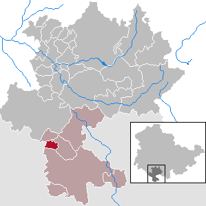
Bad Colberg-Heldburg is a former municipality in the region Heldburger Land in the district of Hildburghausen, in Thuringia, Germany. It is situated 16 km south of Hildburghausen, and 18 km west of Coburg. It was created in 1993 by the merger of the former municipalities of Bad Colberg, Gellershausen, Heldburg, Holzhausen, Lindenau and Völkershausen. Since 1 January 2019, it is part of the town Heldburg.
Bad Dürrenberg was a Verwaltungsgemeinschaft in the Saalekreis district, in Saxony-Anhalt, Germany. The seat of the Verwaltungsgemeinschaft was in Bad Dürrenberg. It was disbanded on 1 January 2010.
Bernburg was a Verwaltungsgemeinschaft in the Salzlandkreis district, in Saxony-Anhalt, Germany. The seat of the Verwaltungsgemeinschaft was in Bernburg. It was disbanded on 1 January 2010.
Oberes Sprottental is a Verwaltungsgemeinschaft in the district Altenburger Land, in Thuringia, Germany. The seat of the Verwaltungsgemeinschaft is in Nöbdenitz, which is part of the town Schmölln.
Nesseaue is a Verwaltungsgemeinschaft in the district of Gotha, in Thuringia, Germany. The seat of the Verwaltungsgemeinschaft is in Friemar.
Westerwald-Obereichsfeld is a Verwaltungsgemeinschaft in the district Eichsfeld, in Thuringia, Germany. The seat of the Verwaltungsgemeinschaft is in Küllstedt.

Westhausen is a municipality in the region Heldburger Land in the district of Hildburghausen, in Thuringia, Germany.

Gompertshausen is a village and a former municipality in the region Heldburger Land in the district of Hildburghausen, in Thuringia, Germany. Since 1 January 2019, it is part of the town Heldburg.
Hellingen is a village and a former municipality in the region Heldburger Land in the district of Hildburghausen, in Thuringia, Germany. Since 1 January 2019, it is part of the town Heldburg. It was the southernmost municipality in Thuringia, and the second-southernmost in what was formerly East Germany.
Schlechtsart is a municipality in the region Heldburger Land in the district of Hildburghausen, in Thuringia, Germany.

Schweickershausen is a municipality in the region Heldburger Land in the district of Hildburghausen, in Thuringia, Germany.
Südliches Saaletal is a Verwaltungsgemeinschaft in the district Saale-Holzland, in Thuringia, Germany. The seat of the Verwaltungsgemeinschaft is in Kahla, itself not part of the Verwaltungsgemeinschaft.
Triptis is a Verwaltungsgemeinschaft in the district Saale-Orla-Kreis, in Thuringia, Germany. The seat of the Verwaltungsgemeinschaft is in Triptis.
Ranis-Ziegenrück is a Verwaltungsgemeinschaft in the district Saale-Orla-Kreis, in Thuringia, Germany. The seat of the Verwaltungsgemeinschaft is in Ranis.
Seenplatte is a Verwaltungsgemeinschaft in the district Saale-Orla-Kreis, in Thuringia, Germany. The seat of the Verwaltungsgemeinschaft is in Oettersdorf.

The Heldburger Land was the historical, Saxon, administrative district (Amtsbezirk) of Heldburg and is today the southernmost part of the Free State of Thuringia and the district of Hildburghausen, between the towns of Coburg, Hildburghausen and Bad Königshofen. The region known now as the Heldburger Land is referred to administratively as the Heldburger Unterland, and sometimes in the vernacular as the Heldburger Zipfel.
The German Castle Museum is a history museum at Heldburg Fortress in the region of Heldburger Land and in the county of Hildburghausen in the German state of Thuringia.
Heldburg Fortress is a high medieval hilltop castle. In the 16th century it was rebuilt into a renaissance castle. It rises on a former volcanic region to 'Heldburger Gangschar' counted, 405-metre-high volcanic cone, 113 metres above the town of Heldburg in the Heldburger Land, the southern tip of the district Hildburghausen in Thuringia. The Veste Heldburg, once a secondary residence and hunting lodge of the Dukes of Coburg, dominates the little town of Heldburg on the Thuringian border with Bavaria. From it can be seen across the Thuringian border the sister-castle Veste Coburg,, once the residence of the Dukes of Coburg, now located in Bavaria.
The Heldburger Gangschar is a Cenozoic volcanic system in the Franconian parts of southern Thuringia and northern Bavaria. The term Gangschar refers to the fact that few of the volcanoes have retained their characteristic topographical shape, rather their former activity can be detected by filled fissures known as Gänge. These veins are mostly oriented in south-southwest direction, their cross-section is often less than one metre wide. The Heldburger Gangschar' is named after the small settlement of Heldburg, part of the borough of Bad Colberg-Heldburg. The surrounding area, the Heldburger Land, belongs entirely to the northern part of the volcanic zone. The most impressive of the surviving volcanic cones by far are the twin peaks of the Gleichberge, 641 metres and 679 metres high, in nearby Heldburger Land.
References
Coordinates: 50°16′59″N10°43′59″E / 50.283°N 10.733°E
| | This Hildburghausen district location article is a stub. You can help Wikipedia by expanding it. |