Brockworth is a village and parish in the Borough of Tewkesbury, Gloucestershire, England, situated on the old Roman road that connects the City of Gloucester with Barnwood. It is located 4 miles (6.4 km) southeast of central Gloucester, 6 miles (9.7 km) southwest of Cheltenham and 11.5 miles (18.5 km) north of Stroud. The population taken at the 2011 census was 7,387. The population increased to 9,422 at the 2021 Census.
Whitfield is a hamlet in South Gloucestershire, England.

Gloucester is a constituency centred on the cathedral city and county town of the same name, represented in the House of Commons of the UK by Alex McIntyre of the Labour Party

Gloucester Castle was a Norman-era royal castle situated in the city of Gloucester in Gloucestershire, England. It was demolished in 1787 and replaced by Gloucester Prison.

Podsmead is a district of Gloucester approximately one mile from the historic city centre. With the development of Quedgeley and Kingsway Village, Podsmead was becoming absorbed by the city in the early 21st century. The population of this Gloucester Ward was 2,994 at the 2011 Census. It is close to the hamlet of Hempsted.
Gloucestershire Parkway railway station is or was a proposed development in transport infrastructure for a semi-greenfield site surrounded by warehouse and light industry units 1.4 miles (2.3 km) east of Gloucester city centre which is on a major east–west spur line off of the greater north-south Birmingham-to-Bristol line on which this station would be built. The proposed site is specifically by an intra-city (urban) part of the inceptive A40 road in an area known as Elmbridge Court, Gloucester, England.

Llanthony Secunda Priory was a house of Augustinian canons in the parish of Hempsted, Gloucestershire, England, situated about 1/2 a mile south-west of Gloucester Castle in the City of Gloucester. It was founded in 1136 by Miles de Gloucester, 1st Earl of Hereford, a great magnate based in the west of England and the Welsh Marches, hereditary Constable of England and Sheriff of Gloucestershire, as a secondary house and refuge for the canons of Llanthony Priory in the Vale of Ewyas, within his Lordship of Brecknock in what is now Monmouthshire, Wales. The surviving remains of the Priory were designated as Grade I listed in 1952 and the wider site is a scheduled ancient monument. In 2013 the Llanthony Secunda Priory Trust received funds for restoration work which was completed in August 2018 when it re-opened to the public.
Moreland is an area and electoral ward in the City of Gloucester, Gloucestershire, England. The area is commonly known locally as Linden: the electoral ward is named after the Moreland match factory which closed in 1976. The population of the Gloucester ward was 10,253 at the 2011 Census.

Hempsted is a suburban village and former civil parish, on the edge of Gloucester in the county of Gloucestershire, England. The parish was abolished in 1966 and absorbed into the parish and city of Gloucester. In 1961 the parish had a population of 508. The current estimated population based on small area data of the 2021 ONS census is 2715.

Maine School Administrative District 15 is a public school district that operates three elementary schools, one middle school (5–8) and one high school (9–12) in Cumberland County in the U.S. state of Maine. The school system serves the towns of Gray, Maine and New Gloucester, Maine. The school system is run by a school board and superintendent system. The school system was established in 1960, and the high school opened in 1962.

St Mary de Lode Church is a Church of England church immediately outside the grounds of Gloucester Cathedral. It is believed by some to be on the site of the first Christian church in Britain. The church is in the Diocese of Gloucester and Grade I listed by English Heritage. It has also been known as St. Mary Before the Gate of St. Peter, St. Mary Broad Gate and St. Mary De Port.

Gloucester Court of Probate is a grade II listed building at 3–4 Pitt Street, Gloucester in England.

There are no records to state that the house was built in the 1200's. It was in fact built in the 1400's.

Bearland House is a grade II* listed building in Longsmith Street, Gloucester, England.

The Fleece Hotel, Westgate Street, Gloucester is a timber framed building dating from the 15th century, which incorporated a 12th-century stone undercroft. The building is part grade I and part grade II listed with Historic England.

Longsmith Street is a street in Gloucester that runs from Bearland in the north to Southgate Street in the south.

Our Lady's Well is a holy well house in Hempsted, Gloucester. It was designated as a Grade I listed building in January 1955.

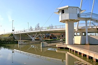
High Orchard Bridge is a bascule bridge over the Gloucester and Sharpness Canal in High Orchard in the city of Gloucester, England. It was opened in 2008 to carry the newly constructed St Ann Way over the canal. In 2012, Marstons pub company opened a brand new pub on the land next to the bridge and named it after the bridge “The High Orchard” which has since gone on to be one of Gloucester’s busiest pubs.

Norfolk Buildings is a terrace of grade II listed houses at 73-91 Bristol Road, Gloucester, on the east side between Theresa Street and Alma Place.

Bristol Road in the City of Gloucester dates from the medieval period. It runs between Southgate Street in the north and Quedgeley in the south where it joins the Bath Road and the A38. It contains a number of listed buildings and other notable structures.


