Hen Gwrt Moated Site

Last updated

Hen Gwrt Moated Site
Hen Gwrt, Llantilio Crossenny, Monmouthshire, UK.jpg
The moat and site
TypeSite
Location Llantilio Crossenny, Monmouthshire
Coordinates 51°49′53″N2°52′42″W / 51.8315°N 2.8782°W / 51.8315; -2.8782 Coordinates: 51°49′53″N2°52′42″W / 51.8315°N 2.8782°W / 51.8315; -2.8782
Governing body CADW
Official nameHen Gwrt Moated Site, Llantilio Crossenny
Designated1941
Reference no.MM094
Monmouthshire UK relief location map.jpg
Red pog.svg
Location of Hen Gwrt Moated Site in Monmouthshire

Hen Gwrt, (English:Old Court), Llantilio Crossenny, Monmouthshire is the site of a thirteenth century manor house and a sixteenth century hunting lodge. Originally constructed for the Bishops of Llandaff, it subsequently came into the possession of the Herberts of Raglan Castle. The bishops constructed a substantial manor house on the site in the thirteenth century, which was moated in the fourteenth. The building was then adapted by the Herberts to create a lodge within their extensive hunting grounds. The lodge continued in use until the slighting of Raglan Castle in the English Civil War.

Contents

Historical accounts of Monmouthshire traditionally identify Hen Gwrt as the home of Dafydd Gam, the legendary opponent of Owain Glyndŵr and supporter of Henry V, but there is no evidence for this.

Work at the site in the early nineteenth showed evidence of the footings of the earlier buildings, which were mapped, but by the time of subsequent archaeological investigations in the twentieth century, all of the stone on the site had been removed for road metalling. Today, no trace of either the manor or the lodge remains, and the moated site is in the care of CADW.

History

In the Middle Ages ownership of the parish of Llantilio Crossenny was divided between the King and the Bishops of Llandaff, Llantelyo regis being the lands owned by the king and Llantelyo episcopi being those owned by the bishops. [1] The bishops administered their portion from Hen Gwrt. [1] This episcopal presence also accounts for the "exceptional scale" [2] and "unusual grand(eur)" [2] of the parish church, dedicated to St Teilo, which stands a little south of Hen Gwrt. [2] The bishops' manor is believed to have been of timber construction. [3]

By the reign of Henry VI, the manor had been leased to William ap Thomas [4] who had purchased the manor of Raglan in 1432 and begun the great expansion of the castle. [5] William, or possibly his son, William Herbert, [4] enclosed a substantial deer park, of some 250 hectares, [1] at Llantilio Crossenny. Elisabeth Whittle's Historic Gardens of Wales reproduces a map of 1610 by John Speed that shows the deer parks of Monmouthshire, including that centred at Hen Gwrt. [6] In the Herbert's ownership, in the sixteenth century, the bishops' timber manor was reconstructed as a stone [3] hunting lodge. [7]

William Herbert was the grandson of Dafydd Gam, through his father's second marriage to Gwladys ferch Dafydd Gam, [8] and this familial connection may account for the long-held tradition, repeated by both William Coxe and Sir Joseph Bradney, that Hen Gwrt was the site of Daffyd Gam's manor house. [4] In his Introduction to The Diary of Walter Powell of Llantilio Crossenny in the County of Monmouth, Gentleman, Bradney records that David Gam's; "seat was the castle called Hengwrt (Old Court), of which only the moat remains." [9] The church at Llantilio Crossenny has two stained glass windows, moved from Llantilio Court, showing the arms of Gam and of Herbert, [10] but there is no documentary evidence linking Gam to the Hen Gwrt site. [1]

In 1646, towards the end of the First English Civil War and after a three-month siege, Raglan Castle was surrendered to the Parliamentary forces of Thomas Fairfax by Henry Somerset, 1st Marquess of Worcester. [11] The surrender, and subsequent slighting, of the castle also saw the end of the use of Hen Gwrt as a hunting lodge [7] and its subsequent complete destruction. [4]

In 1941, Sir Henry Mather Jackson, whose grandfather, Sir William Jackson had bought the site in 1873, and who had also owned White Castle, gave guardianship of Hen Gwrt to the Ministry of Public Building and Works. [12] In that year, it was also designated a scheduled monument. [3] It is now in the care of CADW. [13]

Description

The site comprises an island, rectangular in plan, and measuring 39m by 45m. [7] The island is completely surrounded by a moat, giving dimensions of 72.5m by 76m overall, [7] and is connected by a modern bridge over the moat, although a beam from the original bridge survives. [3] The site offers no natural defences, and the platform within the moat has not been raised, suggesting that the moat was not intended to serve a serious defensive purpose. [4]

Describing Hen Gwrt in his 2016 walking guide Offa's Dyke Pass, Mike Dunn writes; "the moat is clogged with bulrushes but still very picturesque and the site is open and grassy." [14]

Archaeology and excavations

Writing in 2000, in his Greater Medieval Houses of England and Wales, 1300-1500, Anthony Emery noted that "Hen Gwrt is one of the few (moated) sites to have been thoroughly examined." [15] In the 1820s, a plan of "The foundations of the Old Court, taken as they were discovered" was drawn up at the time the stone from the site was removed for road metalling. [1] Craster and Lewis suggest an alternative use for the stone may have been in the building of Llantilio Court. [16] Whittle follows their suggestion and also notes that the associated changes to the road layout obliterated the southern corner of the site. [17] The plan shows the footings of a rectangular building, built in stone, and surrounded by a stone wall encircling the inner edge of the moat. [1] The building has both a large and a small chamber, and two rooms which probably housed latrines. [1] By the time of later excavations in the 1950s all traces of the stone foundations had gone, although elements indicating the earlier, timber-framed, manor house of the Bishops of Llandaff were uncovered. [1] These excavations, the most detailed undertaken at the site, were led by O.E. Craster and J.M. Lewis and their findings published in Volume 112 of the Archaeologia Cambrensis, the journal of the Cambrian Archaeological Association, in 1963. [18] CADW considers that the site still "offers considerable archaeological potential." [19]

Notes

  1. 1 2 3 4 5 6 7 8 Knight 2009, pp. 47–8.
  2. 1 2 3 Newman 2000, p. 350.
  3. 1 2 3 4 Newman 2000, p. 352.
  4. 1 2 3 4 5 Hen-cwrt Moated site, Llantilio Crossenny (ID PRN01388g) in the ' SMR ' for Glamorgan-Gwent Archaeological Trust (GGAT) . Retrieved 21 February 2017
  5. Kenyon 2003, p. 7.
  6. Whittle 1992a, p. 24.
  7. 1 2 3 4 "Hen Gwrt Moated Site, Llantilio Crossenny (94890)". Coflein. RCAHMW . Retrieved 21 February 2017.
  8. Fox 1954, p. 46.
  9. Powell 1907, p. x.
  10. Cadw. "Church of St Teilo, Llantilio Crossenny (Grade I) (2073)". National Historic Assets of Wales . Retrieved 8 May 2022.
  11. Tribe 2002, p. 11.
  12. Craster/Lewis 1963, p. 166.
  13. "Hen Gwrt Moated Site". Cadw.gov.wales. Retrieved 22 February 2017.
  14. Dunn 2016, p. 63.
  15. Emery 2000, p. 688.
  16. Craster/Lewis 1963, p. 168.
  17. Whittle 1992b, p. 100.
  18. "Medieval Published Bibliography". Cpat.org.uk. 22 December 2003. Retrieved 22 February 2017.
  19. Cadw. "Hen Gwrt Moated Site (MM094)". National Historic Assets of Wales . Retrieved 18 April 2017.

Related Research Articles

<span class="mw-page-title-main">Raglan Castle</span> Late medieval castle in Monmouthshire, Wales

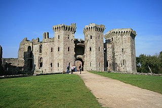
Raglan Castle is a late medieval castle located just north of the village of Raglan in the county of Monmouthshire in south east Wales. The modern castle dates from between the 15th and early 17th centuries, when the successive ruling families of the Herberts and the Somersets created a luxurious, fortified castle, complete with a large hexagonal keep, known as the Great Tower or the Yellow Tower of Gwent. Surrounded by parkland, water gardens and terraces, the castle was considered by contemporaries to be the equal of any other in England or Wales.

<span class="mw-page-title-main">Dafydd Gam</span> Welsh warrior (1380–1415)

Dafydd ap Llewelyn ap Hywel, better known as Dafydd Gam, anglicized to David or Davy Gam, was a Welsh warrior, a prominent opponent of Owain Glyndŵr. He died at the Battle of Agincourt fighting for Henry V, King of England in that victory against the French.

<span class="mw-page-title-main">William ap Thomas</span> Welsh noble (died 1445)

Sir William ap Thomas was a Welsh nobleman, politician, knight, and courtier. He was a member of the Welsh gentry family that came to be known as the Herbert family through his son William Herbert, 1st Earl of Pembroke and is the agnatic ancestor, via an illegitimate descendant of the 1st Earl of the 8th creation, of the current Herbert family of the Earl of Pembroke and Montgomery, and also of the Herbert Earl of Carnarvon.

<span class="mw-page-title-main">Raglan, Monmouthshire</span> Village in Monmouthshire, Wales

Raglan (; is a village and community in Monmouthshire, south east Wales, United Kingdom. It is located some 9 miles south-west of Monmouth, midway between Monmouth and Abergavenny on the A40 road very near to the junction with the A449 road. The fame of the village derives from Raglan Castle, built for William ap Thomas and now maintained by Cadw. The community includes the villages of Llandenny and Pen-y-clawdd. Raglan itself has a population of 1,183.

<span class="mw-page-title-main">Clytha Castle</span> Folly in Clytha, Monmouthshire

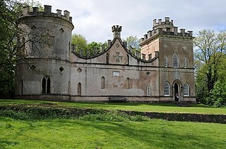
Clytha Castle is a folly near Clytha between Llanarth and Raglan in Monmouthshire, south east Wales. Dating from 1790, the castle was built by William Jones, owner of the Clytha Park estate as a memorial to his wife, Elizabeth, who died in 1787. The castle is an example of the Gothic Revival and comprises three towers, of which two are habitable, and linking, castellated curtain walls. Long attributed to John Nash, recent research has confirmed that the architect was John Davenport of Shrewsbury. The folly has views towards the Sugar Loaf and Skirrid mountains on the easternmost edge of the Brecon Beacons National Park. Described by the architectural historian John Newman as one of the two "outstanding examples of late eighteenth century fanciful Gothic in the county", Clytha Castle is a Grade I listed building.

<span class="mw-page-title-main">Llantilio Crossenny</span> Human settlement in Wales

Llantilio Crossenny is a small village and much larger former community, now in the community of Whitecastle, in Monmouthshire, south east Wales, in the United Kingdom. It is situated between the two towns of Abergavenny and Monmouth on the B4233 road. The community included Penrhos, and Llanvihangel-Ystern-Llewern.

<span class="mw-page-title-main">Clytha Park</span> House in Clytha, Monmouthshire

Clytha Park, Clytha, Monmouthshire, is a 19th-century Neoclassical country house, "the finest early nineteenth century Greek Revival house in the county." The wider estate encompasses Monmouthshire's "two outstanding examples of late eighteenth century Gothic", the gates to the park and Clytha Castle. The owners were the Jones family, later Herbert, of Treowen and Llanarth Court. It is a Grade I listed building.

<span class="mw-page-title-main">St Teilo's Church, Llantilio Crossenny</span> Church in Monmouthshire, Wales

The Church of St Teilo is the parish church of Llantilio Crossenny, Monmouthshire, Wales. "An unusually grand cruciform church", with an Early English tower crossed by a Decorated chancel, it was designated a Grade I listed building on 19 November 1953

<span class="mw-page-title-main">Grade I listed buildings in Monmouthshire</span>

Monmouthshire is a county and principal area of Wales. It borders Torfaen and Newport to the west; Herefordshire and Gloucestershire to the east; and Powys to the north. The largest town is Abergavenny, with other large settlements being Chepstow, Monmouth, and Usk. The present county was formed under the Local Government (Wales) Act 1994, and comprises some sixty percent of the historic county. Between 1974 and 1996, the county was known by the ancient title of Gwent, recalling the medieval Welsh kingdom. The county is 850 km2 in extent, with a population of 95,200 as of 2020.

<span class="mw-page-title-main">Moynes Court</span> Historic site in Monmouthshire, Wales

Moynes Court is a Grade II* listed building in the village of Mathern, Monmouthshire, Wales, about 3 miles (4.8 km) south west of Chepstow. An earlier building was rebuilt as a private residence by Francis Godwin, Bishop of Llandaff, in about 1609/10, and much of the building remains from that period. Its grounds contain earthworks thought to be the foundations of an earlier moated manor house. The gatehouse to the court has a separate Grade II* listing. The garden at the court is on the Cadw/ICOMOS Register of Parks and Gardens of Special Historic Interest in Wales.

<span class="mw-page-title-main">St Cenedlon's Church, Rockfield</span> Church located in Monmouthshire, Wales

St Cenedlon's is a parish church in the village of Rockfield, Monmouthshire, Wales. The dedication to St Cenedlon is unusual and the history of the saint is obscure. Some sources suggest that she was a daughter of Brychan king of Brycheiniog while others identify her as the wife of King Arthfael ab Ithel, king of Glywysing. The existing church dates from the Middle Ages but only the tower remains from that period. After the English Reformation, the surrounding area of north Monmouthshire became a refuge for Catholics and Matthew Pritchard (1669-1750), Roman Catholic bishop and Vicar Apostolic of the Western District is buried at the church. By the mid-19th century the church was in ruins and a complete reconstruction was undertaken by the ecclesiastical architects John Pollard Seddon and John Prichard in around 1860. St Cenedlon's is an active parish church in the Diocese of Monmouth. It is designated by Cadw as a Grade II listed building.

<span class="mw-page-title-main">Tal-y-coed Court</span> House in Llanvihangel-Ystern-Llewern, Monmouthshire

Tal-y-coed Court,, Llanvihangel-Ystern-Llewern, Monmouthshire, Wales, is a Victorian country house. Constructed in 1881–1883, it was built for the Monmouthshire antiquarian Joseph Bradney, author of A History of Monmouthshire from the Coming of the Normans into Wales down to the Present Time. A Grade II* listed building, the house is a "fine historicist essay in the Queen Anne Style, one of the earliest examples in Wales." Its gardens and park are designated Grade II on the Cadw/ICOMOS Register of Parks and Gardens of Special Historic Interest in Wales.

<span class="mw-page-title-main">The Artha, Tregare</span> Farmhouse in Tregare, Monmouthshire

The Artha, Tregare, Monmouthshire is a farmhouse dating from the mid-17th century. It is a Grade II* listed building.

<span class="mw-page-title-main">Llansantffraed, Monmouthshire</span> Human settlement in Wales

Llansantffraed is the smallest parish in Monmouthshire, Wales, located four miles to the west of Raglan, north of the A40 between Raglan and Abergavenny. There is no community, only the Llansantffraed Court estate and the church.

<span class="mw-page-title-main">The Old Cottage, Treadam, Llantilio Crossenny</span> House in Llanvihangel Crucorney, Monmouthshire

The Old Cottage, in the hamlet of Treadam, some 2km north-west of Llantilio Crossenny, Monmouthshire, is a country house dating from c.1600. The house is Grade II* listed.

<span class="mw-page-title-main">Treworgan Manor, Llansoy</span> House in Llansoy, Monmouthshire

Treworgan Manor, Llansoy, Monmouthshire is a country house dating from the early 18th century. Its origins are older, from the 16th century. Long in the possession of the Prichard family, it changed hands a number of times in later centuries and remains a private residence. The house is Grade II* listed, its listing describing it as a "fine Renaissance house". An adjacent barn has its own Grade II Listing.

<span class="mw-page-title-main">Wern-ddu Farmhouse, Llantilio Pertholey</span> Farmhouse in Llantilio Pertholey, Monmouthshire

Wern-ddu farmhouse, Llantilio Pertholey, Monmouthshire is a farmhouse of 17th century origins. It has been significantly altered in the 18th, 19th and 20th centuries and the Monmouthshire antiquarian, Sir Joseph Bradney recorded that it had "suffered so much by continual alterations that it shows but little of its antiquity". It is a Grade II* listed building.

<span class="mw-page-title-main">Great Killough</span> Manor house in Llantilio Crossenny, Monmouthshire

Great Killough, Llantilio Crossenny, Monmouthshire is a substantial manor house of late medieval origins. The majority of the current structures date from three building periods from 1600 to 1670. It is a Grade II* listed building.

<span class="mw-page-title-main">Perth-hir House</span> House in Rockfield, Monmouthshire

Perth-hir House, Rockfield, Monmouthshire, Wales, was a major residence of the Herbert family. It stood at a bend of the River Monnow, to the north-west of the village. At its height in the 16th century, the mansion, entered by two drawbridges over a moat, comprised a great hall and a number of secondary structures. Subsequently in the ownership of the Powells, and then the Lorimers, the house became a centre of Catholic recusancy following the English Reformation. By the 19th century, the house had declined to the status of a farmhouse and it was largely demolished in around 1830. Its ruins, and the site which contains considerable remnants of a Tudor garden, are a scheduled monument.

<span class="mw-page-title-main">Registered historic parks and gardens in Monmouthshire</span> List of buildings in county of Wales

Monmouthshire is a county and principal area of Wales. It borders Torfaen and Newport to the west; Herefordshire and Gloucestershire to the east; and Powys to the north. The largest town is Abergavenny, with other large settlements being Chepstow, Monmouth, and Usk. The present county was formed under the Local Government (Wales) Act 1994, and comprises some sixty percent of the historic county. Between 1974 and 1996, the county was known by the ancient title of Gwent, recalling the mediaeval Welsh kingdom. The county is 850 km2 in extent, with a population of 93,200 as of 2021.

References