Related Research Articles

Coventry is a city in the West Midlands, England. It is on the River Sherbourne. Coventry has been a large settlement for centuries, although it was not founded and given its city status until the Middle Ages. The conurbation consists of the Coventry and Bedworth Urban Area, the 20th largest in the country; the city is governed by Coventry City Council.

Clapham Park is an area in the Borough of Lambeth in London, to the south of central Clapham and west of Brixton.

Oldbury is a market town in the Metropolitan Borough of Sandwell, West Midlands, England. It is the administrative centre of the borough.

Pollok is a large housing estate on the south-western side of the city of Glasgow, Scotland. The estate was built either side of World War II to house families from the overcrowded inner city. Housing 30,000 at its peak, its population has since declined due to the replacement of substandard housing with lower-density accommodation.

Scotstoun is an area of Glasgow, Scotland, west of Glasgow City Centre. It is bounded by Garscadden and Yoker to the west, Victoria Park, Jordanhill and Whiteinch to the east, Jordanhill to the north and the River Clyde to the south. At the heart of Scotstoun lies Scotstounhill, an enclave of late Victorian and post-war housing centred on Scotstounhill railway station. Scotstoun is home to BAE Systems Surface Ships, and to the Glasgow Warriors rugby team.
Downham is a district of south-east London, England, within the London Borough of Lewisham. It borders the London Borough of Bromley, and is located north of Bromley and south of Catford.

Seacroft is an outer-city suburb/township consisting mainly of council estate housing covering an extensive area of east Leeds, West Yorkshire, England. It lies in the LS14 Leeds postcode area, around 4 miles (6.4 km) east of Leeds city centre.
Beauchief and Greenhill ward—which includes the districts of Batemoor, Beauchief, Chancet Wood, Greenhill, Jordanthorpe, Lowedges and Meadow Head—is one of the 28 electoral wards in the City of Sheffield, England. It is in the southern part of the city and covers an area of 2.4 square miles (6.2 km2). The population of the ward in 2016 was estimated to be 19,669 people in 9,209 houses.

Firth Park ward—which includes the districts of Firth Park, Longley, Parson Cross and parts of Wincobank—is one of the 28 electoral wards in City of Sheffield, England located in the northern part of the city and covering an area of 1.66 square miles (4.3 km2). The population of this ward in 2011 was 21,141 people in 8,602 households.

Edmonton is an area in north London, England within the London Borough of Enfield. The northern part of the town is known as Edmonton Green or Lower Edmonton, and the southern part as Upper Edmonton. Situated 8.4 miles (13.5 km) north-northeast of Charing Cross, it borders Ponders End and Bush Hill Park in Enfield to the north, Chingford to the east, and Tottenham to the south, with Palmers Green and Winchmore Hill to the west. The population of Edmonton was 82,472 as of 2011.
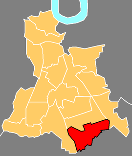
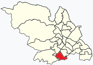
Walsgrave on Sowe, or simply Walsgrave, is a suburban district situated approximately 3.5 miles (5.6 km) north-east of central Coventry, West Midlands, central England. Although it now experiences very little flooding, it was built on marshlands. However, due to urban growth, it is now an outer suburb of Coventry, south-west of the villages of Ansty and Shilton. Walsgrave on Sowe neighbours the Potters Green, Clifford Park, Woodway Park, Wyken, Henley Green and Mount Pleasant areas of Coventry, and is in the Henley ward of the city, although Walsgrave-on-Sowe was formerly in the Wyken Ward prior to ward changes made in 2003 by the Local Government Boundary Commission for England (LGBCE).

Canley is a suburban neighbourhood located in southwest Coventry, England. Canley became part of Coventry as a result of successive encroachment of the latter's boundaries between 1928 and 1932, having historically been part of the Stoneleigh parish. Electorally, it is largely in Westwood ward and partially within the Wainbody and Earlsdon wards.
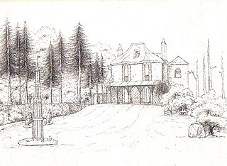
Woodway House is in Teignmouth, South Devon, England. It was at one time a farm on lands held by the Bishops of Exeter. In around 1815 a thatched "cottage" in the "cottage ornée" style of Horace Walpole's (1717–1797) Thames-side villa, Strawberry Hill, was built here by Captain James Spratt of the Royal Navy.
Radford is a suburb and electoral ward of Coventry, located approximately 1.5 miles north of Coventry city centre. It is covered by the Coventry North West constituency.
Potters Green is a mainly residential suburb situated in the northeast of the city of Coventry, West Midlands, England. The longest road is Woodway Lane, while the road used by through traffic is Ringwood Highway, which provides a link between Woodway Lane, Wigston Road and Deedmore Road.

Tile Hill is a suburb in the west of Coventry, West Midlands, England. It is mostly residential and partly industrial, with some common land and wooded areas. Tile Hill railway station is located on the West Coast Main Line which links Coventry with London and Birmingham, and is situated at the southwestern border with the city's Canley district and the Metropolitan Borough of Solihull.
Longford is a ward in the north of Coventry, West Midlands, England. The population of the Ward as taken at the 2011 census was 18,538. It is covered by the Coventry North East constituency and bounded by the wards of Holbrooks, Henley, Upper Stoke and Foleshill.

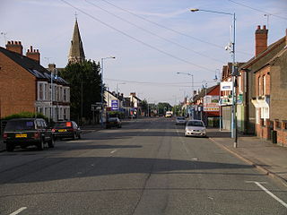
Bell Green is predominantly a residential area of in the north east of Coventry, West Midlands, England about 2.5 miles from the city centre. It was once home to over 50 different types of shops but due to the current economic climate and the council charging high rental prices for out of town shopping, there now remains only a handful.
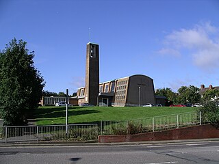
Stoke Heath is a residential area of Coventry, West Midlands, England. It is situated approximately 1 mile (1.6 km) to the north east of the city centre. It borders Courthouse Green to the north, Wyken to the east and Stoke to the south with its western edge demarcated by the A444.

The Coventry ring road, also known by its road number, A4053, is a 3.62-kilometre (2.25 mi) ring road in Coventry, England, which forms a complete dual-carriageway loop around the city centre. The road's circuit encompasses the old and new Coventry Cathedrals, Coventry University, shopping areas including the Upper and Lower Precincts, West Orchards and Cathedral Lanes, the medieval Spon Street and the Coventry Skydome. With the exception of one roundabout at junction 1, the ring road's other eight junctions are entirely grade separated and closely spaced, with short weaving sections between them, giving the road a reputation for being difficult to navigate. The junctions include connections with three other A roads: the A4114, linking Coventry to the A45, A46, M1 and M40, and also westbound towards Birmingham; and the A4600, which also connects with the A428, A444, M6 and M69; and the A429 to Kenilworth.
References
- 1 2 "About Henley ward". Coventry City Council. Archived from the original on 6 April 2013. Retrieved 6 May 2012.
- ↑ Junday, Tina (30 April 2009). "Arson-hit pub in Henley Green branded an "eyesore"". Coventry Telegraph . Retrieved 11 April 2011.
- ↑ Simpson, Cara (27 February 2012). "Henley Green leisure centre celebrates third anniversary". Coventry Telegraph . Retrieved 6 May 2012.
- ↑ "Welcome to the Moat House Leisure & Neighbourhood Centre". Coventry Sports Trust. Archived from the original on 5 May 2012. Retrieved 6 May 2012.
- ↑ "Moat House Leisure". Godiva Awards. Retrieved 6 May 2012.
- ↑ "Listen to the highlights of the 2010 Godiva Awards". BBC Online . Retrieved 6 May 2012.