Holbrooks

Last updated

Coventry Arena Rail Station. Coventry Arena 22 Jan 2016 14.JPG
Coventry Arena Rail Station.

Holbrooks is a residential area of Coventry, West Midlands, England.

Contents

Most of the length of the four brooks which pass through the area are covered or culverted, one culvert is adjacent to the recently built housing on Watery Lane. Another brook passes through and under the grounds of Parkgate School. The brooks then head off towards the river Sherbourne and the Sowe.

Holbooks is situated some 3 mi (5 km) north-west to the city centre and was largely developed for private and council housing during the 1950s and to replace the many homes destroyed by air raids during the Second World War.

History


The 'Stadium' housing estate at the rear of Lythalls Lane is so called because the housing was built on the site of a former dog racing stadium. In 1928 the Stadium speedway track opened. The track was closed in 1936 and the following year a greyhound track opened on the site This remained in use until 1964 when it was replaced by the housing.

Children in Holbrooks now have fewer places to play as various pockets of land, once open spaces between development, are being swallowed up to in-fill, although Holbrooks Park, on Holbrook Lane, remains the area's largest open space.

Coventry Building Society Arena

Holbrooks is close to the Coventry Building Society Arena (formally the Ricoh Arena), (which was designed to have limited parking to promote bus travel and walking) a parking permit scheme is in place. The stadium, and the adjacent Arena Park Shopping Centre are served by Coventry Arena railway station, opened in 2016. The Arena is currently home to Coventry City FC and Wasps Rugby Union Club. It has hosted other sporting events including preliminary round football during the London 2012 Olympics (during which it was renamed the City of Coventry Stadium), and several music concerts. Notable acts who have played here include Bon Jovi 2008, Take That June 2009, and reformed Coventry bands The Specials and also The Enemy. Manchester band Oasis played the Ricoh during July 2009 and American act Pink, artist Alecia Moore played during 2010. The venue also includes a casino and large exhibition and conference centre.

Housing

Another notable social housing estate in Holbrooks is the area of Everdon Road. Built after the Second World War, and accessed from either Beake Avenue or Holbrook Lane, this is a more spacious well-designed housing estate with mostly three- and four-bedroom houses with large rooms and tall roofs. Also several one-bedroom bungalows with the same tall roof design. Due to the spacious layout of the estate, more bungalows were recently[ when? ] built as 'infill' and in the future more development is likely.

There are a number of four storey residential flats on Everdon Road too, some have open views across parkland. The shape of the Everdon estate forms a complete loop and includes a small row of shops with flats above. Everdon is regularly used by learner drivers to practice, due to there being many corners, curves and reversing opportunity, plus the road is quiet during the school day. Most houses face onto grassed areas, and the estate is bordered by the large Holbrook Park which is maintained by Coventry City Council.

Today

Today Holbrooks has a diverse and large cultural mix which includes a large number of Polish people. There are two Polish food stores along Holbrook Lane, and several other food outlets and ethnic restaurants. The Arena Park Shopping Centre, on the Foleshill-Holbrooks border, features several national chain stores along with one of the largest Tesco stores in the country. A Morrisons store on Parkgate Road offers an alternative supermarket choice. The area's single surviving post office is located on Holbrook Lane.

Holbooks Primary School is in the adjacent suburb of Foleshill. Schools for primary age (4–11) children in Holbrooks include Parkgate (one of the largest primary schools in Coventry), John Shelton Primary School, and Holy Family RC Primary School. Secondary education is provided at President Kennedy School in Rookery Lane.

Holbrooks is also a short distance from the former British Coal Keresley Colliery site which is now a large industrial estate of warehousing called Prologis Park. The large wheel from the winding tower was cut into two, and placed on Prologis Park as a monument to the site's former activity.

Current and former occupiers of ProLogis Park include GEFCO and Terex Benford, Tesco (warehousing), Co-op, Exel Bridgestone, Mastercare, DHL Exel Supply Chain, Richard Austin Alloys, Inkfish and Domestic & General. Prologis park covers some 300 acres (1.2 km2) of land and includes a 'nature park' and arboreal area with two man-made lakes and some additional marshland where wildlife monitoring takes place. No fishing is allowed, and many species of bird use the habitat.

Under the terrain of Holbrooks (and surrounding areas) are several mined coal seams at a depth ranging of 600–1,500 metres, these coal seams are known as the Warwickshire Thick, locally extracted to the pit head at Keresley from 1917 and until its eventual closure in 1991. The site was then used as a homefire plant until its complete closure in the year 2000. In 1939, at its peak, a million tons of coal was being extracted per year.

Keresley coal was distributed via the railway line which still runs through Holbrooks and crosses Wheelwright Lane, the line was completed in 1919. Today, the line carries freight from Prologis Park, along the same route the coal had taken, crossing Wheelright Lane then running parallel with Winding House Lane, leaving Holbrooks over a cast iron bridge situated at Hen Lane, onwards toward Foleshill and towards Coventry.

The coal mining and town gas industry was a major source of employment for Holbrooks and Binley areas of Coventry. Mining in the Midlands was undertaken on a neighbouring coal seam, extracted from Daw Mill. The mine was Britain's biggest coal producer. [1] It closed in 2013 following a major fire. It was the last remaining colliery in the West Midlands. [2] Today, Daw Mill along with the pit head at Keresley is just a memory.

Related Research Articles

<span class="mw-page-title-main">Coventry</span> City in the West Midlands, England

Coventry is a city in the West Midlands, England. It is on the River Sherbourne. Coventry has been a large settlement for centuries, although it was not founded and given its city status until the Middle Ages. The city is governed by Coventry City Council.

<span class="mw-page-title-main">Gleadless</span> Human settlement in England

Gleadless is a suburb and parish within the City of Sheffield, it lies five km south east of the city centre. It is bordered by the adjoining suburbs of Gleadless Valley to the west, Frecheville to the east and Intake to the north. The land to the south is the rural area of North East Derbyshire district which is outside the city boundary. Gleadless was formerly a country hamlet, then village before becoming part of the expanding city of Sheffield in 1921. The word Gleadless comes from the Old English language and means either “forest clearings haunted by a kite” or “bright clearing”.

<span class="mw-page-title-main">Walsgrave on Sowe</span> Suburban village of Coventry, West Midlands, England

Walsgrave on Sowe, or simply Walsgrave, is a suburban district situated approximately 3.5 miles (5.6 km) north-east of central Coventry, West Midlands, central England. Although it now experiences very little flooding, it was built on marshlands. However, due to urban growth, it is now an outer suburb of Coventry, south-west of the villages of Ansty and Shilton. Walsgrave on Sowe neighbours the Potters Green, Clifford Park, Woodway Park, Wyken, Henley Green and Mount Pleasant areas of Coventry, and is in the Henley ward of the city, although Walsgrave-on-Sowe was formerly in the Wyken Ward prior to ward changes made in 2003 by the Local Government Boundary Commission for England (LGBCE).

<span class="mw-page-title-main">Coventry Building Society Arena</span> Multi-use sports stadium in West Midlands, England

The Coventry Building Society Arena is a complex in Coventry, England. It includes a 32,609-seater stadium which is currently home to football team, Championship club Coventry City F.C. along with facilities which include a 6,000 square metres (65,000 sq ft) exhibition hall, a hotel and a casino. The site is also home to Arena Park Shopping Centre, containing one of UK's largest Tesco Extra hypermarkets. Built on the site of the Foleshill gasworks, it is named after its sponsor, Coventry Building Society who entered into a ten-year sponsorship deal in 2021. For the 2012 Summer Olympics, where stadium naming sponsorship was forbidden, the stadium was known as the City of Coventry Stadium.

<span class="mw-page-title-main">Coventry–Nuneaton line</span>

The Coventry to Nuneaton Line is a railway line linking Coventry and Nuneaton in the West Midlands of England. The line has a passenger service. It is also used by through freight trains, and freight trains serving facilities on the route.

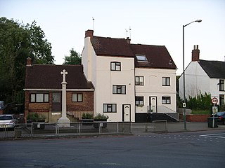
Keresley is a suburban village and civil parish in the City of Coventry, West Midlands, England, about 4.5 miles (7 km) north of Coventry city centre and 3.5 miles (6 km) southwest of Bedworth. According to the 2001 census, the parish had a population of 791 falling to 713 at the 2011 Census, although the 2018 population was estimated at 783. Keresley and Keresley End are two separate areas; Keresley is in Coventry, while the slightly more rural Keresley End, also known as Keresley village or Keresley Newlands, is in Warwickshire, with the exception of Thompsons Road in the village, which lies within the Coventry boundary. The village features two grocers shops, two bus stops, a beauty salon, primary school, doctors surgery, a fish and chip shop, a small church, a post office, library, park, garden centre and community centre.

<span class="mw-page-title-main">Highfield Road</span> Football stadium in Coventry, England

Highfield Road was a football stadium in the city of Coventry, England. It was the home ground for Coventry City F.C. for 106 years.

Ash Green is a suburban village in the Nuneaton and Bedworth district of Warwickshire, England.

<span class="mw-page-title-main">Exhall</span> Suburb in Warwickshire, England

Exhall is a suburban settlement and former civil parish, now in the unparished area of Bedworth, in the Nuneaton and Bedworth district of Warwickshire, England.

<span class="mw-page-title-main">Radford, Coventry</span> Human settlement in England

Radford is a suburb and electoral ward of Coventry, located approximately 1.5 miles north of Coventry city centre. It is covered by the Coventry North West constituency.

<span class="mw-page-title-main">Foleshill</span>

Foleshill is a suburb in the north of Coventry in the West Midlands of England. Longford, Courthouse Green and Rowley Green are to its north and Keresley is to its west. The population of the Ward at the 2011 census was 19,943.

Hillfields is a suburb of Coventry in the West Midlands of England. It is situated north of Coventry city centre, and has undergone a series of name changes throughout its history originally called "Harnall" and has seen itself change from a village, to a remote suburb, to a large postwar redevelopment zone.

<span class="mw-page-title-main">Cardinal Newman Catholic School and Community College</span> Academy in Coventry, West Midlands, England

Cardinal Newman Catholic School is a coeducational Roman Catholic secondary school and sixth form located in the Keresley area of Coventry, West Midlands, England. It is part of the Holy Cross Catholic MAC (HCCMAC).

Whitmore Park is a large residential suburb of Coventry, situated in the north of the city and bordering the suburbs of Keresley, Holbrooks, and Radford. It is served by Whitmore Park and Holy Family RC primary schools, with pupils then attending President Kennedy Comprehensive School or Cardinal Newman RC School for secondary education.

<span class="mw-page-title-main">Keresley End</span>

Keresley End is a village in the Nuneaton & Bedworth District of Warwickshire, England, also known as Keresley Village or Keresley Newlands. Population details can be found under Exhall. It is situated approximately 1.5 km north of Keresley, a suburb of Coventry, and, being close to the former Keresley colliery, it was where many coal miners lived.

Little Heath is an area of Coventry, in the county of West Midlands, in England. Most of the Little Heath area is in the Longford ward of the city.

The Warwickshire Coalfield extends between Warwick and Tamworth in the English Midlands. It is about 25 miles (40 km) from north to south and its width is around half that distance. Its western margin is defined by the 'Western Boundary Fault'. In the northeast it abuts against steeply dipping shales of Cambrian age. The larger part of the outcrop at the surface consists of the Warwickshire Group of largely coal-barren red beds. Until its closure in 2013, the Daw Mill mine near Arley within the coalfield, was Britain's biggest coal-producer in the 21st century.

Coventry Colliery was a coal mine located in the village of Keresley End in northern Warwickshire, between Bedworth and Coventry, England. Closed in 1991, the site today has been redeveloped as a distribution park, owned by Prologis.

Lythalls Lane Stadium was a greyhound racing and Motorcycle speedway stadium in Coventry. It is sometimes referred to as Foleshill Stadium or Coventry Stadium but should not be confused with Brandon Stadium.

References

  1. Macalister, Terry (8 December 2008). "Colliery on track for record output shows King Coal is striving to regain crown". The Guardian. Retrieved 20 February 2009.
  2. Taylor, Matthew (7 March 2013). "Daw Mill colliery closure marks end of an era for 650 miners". The Guardian. Retrieved 9 October 2015.

Coordinates: 52°26′35″N1°30′32″W / 52.443°N 1.509°W / 52.443; -1.509