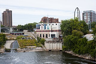
NSP/Xcel renewed its license which was authorized by the Federal Energy Regulatory Commission in March 2004. One condition of the license is the creation of a recreation area to show the evolution of St. Anthony Falls. A portion of the island overlooking the falls has been made into Water Power Park, allowing the closest possible approaches to the falls. In 2008, NSP/Xcel collaborated with the University of Minnesota's St. Anthony Falls Laboratory on 'StreamLab', an 'experimental stream channel and floodplain system'[3] which improves two existing flood bypass channels to study the site's ecology and hydrology.[1]
Crown Hydro, LLC, has proposed another hydro plant for the falls, to be built on the opposite bank of the Mississippi next to the Stone Arch Bridge.[5]
Notes
1 2 Xcel Energy, (2006), St. Anthony Hydro Project (PDF)
Saint Anthony Falls, or the Falls of Saint Anthony, located at the northeastern edge of downtown Minneapolis, Minnesota, was the only natural major waterfall on the Mississippi River. Throughout the mid-to-late 1800s, various dams were built atop the east and west faces of the falls to support the milling industry that spurred the growth of the city of Minneapolis. In 1880, the central face of the falls was reinforced with a sloping timber apron to stop the upstream erosion of the falls. In the 1950s, the apron was rebuilt with concrete, which makes up the most visible portion of the falls today. A series of locks were constructed in the 1950s and 1960s to extend navigation to points upstream.
Louis Hennepin, OFM was a Belgian Catholic priest and missionary best known for his activities in North America. A member of the Recollects, a minor branch of the Franciscans, he travelled to New France and proselytised to several Native American tribes.
The Stone Arch Bridge is a former railroad bridge crossing the Mississippi River at Saint Anthony Falls in downtown Minneapolis, Minnesota. It is the only arched bridge made of stone on the entire Mississippi River. It is the second oldest bridge on the river next to Eads Bridge. The bridge was built to connect the railway system to the new Union Depot, which at that time was planned to be built between Hennepin Avenue and Nicollet Avenue. The bridge was completed in 1883, costing $650,000 at the time. 117 Portland Avenue is the general address of the historic complex.
Northern States Power Company (NYSE: NSP) was a publicly traded S&P 500 electric and natural gas utility holding company based in Minneapolis, Minnesota, that is now a subsidiary of Xcel Energy.
Nicollet Island is an island in the Mississippi River just north of Saint Anthony Falls in central Minneapolis, Minnesota. According to the United States Census Bureau the island has a land area of 194,407 square metres (0.075 sq mi) and a 2000 census population of 144 persons. The island makes up a large part of the city-designated Nicollet Island/East Bank neighborhood. The island is named for cartographer Joseph Nicollet, who mapped the Upper Mississippi in the 1830s.
The Prairie Island Nuclear Generating Plant is an electricity-generating facility located in Red Wing, Minnesota, along the Mississippi River, and adjacent to the Prairie Island Indian Community reservation.
The Monticello Nuclear Generating Plant is a nuclear power plant located in Monticello, Minnesota, along the Mississippi River. The site, which began operating in 1971, has a single nuclear reactor of the General Electric BWR-3 design generating 671 MWe. The plant is owned by Xcel Energy and operated by Northern States Power, its regional subsidiary.
The Pillsbury A-Mill is a former flour mill located on the east bank of the Mississippi River in Minneapolis, Minnesota. It was the world's largest flour mill for 40 years. Completed in 1881, it was owned by the Pillsbury Company and operated two of the most powerful direct-drive waterwheels ever built, each capable of generating 1,200 horsepower . In 1901 one of the turbines was replaced with a 2,500 horsepower one. Both the mill and its headrace tunnel are contributing resources to the St. Anthony Falls Historic District, which is listed on the National Register of Historic Places. The mill is also independently on the NRHP. The mill was named a National Historic Landmark in 1966 and has since been converted into the A-Mill Artist Lofts.
Ford Dam, officially known as Lock and Dam No. 1, is on the Upper Mississippi River and is located between Minneapolis and Saint Paul, Minnesota just north of the confluence of the Mississippi with the Minnesota River at Mississippi River mile 847.9, in Minneapolis. The powerhouse portion was previously owned by the Ford Motor Company, which operated a hydroelectric power station to feed electricity to its Twin Cities Assembly Plant on the east side of the river. It was sold to Brookfield Power Co. in April 2008. The dual-lock facility and dam was built and is operated by the St. Paul district of the U.S. Army Corps of Engineers' Mississippi Valley Division.
The Ames Hydroelectric Generating Plant, constructed in 1890 near Ophir, Colorado, was one of the first commercial system to produce and transmit alternating current (AC) electricity for industrial use and one of the first AC hydro-electric plants ever constructed. It became operational in 1891 and was built by Westinghouse Electric around two of their large alternators. One was set up in the valley as a generator and driven by water. It was connected by a 2.6-mile (4.2 km) transmission line to the second alternator used as a motor up at the Gold King Mine to drive the mining operation. The facility has been changed and upgraded over the years but is still in operation. It is now on the List of IEEE Milestones.
Minneapolis is the largest city by population in the U.S. state of Minnesota, and the county seat of Hennepin County. The origin and growth of the city was spurred by the proximity of Fort Snelling, the first major United States military presence in the area, and by its location on Saint Anthony Falls, which provided power for sawmills and flour mills.
The Southeast Steam Plant, formerly known as the Twin City Rapid Transit Company Steam Power Plant, is a combined heat and power plant on the Mississippi River in the city of Minneapolis, Minnesota in the United States owned by the University of Minnesota.
Franklin Steele was an early settler of Minneapolis, Minnesota. Born in Chester County, Pennsylvania, of Scottish descent, Steele worked in the Lancaster, Pennsylvania, post office as a young man, where he once met President James Buchanan.
The following are all the contributing resources to the Saint Anthony Falls Historic District in Minneapolis, Minnesota, United States. The District is listed on the National Register of Historic Places, thus these properties are on the NRHP. The "period of significance" of the District was 1858–1941. The district's archaeological record is considered to be one of the most-endangered historic sites in Minnesota.
The Eastman tunnel, also called the Hennepin Island tunnel, was a 2,000-foot-long (600 m) underground passage in Saint Anthony, Minnesota, dug beneath the Mississippi River riverbed between 1868 and 1869 to create a tailrace so water-powered business could be located upstream of Saint Anthony Falls on Nicollet Island. The tunnel ran downstream from Nicollet Island, beneath Hennepin Island, and exited below Saint Anthony Falls.
The Saint Anthony Falls Laboratory, or SAFL, is a research laboratory situated on Hennepin Island in the Mississippi River in Minneapolis, Minnesota, United States. Its primary research is in "Engineering, Environmental, Biological, and Geophysical Fluid Mechanics". It is affiliated with the University of Minnesota's College of Science and Engineering. Research is conducted by graduate students and faculty alike using the 16,000 square feet of research space and 24 different specialized facilities.
Saint Croix Falls Dam, also known as St. Croix Falls Dam, is a hydroelectric dam on the St. Croix River between St. Croix Falls, Wisconsin and Taylors Falls, Minnesota. The only hydroelectric dam on the St. Croix River, it is operated by Xcel Energy.
St. Anthony Falls in Minneapolis, Minnesota, is the only natural falls on the Mississippi River. Since almost the beginning of settlement in the area by European descendants, the St. Anthony Falls have been used for waterpower. The first allowed settlers were at Ft. Snelling, where construction began in 1820. A sawmill was operating 1821 and a flour mill in 1823. As soon as the land at the sides of the falls became available it was purchased with the intent of using the waterpower of the falls. First lumber mills covered the falls, cutting lumber floated down the Mississippi. After 1870 flour mills started to dominate the area. From 1880 to 1930 the area was the number one flour producer in the US. In later years, some of the power came from steam, but in 1923 half of the waterpower used was for flour milling. Other industries have also used the waterpower.
This page is based on this Wikipedia article Text is available under the CC BY-SA 4.0 license; additional terms may apply. Images, videos and audio are available under their respective licenses.