Sans Souci is a census-designated place (CDP) in Greenville County, South Carolina, United States. The population was 7,869 at the 2010 census. It is part of the Greenville-Anderson-Mauldin, SC Metropolitan Statistical Area.
Wade Hampton is a census-designated place (CDP) in Greenville County, South Carolina, United States. The population was 20,622 at the 2010 census. It is named for American Civil War general and South Carolina governor Wade Hampton.

Easley is a city in Pickens County in the State of South Carolina. It is a principal city of the Greenville–Mauldin–Easley Metropolitan Statistical Area. Most of the city lies in Pickens County, with only a very small portion of the city in Anderson County.

Pickens, formerly called Pickens Courthouse, is a city in Pickens County, South Carolina, United States. The population was 3,126 at the 2010 census. Pickens changed its classification from a town to a city in 1998, but it was not reported to the Census Bureau until 2001. It is the county seat of Pickens County. It was named after Andrew Pickens (1739–1817), an American revolutionary soldier and US Congressman for South Carolina.

Piedmont is a census-designated place (CDP) along the Saluda River in Anderson and Greenville counties in the U.S. state of South Carolina. The population was 5,103 at the 2010 census.

The Peace Center is a performing arts center located in Greenville, South Carolina. It is composed of a concert hall, theater, and amphitheatre. It is located adjacent to Falls Park. It hosts over 300 events each year, including classical music, Broadway shows, and appearances by popular artists such as David Copperfield.

The Upstate is the region in the westernmost part of South Carolina, United States, also known as the Upcountry, which is the historical term. Although loosely defined among locals, the general definition includes the ten counties of the commerce-rich I-85 corridor in the northwest corner of South Carolina. This definition coincides with the Greenville–Spartanburg–Anderson, SC Combined Statistical Area, as first defined by the Office of Management and Budget in 2015, and maintained as of 2017. The region's population was 1,347,112 as of 2016. Situated between Atlanta and Charlotte, the Upstate is the fastest-growing region of South Carolina, and is the geographical center of the Charlanta mega-region. After BMW's initial investment, foreign companies, including others from Germany, have a substantial presence in the Upstate; several large corporations have established regional, national, or continental headquarters in the area. Greenville is the largest city in the region with a population of 67,453 and an urban-area population of 400,492, and it is the base of most commercial activity. Spartanburg and Anderson are next in population.
Greenville Memorial Auditorium was a 7,500-seat multi-purpose arena built in 1958 that was located in Greenville, South Carolina. It hosted local sporting events, concerts and the Ringling Brothers Circus until the Bi-Lo Center opened in 1998.
Greenville Municipal Stadium is a stadium in Greenville, South Carolina, USA, that was built in 1984 and holds 7,048 people. It is located on Mauldin Road off exit 46C on I-85.

The 4th Congressional District of South Carolina is a congressional district in upstate South Carolina bordering North Carolina. It includes parts of Greenville and Spartanburg counties. The district is characterized by the two major cities of Greenville and Spartanburg.

Area code 864 is an area code in the U.S. state of South Carolina that covers Greenville, Spartanburg, Anderson and the other parts of upstate South Carolina. It was split from area code 803 on December 3, 1995.
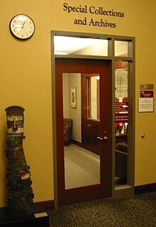
The South Carolina Baptist Historical Collection at Furman University is a comprehensive archives that documents individuals, churches, and associations in South Carolina Baptist history. Located in Greenville, South Carolina, it is housed in the Special Collections and Archives department of the James B. Duke Library.

Glassy Mountain is a mountain close to Pickens, South Carolina, USA, in Northwestern South Carolina, with a summit elevation of 1647 feet above mean sea level. While it is an isolated monadnock, it is still close to the Blue Ridge, providing views of nearby summits such as Table Rock and Caesar's Head as well as Greenville. The mountain gets its name from a large, bare, granite face on its North side. At the top of this rock face are small springs that trickle down the mountain, giving it a "glassy" appearance in the sun. It is easily accessible, as a small service road for transmitter towers leads to the summit. Local high-schoolers often paint the rock face with graduation years. These year numbers can be so large as to be seen on aerial imaging of the mountain
East Park is a neighborhood in Greenville, South Carolina. It is located immediately north to, and adjacent of, the downtown business district. This neighborhood is part of the East Park Avenue Historic District that was listed in the National Register of Historic Places in October 2005.
Hampton Pinckney is a neighborhood located in Greenville, South Carolina. One of the oldest neighborhoods in Greenville, it was where the textile industry was started in the early 19th century and lasted until the 1920s. The first trolley car in Greenville was installed in this neighborhood in 1899, opening for business in 1901.
North Main is a neighborhood in Greenville, South Carolina located near the downtown area. One of the oldest neighborhoods in the city, it was founded 1813 as a business location. Residential usage was expanded in 1896-7 that continued until the 1920s. Growth was slowed during the Great Depression, and slowed even further when US 29 began being built in the 1930s between Greenville and Spartanburg and was finally opened in 1946 following construction being halted to World War II.
Overbrook is a neighborhood in Greenville, South Carolina. It is a neighborhood built in 1913 upon expansion of the trolley line that was extended into the area three years earlier. Bungalow homes were built in this area from 1913 to 1924. Overbrook was developed by the Woodside brothers, who had made their fortunes managing the Woodside Cotton Mill, at one point the largest textile plant in the World.

West End is a neighborhood in Greenville, South Carolina. Located across the Reedy River in downtown, the west end became home to Furman University when it was first established in 1852. The school expanded to fill fifty acres and then moved to its current location northwest of the city in 1958. The Greenville and Columbia Railroad arrived there in 1853, bringing increased commercial activity to the neighborhood that had been first settled in the 1830s.
The French Bilingual School of South Carolina is an overseas French school in Wade Hampton in unincorporated Greenville County, South Carolina, in the Greenville-Spartanburg area. The school serves Kindergarten through the 12th grade and uses the curriculum of the French Ministry of Education. The elementary section includes grades K4-5, the middle section includes grades 6-9, and the high school section is 10-12. Michelin opened and operates the school for its employees working in South Carolina. For that reason it is also known as the Michelin French School. French expatriate families who do not work for Michelin are required to pay tuition.

Cleveland Park is the largest park in Greenville, South Carolina, much of its more than 120 acres being greenway along Richland Creek and the Reedy River near the city's "most elegant neighborhoods."