Herluf Trolle Land

Last updated
Herluf Trolle Land
Greenland.A2004208.1810.250m.jpg
NASA image of far Northern Greenland.
Greenland edcp location map.svg
Red pog.svg
Herluf Trolle Land
Geography
Location Peary Land, Greenland
Coordinates 82°30′N23°00′W / 82.500°N 23.000°W / 82.500; -23.000
Adjacent to Independence Fjord
Wandel Sea
G.B. Schley Fjord
Length60 km (37 mi)
Width50 km (31 mi)
Highest elevation914 m (2999 ft)
Highest pointUnnamed
Administration
Greenland (Denmark)
Demographics
PopulationUninhabited

Herluf Trolle Land is an area in Peary Land, North Greenland. Administratively it is part of the Northeast Greenland National Park. [1] [2]

Contents

The area has two clearly defined parts: Herlufsholm Strand, the flat southeasterly point of Peary Land, and the easternmost mountainous hinterland of the peninsula which rises to the north of Independence Fjord. [2]

History

There are ancient archaeological remains in the area, including the frame of a 10.6 metres (35 ft) long umiak and a number of camping grounds with abandoned utensils, that were found at excavations in Herlufsholm Strand. This coastal zone may be the first place of the eastward spreading of the early Arctic Whale Hunting Culture from Alaska. [3]

In 1900 Robert Peary discerned Cape Clarence Wyckoff, a broad headland on the northeastern shore of Herluf Trolle Land, from Wyckoff Island, a place by the shore which Peary mistook for an island. It was the farthest point that he reached after rounding the northern end of Greenland. [4]

The coast south of this cape was explored by J.P. Koch in the course of the 1906-08 Danmark Expedition and was named after historical Danish mariner Herluf Trolle (1516 – 1565). Later it would be mapped accurately by Lauge Koch by means of surveys that he undertook during the Danish Bicentenary Jubilee Expedition in 1920-23 and the cartographic air expedition of 1938. [5]

Geography

Herluf Trolle Land is located in southeastern Peary Land, on the northern side of the mouth area of the Independence Fjord. The limits of the territory are not clearly defined. To the west it is bounded by Melville Land, and to the north by the G.B. Schley Fjord. [5]

Herluf Trolle Land is the mountainous sector located to the west of Herlufsholm Strand. There are several low mountain ranges in the northeastern portion of the territory and two small ice caps. In the north a mountainous plateau rises to a height of 914 metres (2,999 ft) and 853 metres (2,799 ft) high Mount Clarence Wyckoff rises near Hellefisk Fjord. Except for these heights the area is largely ice-free. The plains bordering the mountain zone are crossed by numerous rivers. [6] [5]

Herlufsholm Strand

The coastal zone is known as Herlufsholm Strand, a broad, low-lying strip of land between the Wandel Sea shore to the east and the mountains of the interior to the west. It extends between Cape Eigil Knuth (Kap København) and Cape Henry Parish, with Cape Eiler Rasmussen as the easternmost point. Mudder Bay (Mudderbugten), a 9.2 kilometres (30,184 ft) wide, open bay, is located near the southern limit by Cape Eigil Knuth. The sea facing the Herlufsholm Strand shore is frozen throughout the entire year. Mount Henry Parish rises near the northern end and Kjovesletten is a coastal flatland that lies to the southwest. There are muskoxen in the area. [6] [1] [7]

Johan Peter Koch map of NE Greenland showing the location of Herlufsholm Strand. Karte Nordostgronland Koch 1911.png
Johan Peter Koch map of NE Greenland showing the location of Herlufsholm Strand.

Bibliography

See also

Related Research Articles

<span class="mw-page-title-main">Peary Land</span> Peninsula in northern Greenland

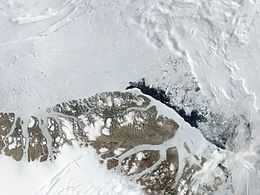
Peary Land is a peninsula in northern Greenland, extending into the Arctic Ocean. It reaches from Victoria Fjord in the west to Independence Fjord in the south and southeast, and to the Arctic Ocean in the north, with Cape Morris Jesup, the northernmost point of Greenland's mainland, and Cape Bridgman in the northeast.

Brønlundhus, on some maps also Brønlundfjord, is a former research station and radio station located on the western shore of Jørgen Brønlund Fjord in southern Peary Land, in northern Greenland. It is named after Greenlandic Arctic researcher Jørgen Brønlund, or after the namesake fjord on which it is located. It is close to the mouth of Jørgen Brønlund Fjord where it opens into Independence Fjord.

Count Eigil Knuth was a Danish explorer, archaeologist, sculptor and writer. He is referred to as the Nestor of Danish polar explorers. His archaeological investigations were made in Peary Land and adjacent areas of High Arctic Greenland. Knuth was made a Knight of the Dannebrog.

<span class="mw-page-title-main">Frederick E. Hyde Fjord</span>

Frederick E. Hyde Fjord is a fjord in Peary Land, far northern Greenland.

<span class="mw-page-title-main">Cape Bridgman</span>

Cape Bridgman is a headland in the Wandel Sea, Arctic Ocean, northeast Greenland.

<span class="mw-page-title-main">G.B. Schley Fjord</span>

G.B. Schley Fjord is a fjord in Peary Land, northern Greenland. To the east, the fjord opens into the Wandel Sea of the Arctic Ocean.

<span class="mw-page-title-main">Hellefisk Fjord</span>

Hellefisk Fjord is a fjord in Peary Land, northern Greenland. To the northeast, the fjord opens into the Wandel Sea of the Arctic Ocean.

<span class="mw-page-title-main">Sands Fjord</span> Fjord in northern Greenland

Sands Fjord is a fjord in Peary Land, northern Greenland. To the north, the fjord opens into the Lincoln Sea of the Arctic Ocean. Administratively, it belongs to the Northeast Greenland National Park.

<span class="mw-page-title-main">Nordkrone</span> Mountain in Greenland

Nordkrone is a mountainous area in Peary Land, Northern Greenland. Administratively it is part of the Northeast Greenland National Park.

<span class="mw-page-title-main">Roosevelt Range</span>

The Roosevelt Range or Roosevelt Mountains is a mountain range in Northern Greenland. Administratively this range is part of the Northeast Greenland National Park. Its highest peak is the highest point in Peary Land.

<span class="mw-page-title-main">Frigg Fjord</span>

Frigg Fjord is a fjord in Peary Land, far northern Greenland.

<span class="mw-page-title-main">Johannes V. Jensen Land</span> Region in Northeast Greenland National Park, Greenland

Johannes V. Jensen Land is an area in Peary Land, Northern Greenland. Administratively it lies in the Northeast Greenland National Park zone. The area is remote and currently uninhabited.

<span class="mw-page-title-main">Navarana Fjord</span>

Navarana Fjord is a fjord in Peary Land, far northern Greenland. It is named after an Inuit woman.

<span class="mw-page-title-main">Wyckoff Land</span>

Wyckoff Land is an area or peninsula in Peary Land, Northern Greenland.

<span class="mw-page-title-main">Cape Clarence Wyckoff</span>

Cape Clarence Wyckoff, also known as Cape Wyckoff, is a broad headland in the Wandel Sea, Arctic Ocean, northernmost Greenland. Administratively it is part of the Northeast Greenland National Park.

<span class="mw-page-title-main">Cape Henry Parish</span>

Cape Henry Parish is a broad headland in the Wandel Sea, Arctic Ocean, northernmost Greenland. Administratively it is part of the Northeast Greenland National Park.

<span class="mw-page-title-main">Gertrud Rask Land</span>

Gertrud Rask Land is an area in Peary Land, North Greenland. Administratively it is part of the Northeast Greenland National Park.

<span class="mw-page-title-main">Melville Land</span>

Melville Land is an area in Peary Land, North Greenland. Administratively it is part of the Northeast Greenland National Park.

<span class="mw-page-title-main">Cape Eiler Rasmussen</span>

Cape Eiler Rasmussen is a broad headland in the Wandel Sea, Arctic Ocean, northernmost Greenland. Administratively it is part of the Northeast Greenland National Park.

<span class="mw-page-title-main">Mount Clarence Wyckoff</span> Mountain in Peary Land, Greenland

Mount Clarence Wyckoff is a mountain in Peary Land, Northern Greenland. Administratively the mountain belongs to the Northeast Greenland National Park.

References