
The Cuban Revolutionary Armed Forces are the military forces of Cuba. They include Revolutionary Army, Revolutionary Navy, Revolutionary Air and Air Defense Force, and other paramilitary bodies including the Territorial Troops Militia, Youth Labor Army, and the Defense and Production Brigades, plus the Civil Defense Organization and the National Reserves Institution. All these groups are subordinated to the Ministry of the Revolutionary Armed Forces.

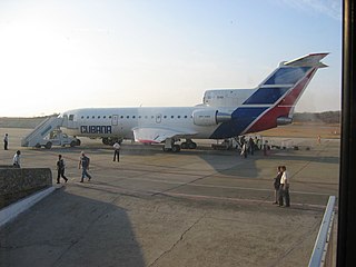
José Martí International Airport, sometimes known by its former name Rancho Boyeros Airport, is an international airport located 20 kilometres (12 mi) southwest of the centre of Havana, Cuba, and is a hub for Cubana de Aviación and Aerogaviota, and former Latin American hub for the Soviet airline Aeroflot. It is Cuba's main international airport, and serves several million passengers each year. The facility is operated by Empresa Cubana de Aeropuertos y Servicios Aeronáuticos (ECASA).

The United States invasion of Grenada began at dawn on 25 October 1983. The United States and a coalition of six Caribbean nations invaded the island nation of Grenada, 100 miles (160 km) north of Venezuela. Codenamed Operation Urgent Fury by the U.S. military, it resulted in military occupation within a few days. It was triggered by the strife within the People's Revolutionary Government, which resulted in the house arrest and execution of the previous leader and second Prime Minister of Grenada, Maurice Bishop, and the establishment of the Revolutionary Military Council, with Hudson Austin as chairman. The invasion resulted in the appointment of an interim government, followed by elections in 1984.

Varadero, also referred to as Playa Azul, is a resort town in the province of Matanzas, Cuba, and one of the largest resort areas in the Caribbean. Varadero Beach is rated one of the world's best beaches in TripAdvisor's Traveler's Choice Awards since 2019, ranking at number 9 as of January 2024. Common activities include fishing and excursions to Matanzas, Cárdenas, and the Península de Zapata.

Guantánamo is a municipality and city in southeast Cuba and capital of Guantánamo Province.
Antonio Maceo Airport is an international airport located in Santiago, Cuba.

Cayo Coco (Cays) or is an island on the north coast of central Cuba, known for its all-inclusive resorts. It lies within the Ciego de Ávila Province and is part of a chain of islands called Jardines del Rey. The cay is administered by the Morón municipality, has a surface area of 370 km2, and is named after the white ibis, locally called coco (coconut) birds. The island is known for its long beaches and many resort hotels.

Jardines del Rey Airport is an airport situated on the island of Cayo Coco, part of the Cuban province of Ciego de Ávila. It takes its name from the Jardines del Rey archipelago, which includes Cayo Coco. Inaugurated in December 2002, the airport was built to better serve tourists to the island, who previously had to arrive at Máximo Gómez Airport about 70 kilometres (43 mi) to the south. Jardines del Rey Airport is the only airport in Cuba managed in part by a foreign company; Aena and ECASA jointly operate the airport. It receives well over 200,000 passengers per year, most of whom are foreign tourists from Canada.

Las Tunas is a city and municipality in central-eastern Cuba. It is the capital of the Las Tunas Province and was named Victoria de Las Tunas from 1869 to 1976.

Sunwing Airlines Inc. is a Canadian low-cost airline headquartered in Toronto, Ontario. On May 1, 2023, WestJet announced that it had completed the acquisition of Sunwing Airlines.

Juan Gualberto Gómez Airport, formerly known as Varadero Airport, is an international airport serving Varadero, Cuba, and the province of Matanzas. The airport is located 5 km from the village of Carbonera, closer to the city of Matanzas than to Varadero. The closest airport to Varadero is Kawama Airport. In 2009, the airport handled 1.28 million passengers, making it the second busiest airport in Cuba after José Martí International Airport in Havana.

Boyeros is one of the 15 municipalities or boroughs in the city of Havana, Cuba. The municipality was created in 1976, and amalgamated the town of Santiago de Las Vegas. It lies on the south-west side of the city and includes José Martí International Airport.

Frank País Airport is an airport serving Holguín, a city in the Cuban province of Holguín. It bears the name of Cuban revolutionary Frank País. The airport was built in 1962 initially only for military purposes before civilian air operations began in 1966. It consists of a domestic and an international terminal, which was built in 1996 and expanded in 2007.

Ignacio Agramonte International Airport is an international airport in central Camagüey Province, Cuba. It serves the city of Camagüey and the resort village of Santa Lucía.

Abel Santamaría Airport is an international airport serving Santa Clara, the capital city of the Villa Clara Province in Cuba. It was named after the Cuban revolutionary Abel Santamaría. The airport is the main entry point for tourists travelling to Cayo Santa María and the other keys on the northern coast of the province.
Ciudad Libertad Airport is a defunct airport near Havana, Cuba. and formerly known as El Aeropuerto de Columbia. Located in the borough of Playa, it was Cuba's main airport until 1930, when it was replaced by José Martí International Airport. The airport was also the location of the 1960 Cuban Grand Prix. Two days prior to the Bay of Pigs Invasion in 1961 the airport was bombed by US planes. It previously had two runways, but only one remains. It is now a school.
Visitors to Cuba must obtain a visa before travel or a tourist card from one of the Cuban diplomatic missions, travel agencies or authorized airlines unless they come from one of the visa exempt countries.
Managua Airport is a military airport based 17 kilometres (11 mi) south of Havana, the capital of Cuba, on the border between Havana and Mayabeque provinces.
