Hermosa Beach Pier

Last updated

The Hermosa Beach Pier is located in the Southern California community of Hermosa Beach. It extends into the Pacific Ocean.

Contents
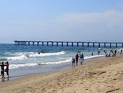
Hermosa Beach Pier in the summer of 2006 Hermosa beach summer day.jpg
Hermosa Beach Pier in the summer of 2006

In 1904 the first pier was built. It was constructed entirely of wood even to the pilings and it extended five hundred feet out into the ocean. The pier was constructed by the Hermosa Beach Land and Water Company. In 1913 this old pier was partly washed away and later torn down and a new one built to replace it. This pier was built of concrete 1,000 feet (300 m) long, and paved with asphalt its entire length. Small tiled pavilions were erected at intervals along the sides to afford shade for fishing and picnic parties. A bait stand was built eventually out on the end. Soon after, about 1914, an auditorium building was constructed; it has housed various enterprises and at present the public rest rooms, the Los Angeles Lifeguard Service, and the local branch of the LA County Library occupy rooms in the building. This pier is municipally owned.

The pier's frontage has changed in appearance over the years and electric train lines used to run along the coastline. [1]

Filming location

Film
TV

Related Research Articles

<span class="mw-page-title-main">Hermosa Beach, California</span> City in California, United States

Hermosa Beach is a beachfront city in Los Angeles County in the U.S. state of California, United States. Its population was 19,728 at the 2020 U.S. Census. The city is located in the South Bay region of the Greater Los Angeles area; it is one of the three Beach Cities. Hermosa Beach is bordered by the other two, Manhattan Beach to the north and Redondo Beach to the south and east.

<span class="mw-page-title-main">Manhattan Beach, California</span> City in California, United States

Manhattan Beach is a city in southwestern Los Angeles County, California, United States, on the Pacific coast south of El Segundo, west of Hawthorne and Redondo Beach, and north of Hermosa Beach. As of the 2020 census, the population was 35,506.

<span class="mw-page-title-main">Newport Beach, California</span> City in Orange County, California

Newport Beach is a coastal city of about 85,000 in southern Orange County, California, United States. Located about 40 miles (64 km) southeast of downtown Los Angeles, Newport Beach is known for its sandy beaches. The city's harbor once supported maritime industries. Today it is used mostly for recreation. Balboa Island draws visitors with a waterfront path and easy access from the ferry to the shops and restaurants.

<span class="mw-page-title-main">Seal Beach, California</span> City in California, United States

Seal Beach is a coastal city in Orange County, California, United States. As of the 2020 census, the population was 25,242, up from 24,168 at the 2010 census.

<span class="mw-page-title-main">Jersey Shore</span> Coastal region of the U.S. state of New Jersey

The Jersey Shore, commonly referred to locally as simply the Shore, is the coastal region of the U.S. state of New Jersey. Geographically, the term encompasses about 141 miles (227 km) of oceanfront bordering the Atlantic Ocean, from Perth Amboy in the north to Cape May Point in the south. The region includes Middlesex, Monmouth, Ocean, Atlantic, and Cape May counties, which are in the central and southern parts of the state. Located in the center of the Northeast Megalopolis, the northern half of the shore region is part of the New York metropolitan area, while the southern half of the shore region is part of the Philadelphia metropolitan area, also known as the Delaware Valley. The Jersey Shore hosts the highest concentration of oceanside boardwalks in the United States.

<span class="mw-page-title-main">Santa Monica Bay</span> Bight in the Pacific Ocean

Santa Monica Bay is a bight of the Pacific Ocean in Southern California, United States. Its boundaries are slightly ambiguous, but it is generally considered to be the part of the Pacific within an imaginary line drawn between Point Dume, in Malibu, and the Palos Verdes Peninsula. Its eastern shore forms the western boundary of the Los Angeles Westside and South Bay regions. Although it was fed by the Los Angeles River until the river's catastrophic change of course in 1825, the only stream of any size now flowing into it is Ballona Creek. Smaller waterways draining into the bay include Malibu Creek, Topanga Creek, and Santa Monica Creek.

The history of Santa Monica, California, covers the significant events and movements in Santa Monica's past.

<span class="mw-page-title-main">Ocean View (Norfolk)</span> Region of Norfolk, Virginia, US

Ocean View is a coastal region in the independent city of Norfolk, Virginia in the United States. It has several miles of shoreline on the Chesapeake Bay to the north, starting with Willoughby Spit to the west and the Joint Expeditionary Base -- Little Creek in the independent city of Virginia Beach on the east.

<span class="mw-page-title-main">San Pedro Bay (California)</span> Bay near Los Angeles in California, United States

San Pedro Bay is an inlet on the Pacific Ocean coast of southern California, United States. It is the site of the Port of Los Angeles and the Port of Long Beach, which together form the fifth-busiest port facility in the world and the busiest in the Americas. The Los Angeles community of San Pedro borders a small portion of the western side of the bay. The city of Long Beach borders the port on the eastern side of the bay. The northern part of the bay, which is the largest part of the port, is bordered by the Los Angeles neighborhood of Wilmington.

<span class="mw-page-title-main">Balboa Pavilion</span> United States historic place

The Balboa Pavilion in Newport Beach, Orange County, California, is a California Historical Landmark and a National Historic Place. Established on July 1, 1906, the Balboa Pavilion played a prominent role in the development of Newport Beach by attracting real estate buyers to an area formerly designated as "swamp and overflow" land.

<span class="mw-page-title-main">Port of San Francisco</span> Organization that oversees port facilities in San Francisco, California, United States

The Port of San Francisco is a semi-independent organization that oversees the port facilities at San Francisco, California, United States. It is run by a five-member commission, appointed by the Mayor and approved by the Board of Supervisors. The Port is responsible for managing the larger waterfront area that extends from the anchorage of the Golden Gate Bridge, along the Marina district, all the way around the north and east shores of the city of San Francisco including Fisherman's Wharf and the Embarcadero, and southward to the city line just beyond Candlestick Point. In 1968, the State of California, via the California State Lands Commission for the State-operated San Francisco Port Authority, transferred its responsibilities for the Harbor of San Francisco waterfront to the City and County of San Francisco / San Francisco Harbor Commission through the Burton Act AB2649. All eligible State port authority employees had the option to become employees of the City and County of San Francisco to maintain consistent operation of the Port of San Francisco.

<span class="mw-page-title-main">Fisherman's Village</span> Tourist attraction in Marina del Rey, California, USA

Fisherman's Village is a waterfront mall, commercial boat anchorage and tourist attraction located in the world's largest man-made small boat harbor in Los Angeles County at Marina del Rey, California. The Ballona Wetlands State Ecological Reserve is just east of Fisherman's Village and immediately to the south is the federally-owned riverine estuary of Ballona Creek. The historical Fisherman's Village, built in 1967, is nestled on the eastern bank of main harbor entrance channel between Whiskey Reds restaurant to the south and the Windward boatyard to the north.

<span class="mw-page-title-main">Huntington Beach Pier</span> United States historic place

The Huntington Beach Pier is a municipal pier located in Huntington Beach, California, at the west end of Main Street and west of Pacific Coast Highway. At 1,850 ft (560 m) in length, it is one of the longest public piers on the West Coast of the United States. The deck of the pier is 30 ft (9.1 m) above sea level, while the top of the restaurant structure at the end of the pier is 77 ft (23 m).

<span class="mw-page-title-main">Pier Village</span>

Pier Village is a Victorian-inspired mixed-use community located in Long Branch, New Jersey along the Atlantic Ocean. It opened in 2005.

<span class="mw-page-title-main">Redondo Beach pier</span>

The Redondo Beach pier is located in Redondo Beach, California and stretches out into the Pacific Ocean. The pier has been rebuilt and altered by storms and redevelopments. Its official name is "Municipal Pier," and it has also been called the "Endless Pier".

<span class="mw-page-title-main">Alamitos Beach, Long Beach, California</span> Neighborhood in Long Beach, California, US

Alamitos Beach is a coastal neighborhood in the southern portion of the city of Long Beach, California. Although it was in unincorporated Los Angeles County when annexed by the City of Long Beach, it had been planned as its own community with a townsite.

<span class="mw-page-title-main">Lighthouse Café</span>

The Lighthouse Café is a nightclub located at 30 Pier Avenue in Hermosa Beach, California. It has been active as a jazz showcase since 1949 and, under the name "The Lighthouse", was one of the best known West Coast jazz clubs from the 1950s through the late 1970s. In addition to jazz, reggae to rock - among other genres of music - are now performed at the venue, including bookings of local artists such as Jett Prescott and George Stanford.

Peck's Pier was a wooden pier in Manhattan Beach, California, constructed in 1908 by George H. Peck, for whom it was named. Peck was a wealthy real estate developer who owned a lot of property in the area. The pier was located in the area of 33rd and 34th Street and was the only pier in the area open to African Americans.

<span class="mw-page-title-main">Beach Cities Greenway</span> Rail trail in Manhattan Beach and Hermosa Beach, California

The Beach Cities Greenway in Manhattan Beach and Hermosa Beach, California is a 3.9-mile (6.3 km) rail trail. The greenway is a linear park on the median between Valley Drive running along the west side and Ardmore Avenue on the east.

References

  1. "City of Hermosa Beach -- Pier Pictures -- City of Hermosa Beach, CA". www.hermosabch.org. Archived from the original on November 10, 2002.
  2. "THE O.C. Filming Locations" . Retrieved January 17, 2017.

See also

33°51′41″N118°24′14″W / 33.8615°N 118.4038°W / 33.8615; -118.4038