Herveld

Last updated
Herveld
Overzicht van de noordwestgevel met kerktoren - Herveld-Zuid - 20381451 - RCE.jpg
Church of Herveld
2010-NL-P05-Gelderland-positiekaart-gemnamen.jpg
Red pog.svg
Herveld
Location in the Netherlands
Netherlands location map.svg
Red pog.svg
Herveld
Herveld (Netherlands)
Coordinates: 51°54′N5°45′E / 51.900°N 5.750°E / 51.900; 5.750 Coordinates: 51°54′N5°45′E / 51.900°N 5.750°E / 51.900; 5.750
Country Netherlands
Province Gelderland
Municipality Overbetuwe
Area
[1]
  Total11.25 km2 (4.34 sq mi)
Elevation
[2]
8 m (26 ft)
Population
 (2021) [1]
  Total3,075
  Density270/km2 (710/sq mi)
Time zone UTC+1 (CET)
  Summer (DST) UTC+2 (CEST)
Postal code
6674 [1]
Dialing code 0488

Herveld is a village in the Dutch province of Gelderland. It is located in the municipality of Overbetuwe.

Herveld was a separate municipality until 1818, when the area was divided between Loenen en Wolferen and Valburg. [3]

The village exists of two semi-separate communities of Herveld-Noord and Herveld-Zuid., [4] connected by the Stenenkamerstraat. The mostly Catholic Herveld-North is located directly east of the village Andelst while the more Protestant Herveld-South is a mile further south. Most amenities such as supermarkets, are located in Herveld-North.

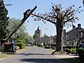
In the center of Herveld-South is a Gothic hall church, dating from the 15th century. Just outside the village is De Vink, a mill from the 18th century. Herveld is just off the A50 motorway (junction/knooppunt Valburg), and to come into the village, one must follow the A15.

Herveld has a rich history of fruit cultivation. [5]

Related Research Articles

Schin op Geul Village in Limburg, Netherlands

Schin op Geul is a village in the Dutch province of Limburg. It is located in the municipality of Valkenburg aan de Geul, about 3 km southeast of the town of Valkenburg.

Elsloo, Limburg Village in Limburg, Netherlands

Elsloo is a village in the Dutch province of Limburg. It is located in the municipality of Stein, about 2 km south of the town of Stein itself. Beek-Elsloo railway station serves Elsloo.

Spanbroek Small city in North Holland, Netherlands

Spanbroek is a small city in the Dutch province of North Holland. It is a part of the municipality of Opmeer, and lies about 9 km (6 mi) northwest of Hoorn.

Spaubeek Village in Limburg, Netherlands

Spaubeek is a village in the Dutch province of Limburg. It is located in the municipality of Beek, about 3 km south of the town of Geleen. Spaubeek was a separate municipality until 1982, when it was merged with Beek.

Valburg Village in Gelderland, Netherlands

Valburg is a village in the Dutch province of Gelderland. It is located in the municipality of Overbetuwe, about 10 km northwest of Nijmegen.

Vlijmen Town in North Brabant, Netherlands

Vlijmen is a town in the Dutch province of North Brabant. It is located in the municipality of Heusden, about 6 km west of 's-Hertogenbosch.

Kruiningen Village in Zeeland, Netherlands

Kruiningen is a village in the Dutch province of Zeeland. It is located in the municipality of Reimerswaal, about 5 km south of the village of Yerseke.

Brijdorpe is a hamlet in the Dutch province of Zeeland. It is a part of the municipality of Schouwen-Duiveland, and lies about 23 km southwest of Hellevoetsluis.

Elkerzee Hamlet in Zeeland, Netherlands

Elkerzee is a hamlet in the Dutch province of Zeeland. It is a part of the municipality of Schouwen-Duiveland, and lies about 1 km south of Scharendijke.

Looperskapelle Hamlet in Zeeland, Netherlands

Looperskapelle is a hamlet in the Dutch province of Zeeland. It is a part of the municipality of Schouwen-Duiveland, and lies about 23 km southwest of Hellevoetsluis.

Nieuwerkerke Hamlet in Zeeland, Netherlands

Nieuwerkerke is a hamlet in the Dutch province of Zeeland. It is a part of the municipality of Schouwen-Duiveland, and lies about 3 km southwest of Brouwershaven.

Achthoven, Montfoort Hamlet in Utrecht, Netherlands

Achthoven is a hamlet in the Dutch province of Utrecht. It is a part of the municipality of Montfoort, and lies about 6 km northwest of IJsselstein. Between 1818 and 1857, Achthoven was a separate municipality; it merged with Linschoten in 1857.

Jansgeleen Castle

Jansgeleen Castle, now erroneously called Sint-Jansgeleen or Sint Jansgeleen, was a medieval castle in the little village of Spaubeek, in the Dutch province of Limburg. Spaubeek is located in the municipality of Beek, about 3 km south of the town of Geleen. Spaubeek was a separate municipality until 1982, when it was merged with Beek.

Benthorn Hamlet in South Holland, Netherlands

Benthorn is a hamlet in the Dutch province of South Holland. It is located in the municipality of Alphen aan den Rijn, about 2 km east of the centre of Benthuizen.

Strevelshoek Hamlet in South Holland, Netherlands

Strevelshoek is a hamlet in the Dutch province of South Holland. It is located about 1 km northwest of the village of Rijsoord, on the south bank of the Waaltje. The hamlet is not mentioned on recent topographical maps.

Vrijhoeven is a former hamlet and former municipality in the Dutch province of South Holland. It is located about 2 km south of the village of Ter Aar.

De Stolpen is a hamlet in the Dutch province of North Holland. It is part of the municipality of Schagen, and is located about 3 km northwest of the village of Schagerbrug.

Bears, Friesland Village in Friesland, Netherlands

Bears or Beers is a small village in the Dutch province of Friesland. It is located in the municipality Leeuwarden, about 8 km southwest of Leeuwarden. Bears has a population of about 133 in January 2017.

Bern, Netherlands Hamlet in Gelderland, Netherlands

Bern is a hamlet in the Dutch province of Gelderland. It is located in the municipality of Zaltbommel, about 10 kilometres south of the town Zaltbommel.

Bosch is a hamlet in the Dutch province of North Brabant. It is located in the municipality of Cranendonck, about 1.5 km east of Budel.

References

  1. 1 2 3 "Kerncijfers wijken en buurten 2021". Central Bureau of Statistics. Retrieved 24 March 2022.
  2. "Postcodetool for 6674AA". Actueel Hoogtebestand Nederland (in Dutch). Het Waterschapshuis. Retrieved 24 March 2022.
  3. Ad van der Meer and Onno Boonstra, "Repertorium van Nederlandse gemeenten", KNAW, 2006. "KNAW > Publicaties > Detailpagina". Archived from the original on 2007-02-20. Retrieved 2009-12-03.
  4. ANWB Topografische Atlas Nederland, Topografische Dienst and ANWB, 2005.
  5. "Fruit- en boomteelt bundelen krachten tegen drinkwaterwinning". De Gelderlander (in Dutch). Retrieved 24 March 2022.