Related Research Articles

Hesse or Hessia, officially the State of Hesse, is a state of the Federal Republic of Germany. Its capital city is Wiesbaden, and the largest urban area is Frankfurt. With an area of 21,000 square kilometers and a population of just over six million it ranks seventh and fifth respectively among the sixteen German states. Frankfurt Rhine-Main, Germany's second-largest metropolitan area, is mainly located in Hesse.

The Rhön Mountains are a group of low mountains in central Germany, located around the border area where the states of Hesse, Bavaria and Thuringia come together. These mountains, which are at the extreme southeast end of the East Hesse Highlands, are partly a result of ancient volcanic activity. They are separated from the Vogelsberg Mountains by the river Fulda and its valley. The highest mountain in the Rhön is the Wasserkuppe which is in Hesse. The Rhön Mountains are a popular tourist destination and walking area.

Gladenbach [German pronunciation: [ˈɡlaːdn̩ˌbax](listen)] is a town in Hesse, Germany, in the west of Marburg-Biedenkopf district.
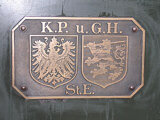
The Royal Prussian and Grand-Ducal Hessian State Railways was a state-owned network of independent railway divisions in the German states of Prussia and Hesse in the early 20th century. It was not, as sometimes maintained, a single state railway company.
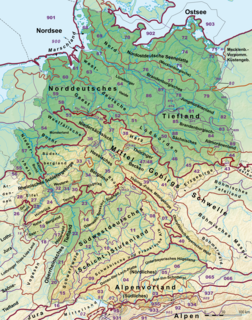
This division of Germany into major natural regions takes account primarily of geomorphological, geological, hydrological, and pedological criteria in order to divide the country into large, physical units with a common geographical basis. Political boundaries play no part in this, apart from defining the national border.

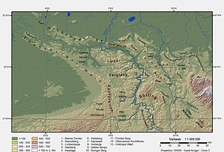
The West Hesse Highlands, also known as the West Hessian Lowlands and Highlands, refers to a heavily forested region of the Central Uplands in Germany that lies mostly within the state of Hesse, between those elements of the Rhenish Massif right of the Rhine in the west, the Weser Uplands to the north, the Hessian Central Uplands to the east and the Wetterau to the south.

The West Hesse Depression is part of the West Hesse Highlands and Lowlands region in the north of the German state of Hesse. Like the East Hesse Depression, it is a series of separate depressions that form a natural corridor and have been an important historical trade route.
The East Hesse Highlands describes a heavily wooded range of hills lying mainly in the German state of Hesse, but also extending a little way into Lower Saxony to the north, Thuringia to the east and Bavaria to the southeast. The region is sandwiched between the West Hesse Depression to the west, the Weser Uplands to the north, the Thuringian Basin to the northeast, the northwestern edge of the Thuringian Forest to the east, the Spessart to the south and the Wetterau to the southwest.

Heiligenberg is a mountain of Hesse, Germany. It is located between Altendorf to the north and Heimarshausen to the south of the Naumburgh township in the district of Kassel. It lies in the East Waldeck Border Lowlands of the West Hesse Highlands, and is covered with a mixed deciduous and evergreen forest. It lies within the Habichtswald Nature Park. The Elbe, a northern tributary of the Eder, runs east past the mountain.

The Hessian Skittles are a group of nine extinct volcanoes in the northwestern and lowest part of the Rhön Mountains in East Hesse, Germany. This striking collection of domed hills or kuppen is located in the counties of Hersfeld-Rotenburg and Fulda in the northwestern part of the Kuppen Rhön east of Eiterfeld and south of Schenklengsfeld.

The Hessian Ried is a low-lying, agricultural region that forms part of the northeastern area of the Upper Rhine Plain. It is situated in South Hesse in west central Germany.

The region of Middle Hesse is one of three planning regions in the German state of Hesse, alongside North and South Hesse. Its territory is identical with that of the administrative province of Gießen and covers the counties of Limburg-Weilburg, Lahn-Dill-Kreis, Gießen, Marburg-Biedenkopf and Vogelsbergkreis. The Middle Hesse Regional Assembly, which decides on the regional plan, currently consists of 31 members chosen by the five counties and the three towns with special status: Gießen, Marburg and Wetzlar. The regional assembly has tasked the governing president (Regierungspräsident) with delivering regional management. The Mid-Hesse Regional Management Association was founded on 22 January 2003.
The Schwalm is a natural region or landscape unit within the West Hesse Depression and also the smallest basin within it. It is named after the River Schwalm, on whose middle reaches it lies. In the east the Schwalm region is bounded by the Knüll hills, in the south by the northern foothills of the Vogelsberg and, in the west, by the Gilserberg Heights. In the north the Schwalm transitions into the Landsburg Basin.

The Upper Hessian Ridge or Upper Hesse Ridge is a hill chain in the West Hesse Highlands in North and Middle Hesse, which lies on the Rhine-Weser watershed and links the montane Central Upland ranges of the Kellerwald and the Vogelsberg in a north-south direction. The swell is divided into the Gilserberg Heights in the north, the central Neustadt Saddle and the Northern Vogelsberg Foreland in the south.

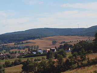
The Langenberg, also colloquially called the Langenberge (plural) due to its several and widely spaced hilltops, is a hill range of the German Central Uplands which covers an area of over 22 km² and reaches a height of 556.7 m above sea level (NHN) at the Schwengeberg. It is a natural region in the Habichtswald Highlands in the counties of Kassel and Schwalm-Eder-Kreis in North Hesse.
The Osnabrück Uplands, Osnabrück Hills or, less commonly, Osnabrück Hill Country, are the low hills, or Hügelland, rarely over 200 m above NHN, in the northwest of the Lower Saxon Hills near Osnabrück in Germany. They are bounded by the Wiehen Hills to the north and the Teutoburg Forest to the south. Regionally, especially in tourism, they are often referred to locally as the Osnabrücker Bergland, however this is usually not a precisely defined physical landscape, but refers to an area roughly comprising the municipal boundaries of Osnabrück and a narrow radius around the city. By contrast the natural region major unit known as the Osnabrücker Hügelland extends from north-west of Ibbenbüren to the Melle Hills north of Melle, behind which is their south-eastern continuation, the Ravensberg Hills.

The Vogelsberg (help·info) is a large volcanic mountain range in the German Central Uplands in the state of Hesse, separated from the Rhön Mountains by the Fulda river valley. Emerging approximately 19 million years ago, the Vogelsberg is Central Europe's largest basalt formation, consisting of a multitude of layers that descend from their peak in ring-shaped terraces to the base.

The Salzungen Werra Upland is a natural region in Germany that forms part of the East Hesse Highlands in the German states of Hesse and Thuringia.
The Seulingswald is a hill range in the German Central Uplands which reaches heights of up to 480.3 m above sea level (NHN). It is part of the Fulda-Werra Uplands in the East Hesse Highlands within the Hessian county of Hersfeld-Rotenburg; small ridges extend into the Thuringian county of Wartburgkreis. It is a sandstone range and one of the largest contiguous woodland areas in Hesse.
The Fulda-Werra Uplands are a major natural regional unit in the East Hesse Highlands in East and North Hesse and, with small elements in the southeast, in the German state of Thuringia. Most of the range lies right of the River Fulda and left of the Werra. The uplands extend from the Rhön mountains northwards, to the River Weser near Hann. Münden.
References
- ↑ Divided by Dickinson (1964) into the West and East Hesse Depressions and the Vogelsberg-Meissner and Spessart-Rhön Axes.
- ↑ Dierck Henningsen (1986), Einführung in die Geologie der Bundesrepublik Deutschland (in German) (3. ed.), Stuttgart: Ferdinand Enke Verlag, pp. 49–54, ISBN 3-432-88513-X