
The West Coast Main Line (WCML) is one of the most important railway corridors in the United Kingdom, connecting the major cities of London and Glasgow with branches to Birmingham, Liverpool, Manchester and Edinburgh. It is one of the busiest mixed-traffic railway routes in Europe, carrying a mixture of intercity rail, regional rail, commuter rail and rail freight traffic. The core route of the WCML runs from London to Glasgow for 399 miles (642 km) and was opened from 1837 to 1869. With additional lines deviating to Northampton, Birmingham, Manchester, Liverpool and Edinburgh, this totals a route mileage of 700 miles (1,127 km). The Glasgow–Edinburgh via Carstairs line connects the WCML to Edinburgh, however the main London–Edinburgh route is the East Coast Main Line. Several sections of the WCML form part of the suburban railway systems in London, Coventry, Birmingham, Liverpool, Manchester and Glasgow, with many more smaller commuter stations, as well as providing links to more rural towns.
The North Western Railway (NWR) was an early British railway company in the north-west of England. It was commonly known as the "Little" North Western Railway, to distinguish it from the larger London and North Western Railway (LNWR).

The Lancaster and Carlisle Railway was a main line railway opened between those cities in 1846. With its Scottish counterpart, the Caledonian Railway, the Company launched the first continuous railway connection between the English railway network and the emerging network in central Scotland. The selection of its route was controversial, and strong arguments were put forward in favour of alternatives, in some cases avoiding the steep gradients, or connecting more population centres. Generating financial support for such a long railway was a challenge, and induced the engineer Joseph Locke to make a last-minute change to the route: in the interests of economy and speed of construction, he eliminated a summit tunnel at the expense of steeper gradients.
The Morecambe branch line is a railway line in Lancashire, England, from Lancaster to Morecambe and Heysham, where trains connect with ferries to Douglas, Isle of Man. To reach Heysham, trains must reverse at Morecambe.

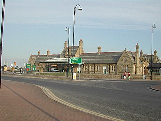
Carnforth is a railway station on the Bentham and Furness Lines, 6 miles (10 km) north of Lancaster, England, which serves the market town of Carnforth, Lancashire. It is owned by Network Rail and managed by Northern Trains.
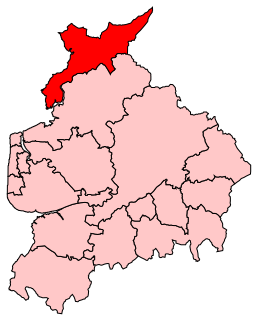
Morecambe and Lunesdale is a constituency represented in the House of Commons of the UK Parliament since 2010 by David Morris, a Conservative.

Morecambe is a railway station on the Morecambe Branch Line, which runs between Lancaster and Heysham Port. The station, situated 4 miles (6 km) west of Lancaster, serves the town of Morecambe in Lancashire. It is owned by Network Rail and managed by Northern Trains.
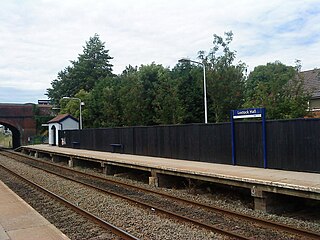
Lostock Hall railway station is 2+3⁄4 miles (4.4 km) south of Preston station, England. It is on the East Lancashire Line and is managed by Northern, who also provide all passenger trains serving it.

Slyne-with-Hest is a civil parish in the City of Lancaster in Lancashire, England. It had a population of 3,163 recorded in the 2001 census, decreasing to 3,126 at the 2011 Census. The parish is north of Lancaster and consists of two villages; Slyne, on the A6 road, and Hest Bank on the coast.
Weaver Junction is a railway junction connecting the West Coast Main Line (WCML) with the Weaver Junction–Liverpool line, opening on 1 April 1869. Trains bound for Liverpool from London diverge from the WCML at this junction. Weaver Junction is the oldest flying junction in Britain.

Hest Bank North Junction is a railway junction in Lancashire, England, where the Morecambe Branch Line joins the former London and North Western Railway (LNWR) line in the down direction between Lancaster and Carnforth. It is also known as Morecambe North Junction. This line is currently being considered to become a community railway. Hest Bank railway station was situated here until its closure on 3 February 1969. Little trace of the old station remains, the platforms having been demolished prior to the electrification of the line in 1973. It is also the only location on the entire 401 mile (643 km) WCML where the coastline and Irish Sea is visible from the railway.
Keckwick is an area in the Borough of Halton in Cheshire. Although there is no village as such, numerous toponyms attest to a particular identity in the area which straddles the West Coast Main Line between the village of Daresbury and the new town of Runcorn.

Bare Lane is a railway station on the Morecambe Branch Line, which runs between Lancaster and Heysham Port. The station, situated 2+1⁄2 miles (4 km) west of Lancaster, serves the suburb of Bare in Morecambe, Lancashire. It is owned by Network Rail and managed by Northern Trains.

Willesden railway station was a station about 50 yards (46 m) north of Acton Lane level crossing in Harlesden, Middlesex, opened in 1841 by the London and Birmingham Railway (L&BR) on what became the West Coast Main Line (WCML). It had wooden platforms about 50 yards (46 m) long beside each of the two tracks, a small wooden ticket office with an awning and a coal siding. It was about 3⁄4 mile (1.2 km) south of the original village of Willesden, in what is now the London Borough of Brent. It closed later the same year, reopened in 1844 and closed finally when the L&BR's successor, the London and North Western Railway (LNWR), opened Willesden Junction station about 1⁄2 mile (0.8 km) to the southeast on 1 September 1866. On 15 June 1912 the LNWR opened a new station, known as Harlesden, near the site.
Morecambe Promenade Station was a railway station in Morecambe, Lancashire, England. It was opened on 24 March 1907 by the Midland Railway and closed in February 1994. After twelve weeks break in passenger service for the revision of track work and signalling a new Morecambe station was opened on a site closer to the town centre.

The Leeds–Morecambe line, also known as the Bentham line, is a railway line running between Leeds, Skipton, Lancaster and Morecambe in northern England. The service is operated by Northern. The route covered by the service was historically part of the Midland Railway. The line is electrified at 25 kV AC overhead between Leeds City and Skipton- this section is known as the Airedale line.

Hest Bank railway station was opened by the Lancaster and Carlisle Railway (L&CR) three miles north of Lancaster Castle railway station. The line had been authorised in 1844 and a station was proposed for the village of Hest Bank, Lancashire, the following year. It opened in 1846 along with the line. The station continued to serve the village of Hest Bank until its closure in 1969. The site remains notable as being the point at which the present-day West Coast Main Line (WCML) comes nearest to the west coast. Views of Morecambe Bay can be glimpsed from trains on this section of the line.

Morecambe Euston Road was the terminus station of the London and North Western Railway's branch line to Morecambe, in Lancashire, England. It closed in 1962, after which all trains to Morecambe used the nearby Morecambe Promenade station.

National Cycle Network (NCN) Route 69 is a Sustrans National Route that runs from Hest Bank to Cleethorpes. The route is incomplete and consists of one long section in Lancashire, and seven short sections in West Yorkshire. The open sections are signed in both directions.

The A724 road in Scotland runs within South Lanarkshire between Rutherglen and Hamilton. It follows an ancient route which is marked on William Roy's Lowland Map of Scotland (1755) with only minor deviations from its modern course.
