
Gloucestershire is a county in South West England. The county comprises part of the Cotswold Hills, part of the flat fertile valley of the River Severn, and the entire Forest of Dean.

Peckham is a district of south London, England, within the London Borough of Southwark. It is 3.5 miles (5.6 km) south-east of Charing Cross. At the 2001 Census the Peckham ward had a population of 14,720.
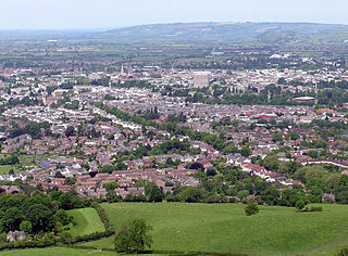
Cheltenham is a large spa town and borough on the edge of the Cotswolds in the county of Gloucestershire, England. Cheltenham became known as a health and holiday spa town resort following the discovery of mineral springs in 1716.

Nitshill is a district on the south side of Glasgow. It is bordered by South Nitshill to the south, Darnley to the east, Crookston and Roughmussel to the north-west, Hurlet to the west and Househillwood and Priesthill to the north, with the Pollok district and the Silverburn Centre beyond. An area of open ground to the south-west of Nitshill forms the boundary between Glasgow and the town of Barrhead in East Renfrewshire.

Ballymun is an outer suburb of Dublin, Ireland, at the northern edge of the Northside, the development of which began in the 1960s to accommodate a housing crisis in inner city areas of Dublin. The area became well known for its high-rise tower blocks and flat complexes. It has several sub-districts such as Sillogue and Poppintree, and is in close proximity to Dublin Airport.

Canning Town is a district in East London, England. It has formed part of the London Borough of Newham since 1965. It is located in the area of the former Royal Docks on the north side of the River Thames, and is the location of Rathbone Market. Canning Town was part of the ancient parish of West Ham in the county of Essex. It was transferred to Greater London in 1965.

Seacroft is an outer-city suburb/township consisting mainly of council estate housing covering an extensive area of east Leeds, West Yorkshire, England. It lies in the LS14 Leeds postcode area, around 4 miles (6.4 km) east of Leeds city centre.
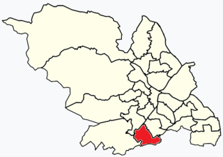
Beauchief and Greenhill ward—which includes the districts of Batemoor, Beauchief, Chancet Wood, Greenhill, Jordanthorpe, and Lowedges—is one of the 28 electoral wards in City of Sheffield, England. It is located in the southern part of the city and covers an area of 2.4 square miles (6.2 km2). The population of this ward in 2016 was estimated to be 19,669 people in 9,209 houses.

Cheltenham is a constituency represented in the House of Commons of the UK Parliament. As with all constituencies, the constituency elects one Member of Parliament (MP) by the first past the post system of election at least every five years.

The Aylesbury Estate is a large housing estate located in Walworth, South East London.

Barlanark is a district in the Scottish city of Glasgow. It is situated east of Budhill, Shettleston and Springboig, north west of Baillieston, west of Springhill and Swinton and south of Easthall, Easterhouse and Wellhouse.

Roundshaw is a housing estate and park in south Wallington and Beddington on the eastern edge of the London Borough of Sutton. Grid Ref TQ302633.
Benhall is a small district within the town of Cheltenham, Gloucestershire. It lies south-west of the town centre, just south of the A40, the main road to Gloucester, and north of the district of Up Hatherley. It falls mainly within the Anglican parish of St Mark.
Rowanfield is a neighbourhood in Cheltenham, England. It consists primarily of a social housing estate of Wimpey no-fines houses and low-rise flats, built around 1953, with Rowanfield School and a playing field to the West separating it from Hesters Way and also the older Rowanfield Road to the East. To the south-west Rowanfield borders the district of St Mark's. Rowanfield is located 1.5 miles west of the centre of Cheltenham.
Halton Moor is a district of east Leeds, West Yorkshire, England, about three miles east of Leeds city centre close to the A63. It is situated between Killingbeck to the north, Temple Newsam to the south, Osmondthorpe to the west and Halton and Colton to the east.

The Ferrier Estate was a large housing estate located in Kidbrooke, Greenwich, south London. Built as social housing between 1968 and 1972, it was demolished as part of the Kidbrooke Vision scheme between 2009 and 2012 and replaced with housing and retail space known as Kidbrooke Village.

Seacroft pre-dates the Domesday book, with evidence of a settlement in the area from the Neolithic Age. Seacroft remained largely unchanged for centuries as a small Yorkshire village, until in the 1950s the area was developed into Leeds' largest council estate. In the 1960s and 1970s the building of Whinmoor and Swarcliffe enclosed Seacroft within other suburbs.

"The Doughnut" is the nickname given to the headquarters of the Government Communications Headquarters (GCHQ), a British cryptography and intelligence agency. It is located on a 71-hectare (176-acre) site in Benhall, in the suburbs of Cheltenham, Gloucestershire, in South West England. The Doughnut houses 5,500 employees; GCHQ is the largest single employer in Gloucestershire. Built to modernise and consolidate GCHQ's multiple buildings in Cheltenham, The Doughnut was completed in 2003, and GCHQ moved into the building in 2004. It is the largest building constructed for secret intelligence operations outside the United States. The Doughnut was too small for the number of staff at its completion, and a second building in a secret and undisclosed location in the 'Gloucestershire area' now also accommodates staff from GCHQ. The Doughnut is surrounded by car and bicycle parking in concentric rings, and well protected by security.

Public housing provided the majority of rented accommodation in the United Kingdom until 2011 when the number of households in private rental housing surpassed the number in social housing. Houses and flats built for public or social housing use are built by or for local authorities and known as council houses, though since the 1980s the role of non-profit housing associations became more important and subsequently the term "social housing" became more widely used, as technically council housing only refers to housing owned by a local authority, though the terms are largely used interchangeably. Before 1865, housing for the poor was provided solely by the private sector. Council houses were built on council estates, where other amenities, like schools and shops, were often also provided. From the 1950s, blocks of flats and three- or four-storey blocks of maisonettes were widely built, alongside large developments of terraced housing, while the 1960s and the 1970s saw construction of many high-rise tower blocks. Flats and houses were also built in mixed estates.

The Granby Four Streets is an area in Toxteth, Liverpool, England, comprising four streets at the tip of a triangle near the Grade II* listed Princes Park. The streets, designed by Welsh architect Richard Owens and built by Welsh workers during the late 19th century are Beaconsfield Street, Cairns Street, Jermyn Street and Ducie Street. A fifth street, Granby Street, connects the four streets together and mostly contains commercial units.
