
Sedimentary rocks are types of rock that are formed by the accumulation or deposition of mineral or organic particles at Earth's surface, followed by cementation. Sedimentation is the collective name for processes that cause these particles to settle in place. The particles that form a sedimentary rock are called sediment, and may be composed of geological detritus (minerals) or biological detritus. The geological detritus originated from weathering and erosion of existing rocks, or from the solidification of molten lava blobs erupted by volcanoes. The geological detritus is transported to the place of deposition by water, wind, ice or mass movement, which are called agents of denudation. Biological detritus was formed by bodies and parts of dead aquatic organisms, as well as their fecal mass, suspended in water and slowly piling up on the floor of water bodies. Sedimentation may also occur as dissolved minerals precipitate from water solution.

Mudflats or mud flats, also known as tidal flats or, in Ireland, slob or slobs, are coastal wetlands that form in intertidal areas where sediments have been deposited by tides or rivers. A global analysis published in 2019 suggested that tidal flat ecosystems are as extensive globally as mangroves, covering at least 127,921 km2 (49,391 sq mi) of the Earth's surface. They are found in sheltered areas such as bays, bayous, lagoons, and estuaries; they are also seen in freshwater lakes and salty lakes alike, wherein many rivers and creeks end. Mudflats may be viewed geologically as exposed layers of bay mud, resulting from deposition of estuarine silts, clays and aquatic animal detritus. Most of the sediment within a mudflat is within the intertidal zone, and thus the flat is submerged and exposed approximately twice daily.

The exposed geology of the Capitol Reef area presents a record of mostly Mesozoic-aged sedimentation in an area of North America in and around Capitol Reef National Park, on the Colorado Plateau in southeastern Utah.
A way up structure, way up criterion, or geopetal indicator is a characteristic relationship observed in a sedimentary or volcanic rock, or sequence of rocks, that makes it possible to determine whether they are the right way up or have been overturned by subsequent deformation. This technique is particularly important in areas affected by thrusting and where there is a lack of other indications of the relative ages of beds within the sequence, such as in the Precambrian where fossils are rare.

In geology, cross-bedding, also known as cross-stratification, is layering within a stratum and at an angle to the main bedding plane. The sedimentary structures which result are roughly horizontal units composed of inclined layers. The original depositional layering is tilted, such tilting not being the result of post-depositional deformation. Cross-beds or "sets" are the groups of inclined layers, which are known as cross-strata.

In geology, a lens or lentil is a body of ore or rock that is thick in the middle and thin at the edges, resembling a convex lens in cross-section.

In geology, depositional environment or sedimentary environment describes the combination of physical, chemical, and biological processes associated with the deposition of a particular type of sediment and, therefore, the rock types that will be formed after lithification, if the sediment is preserved in the rock record. In most cases, the environments associated with particular rock types or associations of rock types can be matched to existing analogues. However, the further back in geological time sediments were deposited, the more likely that direct modern analogues are not available.

Sedimentary structures include all kinds of features in sediments and sedimentary rocks, formed at the time of deposition.

Flaser beds are a sedimentary, bi-directional, bedding pattern created when a sediment is exposed to intermittent flows, leading to alternating sand and mud layers. While flaser beds typically form in tidal environments, they can (rarely) form in fluvial conditions - on point bars or in ephemeral streams, or also in deep water environments when turbiditic sediments are reworked by seasonal bottom-currents. Individual sand ripples are created, which are later infilled by mud during quieter flow periods. These mud drapes are typically a minor constituent of the deposit; they can consolidate within three hours, protecting the underlying layer from erosion. Flaser bedding typically forms in high-energy environments.
Hummocky cross-stratification is a type of sedimentary structure found in sandstones. It is a form of cross-bedding usually formed by the action of large storms, such as hurricanes. It takes the form of a series of "smile"-like shapes, crosscutting each other. It is only formed at a depth of water below fair-weather wave base and above storm-weather wave base. They are not related to "hummocks" except in shape.

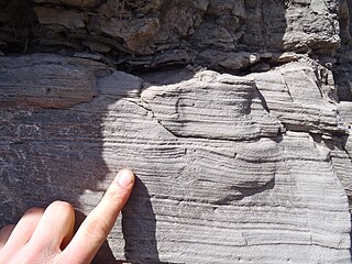
Lenticular bedding is a sedimentary bedding pattern displaying alternating layers of mud and sand. Formed during periods of slack water, mud suspended in the water is deposited on top of small formations of sand once the water's velocity has reached zero. Lenticular bedding is classified by its large quantities of mud relative to sand, whereas a flaser bed consists mostly of sand. The sand formations within the bedding display a 'lens-like' shape, giving the pattern its respected name. They are commonly found in high-energy environments such as the intertidal and supratidal zones. Geologists use lenticular bedding to show evidence of tidal rhythm, tidal currents and tidal slack, in a particular environment.
The Triassic Lockatong Formation is a mapped bedrock unit in Pennsylvania, New Jersey, and New York. It is named after the Lockatong Creek in Hunterdon County, New Jersey.
Vegetation-induced sedimentary structures (VISS) are primary sedimentary structures formed by the interaction of detrital sediment with in situ plants. VISS provide physical evidence of vegetation's fundamental role in mediating sediment accumulation and erosion in clastic depositional environments. VISS can be broken into seven types, five being hydrodynamic and two being decay-related. The simple hydrodynamic VISS are categorized by centroclinal cross strata, scratch semicircles and upturned beds. The complex hydrodynamic VISS are categorized by coalesced scour fills and scour-and-mound beds. The decay-related VISS are categorized by mudstone-filled hollows and downturned beds.

Soft-sediment deformation structures develop at deposition or shortly after, during the first stages of the sediment's consolidation. This is because the sediments need to be "liquid-like" or unsolidified for the deformation to occur. These formations have also been put into a category called water-escape structures by Lowe (1975). The most common places for soft-sediment deformations to materialize are in deep water basins with turbidity currents, rivers, deltas, and shallow-marine areas with storm impacted conditions. This is because these environments have high deposition rates, which allows the sediments to pack loosely.
Iron-rich sedimentary rocks are sedimentary rocks which contain 15 wt.% or more iron. However, most sedimentary rocks contain iron in varying degrees. The majority of these rocks were deposited during specific geologic time periods: The Precambrian, the early Paleozoic, and the middle to late Mesozoic. Overall, they make up a very small portion of the total sedimentary record.

The Bass Formation, also known as the Bass Limestone, is a Mesoproterozoic rock formation that outcrops in the eastern Grand Canyon, Coconino County, Arizona. The Bass Formation erodes as either cliffs or stair-stepped cliffs. In the case of the stair-stepped topography, resistant dolomite layers form risers and argillite layers form steep treads. In general, the Bass Formation in the Grand Canyon region and associated strata of the Unkar Group-rocks dip northeast (10°–30°) toward normal faults that dip 60+° toward the southwest. This can be seen at the Palisades fault in the eastern part of the main Unkar Group outcrop area. In addition, thick, prominent, and dark-colored basaltic sills intrude across the Bass Formation.

The Dox Formation, also known as the Dox Sandstone, is a Mesoproterozoic rock formation that outcrops in the eastern Grand Canyon, Coconino County, Arizona. The strata of the Dox Formation, except for some more resistant sandstone beds, are relatively susceptible to erosion and weathering. The lower member of the Dox Formation consists of silty-sandstone and sandstone, and some interbedded argillaceous beds, that form stair-stepped, cliff-slope topography. The bulk of the Dox Formation typically forms rounded and sloping hill topography that occupies an unusually broad section of the canyon.

The Bright Angel Shale is one of five geological formations that comprise the Cambrian Tonto Group. It and the other formations of the Tonto Group outcrop in the Grand Canyon, Arizona, and parts of northern Arizona, central Arizona, southeast California, southern Nevada, and southeast Utah. The Bright Angel Shale consists of locally fossiliferous, green and red-brown, micaceous, fissile shale (mudstone) and siltstone with local, thicker beds of brown to tan sandstone and limestone. It ranges in thickness from 57 to 450 feet. Typically, its thin-bedded shales and sandstones are interbedded in cm-scale cycles. They also exhibit abundant sedimentary structures that include current, oscillation, and interference ripples. The Bright Angel Shale also gradually grades downward into the underlying Tapeats Sandstone. It also complexly interfingers with the overlying Muav Limestone. These characters make the upper and lower contacts of the Bright Angel Shale often difficult to define. Typically, its thin-bedded shales and sandstones erode into green and red-brown slopes that rise from the Tonto Platform up to cliffs formed by limestones of the overlying Muav Limestone and dolomites of the Frenchman Mountain Dolostone.

The Gai-As Formation is an Early to Middle Permian geologic formation correlated with the Ecca Group and designated "Ecca" Group, because it does not belong to the Karoo, in the southwestern Kunene Region and northern Erongo Region of northwestern Namibia. The Gai-As Formation represents the second-oldest sedimentary unit of the Huab Basin, overlying the Huab Formation. The formation was deposited in a fluvial to lacustrine setting.
The Alajuela Formation, originally Alhajuela Formation (Tau), is a Late Miocene geologic formation in the Panama Canal Zone of central Panama.

