Tamatea / Dusky Sound is a fiord on the southwest corner of New Zealand, in Fiordland National Park.

Jervis Inlet is one of the principal inlets of the British Columbia Coast, about 95 km (59 mi) northwest of Vancouver, and the third of such inlets north of the 49th parallel, the first of which is Burrard Inlet, Vancouver's harbour.
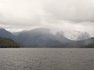
Toba Inlet is one of the lesser, but still principal, inlets of the British Columbia Coast. It is fourth in the series north from the 49th parallel which begins with Burrard Inlet, which is the harbour for the city of Vancouver. Between it and Jervis Inlet to its east, however, there is a freshwater fjord, Powell Lake, which has been augmented by a small hydro project to supply power to the large pulp mill at Powell River, the principal town of the Malaspina Peninsula of the upper Sunshine Coast. Klahoose 1 Reserve, of the Klahoose First Nation is at the mouth of Toba River at the Head of Toba Inlet. Toba Inlet and the Toba Valley is home to many grizzly bears.
Seymour Inlet is one of the lesser travelled of the principal inlets of the British Columbia Coast. Unlike larger inlets such as Knight or Bute, it is not flanked by mountains but by relatively low, but still rugged, coastal hill-country and forms a maze of complex, narrow waterways and tidal pools and lagoons. It is located within a corresponding maze of peninsulas on the mainland on the northwest side of the Queen Charlotte Strait region.

Khutzeymateen Inlet is one of the lesser principal inlets of the British Columbia Coast. It is important in being part of the first area in Canada protected to preserve grizzly bears and their habitat via the Khutzeymateen/K’tzim-a-deen Grizzly Sanctuary. The inlet and the park-sanctuary surrounding it are between the mouths of the Skeena and Nass Rivers; the Khutzeymateen is the next inlet north from Work Channel, which is the north side of the Tsimpsean Peninsula of "Greater Prince Rupert". The inlet's mouth opens onto an arm of Portland Inlet, Steamer Passage, which lies next to Sommerville Island. The entrance to Khutzeymateen Inlet is between Keemein Point and Welgeegenk Point. The closest community is Lax Kw'alaams, formerly Port Simpson.

Princess Royal Island is the largest island on the North Coast of British Columbia, Canada. It is located amongst the isolated inlets and islands east of Hecate Strait on the British Columbia Coast. At 2,251 square kilometres (869 sq mi), it is the fourth largest island in British Columbia. It was named in 1788 by Captain Charles Duncan, after his ship Princess Royal.
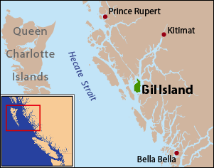
Gil Island is an island on the North Coast of British Columbia, Canada, located on the west side of Whale Channel in the entrance to Douglas Channel, one of the main coastal inlets, on the route of the Inside Passage between Pitt Island and Princess Royal Island. It is 26 km (16 mi) long, with a width ranging from 6 to 13 km, and an area of 231 km2. The only named summit on the mountainous island is Mount Gil, which faces the opening of Douglas Channel.

Indian Arm is a steep-sided glacial fjord adjacent to the city of Vancouver in southwestern British Columbia. Formed during the last Ice Age, it extends due north from Burrard Inlet, between the communities of Belcarra and the District of North Vancouver, then on into mountainous wilderness. Burrard Inlet and the opening of Indian Arm was mapped by Captain George Vancouver and fully explored days later by Dionisio Alcalá Galiano in June 1792.

The Gwa'Sala-Nakwaxda'xw Nations are a union of two Kwakwaka'wakw peoples in a band government based on northern Vancouver Island in British Columbia, Canada, whose main reserve community is near the town of Port Hardy in the Queen Charlotte Strait region of the Central Coast region of British Columbia, Canada. The band government is a member of the Kwakiutl District Council and, for treaty negotiation purposes, the Winalagalis Treaty Group which includes three other members of the Kwakiutl District Council.

Porcher Island is an island in Hecate Strait, British Columbia, Canada, near the mouth of the Skeena River and southwest of the port city of Prince Rupert. The locality of Porcher Island is located near the island's northern tip at Humpback Bay, 54°05′11″N130°23′23″W. Stephens and Prescott Islands are located off its northwestern tip.

Wales Island is an island on the North Coast of British Columbia, Canada, situated east of the Dixon Entrance at the entrance to Portland Inlet.
The ƛoʔos Klahoose are one of the three groups comprising the ʔayʔaǰuθəm Tla'Amin or Mainland Comox. The other two divisions of this once-populous group are the χʷɛmaɬku Homalco and Sliammon. The Klahoose, Homalco and Sliammon are, according to oral tradition, the descendants of the survivors of the Great Flood. The three groups were split by colonialism into different band councils but united historically as the Tla A'min, known as the Mainland Comox, and K’ómoks, the larger grouping of the Comox people, also known as the Island Comox and before the merger with the Laich-kwil-tach culture. Historically both groups are a subgroup of the Coast Salish though the K’ómoks name is from, and their language today, is the Lik'wala dialect of Kwak'wala. The ancestral tongue is the Comox language, though the Sahtloot/Island dialect is extinct.
Smith Sound is a sound on the Central Coast of British Columbia, Canada, located to the south of Rivers Inlet and between the Queen Charlotte Strait region (S) and Fitz Hugh Sound (N).
Observatory Inlet is an inlet on the North Coast of British Columbia. It is a northward extension of Portland Inlet, other branches of which include the Portland Canal. The entrance of Observatory Inlet, from Portland Inlet, lies between Ramsden Point and Nass Point. Ramsden Point also marks, to the west, the entrance of Portland Canal. Observatory Inlet was named by George Vancouver in 1793, because he set up his observatory on the shore of the inlet, at Salmon Cove, in order to calibrate his chronometers. His two vessels, HMS Discovery and HMS Chatham, stayed in Salmon Cove from July 23 to August 17, 1793. During this time a boat surveying expedition under Vancouver himself explored Behm Canal. Vancouver also named three headlands at the entrance of Observatory Inlet: Maskelyne Point, for Nevil Maskelyne, the Astronomer Royal, Wales Point, for William Wales, the mathematical master who sailed with James Cook, and Ramsden Point, after the famed mathematical instrument-maker Jesse Ramsden.
Kumealon Inlet is an inlet on the Coast of British Columbia, Canada. It lies on the eastern side of the north end of Grenville Channel facing Pitt Island.
Drury inlet is an inlet in the Queen Charlotte Strait region of the Central Coast of British Columbia, Canada, extending west from Wells Passage to the northwest of North Broughton Island, northwest of the town of Port Hardy. Branching off to the northeast from the north side of the head of the inlet is Actaeon Sound.

Nepean Bay is a bay located on the north-east coast of Kangaroo Island in the Australian state of South Australia about 130 kilometres south-south-west of Adelaide. It was named by the British navigator, Matthew Flinders, after Sir Evan Nepean on 21 March 1802.

Seaforth Channel is a channel in the Central Coast region of the Canadian province of British Columbia which is part of the Inside Passage - the 950 miles (1,530 km) passage between Seattle, Washington and Juneau, Alaska. The marine highway goes through Seaforth Channel on the way to Milbanke Sound, one of the open sea portions of the Inland Passage. Seaforth Channel which is part of the Prince Rupert/Port Hardy BC ferry route, extends in a westerly direction from Denny Island to Milbanke Sound between Denny Island, Campbell Island and the Wright group of islands on the south. In October 2016, a Texas-owned tug/barge transiting the Canadian waters of the Inside Passage without a local pilot was hard grounded on a reef at the entrance to Seaforth Channel in October 2016. More than 100,000 L of fuel contaminated the coast, coves and shores 20 km (12 mi) west of Bella Bella, the core community of the Heiltsuk Nation as well as the environmentally sensitive Great Bear Rainforest - Canada's contribution to the Queen's Commonwealth Canopy (QCC), a network of forest conservation programs. Clean up response and salvage was criticized by the Heiltsuk, B.C. Premier Christy Clark and Prime Minister Justin Trudeau. In November in Vancouver the Prime Minister announced a $1.5B ocean protection plan to "create a marine safety system, restore marine ecosystems and undertake research into oil spill cleanup methods."

Checleset Bay is a bay on the northwest coast of Vancouver Island, British Columbia, Canada. It is located southeast of Brooks Peninsula and northwest of Kyuquot Sound. Much of the land around the bay is part of Brooks Peninsula Provincial Park. Checleset Bay has three large inlets, Nasparti Inlet, Ououkinsh Inlet, and Malksope Inlet.