Related Research Articles

The smallmouth bass is a species of freshwater fish in the sunfish family (Centrarchidae) of the order Perciformes. It is the type species of its genus Micropterus, and is a popular game fish sought by anglers throughout the temperate zones of North America, and has been spread by stocking—as well as illegal introductions—to many cool-water tributaries and lakes in Canada and more so introduced in the United States. The maximum recorded size is approximately 27 inches and 12 pounds. The smallmouth bass is native to the upper and middle Mississippi River basin, the Saint Lawrence River–Great Lakes system, and up into the Hudson Bay basin. The world record size was 11 lbs and 15 ounces caught in the reservoir Dale Hollow, on the Kentucky—Tennessee border. Its common names include smallmouth, bronzeback, brown bass, brownie, smallie, bronze bass, and bareback bass.

Lake Sammamish is a freshwater lake 8 miles (13 km) east of Seattle in King County, Washington, United States. The lake is 7 miles (11 km) long and 1.5 miles (2 km) wide, with a maximum depth of 105 feet (32 m) and a surface area of 8 sq mi (21 km2). It lies east of Lake Washington and west of the Sammamish Plateau, and stretches from Issaquah in the south to Redmond in the north. At Issaquah it is fed by Issaquah Creek, and at Redmond it drains to Lake Washington via the Sammamish River, named after the native people who once lived along its entire length.
The Rahway River is a river in Essex, Middlesex, and Union Counties, New Jersey, United States, The Rahway, along with the Elizabeth River, Piles Creek, Passaic River, Morses Creek, the Fresh Kills River, has its river mouth at the Arthur Kill.

The River Raisin is a river in southeastern Michigan, United States, that flows through glacial sediments into Lake Erie. The area today is an agricultural and industrial center of Michigan. The river flows for almost 139 miles (224 km), draining an area of 1,072 square miles (2,780 km2) in the Michigan counties of Lenawee, Washtenaw, Jackson, Hillsdale, and Monroe County, where its mouth at Lake Erie is located. French settlers named it as La Rivière aux Raisins because of the wild grapes growing along its banks, the French word for grape being raisin. The French term for "raisin" is raisin sec.

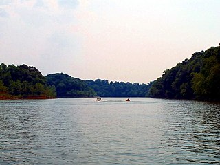
The Dale Hollow Reservoir is a reservoir situated on the Kentucky/Tennessee border. The lake is formed by the damming of the Obey River, 7.3 miles (12 km) above its juncture with the Cumberland River at river mile 380. Portions of the lake also cover the Wolf River. Dale Hollow is one of four major flood control reservoirs for the Cumberland; the others being Percy Priest Lake, Lake Cumberland, and Center Hill Lake. It is also the site of Dale Hollow Lake State Park on the north (Kentucky) side.

Elkhorn Creek is an 18.3-mile-long (29.5 km) stream running through several counties in central Kentucky in the United States. The stream drains an area of 499.5 square miles (1,294 km2). It derives its name from the shape, as seen on a map, of its main stem with its two primary forks.

Cave Run Lake, located south of Morehead, Kentucky, USA along Kentucky Route 801, is an 8,270-acre (33 km2) reservoir built by the U.S. Army Corps of Engineers. The 148 ft (45 m), half-mile dam construction began in 1965 and was completed in 1973. Cave Run Lake is in the northern part of the Daniel Boone National Forest. Cave Run Lake provides flood protection to the lower Licking River valley, supplies water to the area's communities, improves the Licking River's water flow conditions, and offers a habitat for various species of fish and wildlife. It is in Rowan, Morgan, Menifee, and Bath counties.

The Spring River is a 129-mile-long (208 km) waterway located in southwestern Missouri, southeastern Kansas, and northeastern Oklahoma.

Clinton Lake is a reservoir on the southwestern edge of Lawrence, Kansas. The lake was created by the construction of the Clinton Dam, and the 35 square miles (91 km²) of land and water is maintained by the U.S. Army Corps of Engineers.

Daylighting can be defined as "opening up buried watercourses and restoring them to more natural conditions". An alternative definition refers to "the practice of removing streams from buried conditions and exposing them to the Earth's surface in order to directly or indirectly enhance the ecological, economic and/or socio-cultural well-being of a region and its inhabitants”. The term is used to refer to the restoration of an originally open-air watercourse, which had at some point been diverted below ground, back into an above-ground channel. Typically, the rationale behind returning the riparian environment of a stream, wash, or river to a more natural state is to reduce runoff, create habitat for species in need of it, or improve an area's aesthetics. In the UK, the practice is also known as deculverting.
The California Natural Resources Agency (CNRA) is a state cabinet-level agency in the government of California. The institution and jurisdiction of the Natural Resources Agency is provided for in California Government Code sections 12800 and 12805, et seq. The Agency has six departments, 10 conservancies, 17 boards and commissions, three councils, and one urban park in Los Angeles that consists of two museums, the California Science Center and the California African American museum. Through its 25 departments, conservancies and commissions, the Natural Resources Agency is responsible for protecting prehistory history, natural landscapes and cultural sites, monitoring and stewarding state lands and waterways, and regulating fish and game use, as well as private lands and the intersection with federal lands and waters.
Jim Newberry was mayor of Lexington, Kentucky from December 31, 2006, until January 2, 2011. He defeated incumbent mayor Teresa Isaac by the largest vote margin in the history of Lexington-Fayette's merged "Urban County" government. This was also the first time in Lexington-Fayette history that a challenger had defeated a sitting mayor.

Barren River Lake State Resort Park is a 1,053-acre (426 ha) park located in Barren County, Kentucky and extending into parts of Allen County and Monroe County. Barren River Lake, its major feature, is an artificial lake created with the building of a 146-foot-high (45 m) dam by the U.S. Army Corps of Engineers begun in 1960. It covers approximately 10,000 acres (4,000 ha) and has 141 miles (227 km) of shoreline. The park was dedicated in 1965.
The Rough River Lake is a Y-shaped reservoir located in Breckinridge, Hardin, and Grayson counties in Kentucky, about 70 miles southwest of Louisville. This lake was created by the building of a dam, begun in 1955 and completed in 1961, 89.3 miles above the connection between the Rough River and the Green River. The land and water, along with the wildlife, fisheries, and recreational activities, are all managed under the cooperation of the U.S. Army Corps of Engineers and the Commonwealth of Kentucky. A primary attraction is Rough River Dam State Resort Park.

The Little River is a tributary of the Red River, with a total length of 217 miles (349 km), 130 miles (210 km) within the Choctaw Indian Reservation in southeastern Oklahoma and 87 miles (140 km) in southwestern Arkansas in the United States. Via the Red, it is part of the watershed of the Mississippi River. Six large reservoirs impound the Little River and its tributaries. The drainage basin of the river totals 4,204 square miles (10,890 km2), 2,204 square miles (5,710 km2) in Oklahoma and 2,036 square miles (5,270 km2) in Arkansas. The Little River and its upper tributaries are popular for recreational canoeing and kayaking.
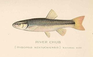
The hornyhead chub is a small species of minnow in the family Cyprinidae of order Cypriniformes. It mainly inhabits small rivers and streams of the northern central USA, up into Canada. The adults inhabit faster, rocky pools of rivers.

Willard Bay is a man-made fresh water reservoir in the Great Salt Lake, in northern Utah. The bay was separated from the Great Salt Lake in 1964, and has since served as a source of irrigation water and recreation for the northern Wasatch Front metro area.

Urban runoff is surface runoff of rainwater, landscape irrigation, and car washing created by urbanization. Impervious surfaces are constructed during land development. During rain, storms and other precipitation events, these surfaces, along with rooftops, carry polluted stormwater to storm drains, instead of allowing the water to percolate through soil. This causes lowering of the water table and flooding since the amount of water that remains on the surface is greater. Most municipal storm sewer systems discharge stormwater, untreated, to streams, rivers and bays. This excess water can also make its way into people's properties through basement backups and seepage through building wall and floors.

The Philadelphia Water Department is the public water utility for the City of Philadelphia. PWD provides integrated potable water, wastewater, and stormwater services for Philadelphia and some communities in Bucks, Delaware and Montgomery counties. PWD is a municipal agency of the City of Philadelphia, and is seated in rented space at the Jefferson Tower in the Market East area of Center City, Philadelphia.
References
- ↑ U.S. Geological Survey Geographic Names Information System: Hickman Creek
- ↑ Jeff Ross. "Stream Smallmouth: The Best Kentucky Has to Offer" (PDF). Kentucky Department of Fish and Wildlife Resources. Archived from the original (PDF) on July 16, 2011. Retrieved June 15, 2011.
5. “Lexington Creek Sweep.” City of Lexington, https://www.lexingtonky.gov/CreekSweep.
6.“Stormwater Quality Projects Incentive Grant Program.” City of Lexington, 2021, https://www.lexingtonky.gov/stormwater-incentive-grant-program.
7.“Welcome to the Hickman Creek Conservancy.” Hickman Creek Conservancy, 2019, https://www.hickmancreek.org/.
8.“Water Quality Geocaching Challenge.” City of Lexington, 2021, https://www.lexingtonky.gov/geocaching.
Coordinates: 37°46′05″N84°36′47″W / 37.7681347°N 84.6129975°W
| | This Jessamine County, Kentucky state location article is a stub. You can help Wikipedia by expanding it. |