The London Borough of Hackney is a London borough in Inner London. The historical and administrative heart of Hackney is Mare Street, which lies 5 miles (8 km) north-east of Charing Cross. The borough is named after Hackney, its principal district. Southern and eastern parts of the borough are popularly regarded as being part of east London, with the northwest belonging to north London.

The London Borough of Islington is a London borough in Inner London. The borough includes a significant area to the south which forms part of central London. Islington has an estimated population of 215,667. It was formed in 1965 under the London Government Act 1963, which simultaneously abolished the metropolitan boroughs of Islington and Finsbury.
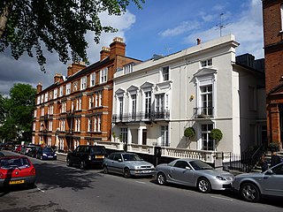
Hampstead is an area in London, England, which lies 4 miles (6.4 km) northwest of Charing Cross, and extends from the A5 road to Hampstead Heath, a large, hilly expanse of parkland. The area forms the northwest part of the London Borough of Camden, a borough in Inner London which for the purposes of the London Plan is designated as part of 'Central London'.

Highgate is a suburban area of north London at the northeastern corner of Hampstead Heath, 4.5 miles (7.2 km) north-northwest of Charing Cross.

Hornsey is a district of north London, England in the London Borough of Haringey. It is an inner-suburban, for the most part residential, area centred 10 km (6.2 mi) north of Charing Cross. It adjoins green spaces Queen's Wood and Alexandra Park to the north.

Muswell Hill is a suburban district of north London. It is mainly in the London Borough of Haringey with a small part in the London Borough of Barnet. It is between Highgate, Hampstead Garden Suburb, East Finchley and Crouch End. It has many streets with Edwardian architecture.

The London Borough of Haringey is a London borough in North London, classified by some definitions as part of Inner London, and by others as part of Outer London. It was created in 1965 by the amalgamation of three former boroughs. It shares borders with six other London boroughs. Clockwise from the north, they are: Enfield, Waltham Forest, Hackney, Islington, Camden, and Barnet.

East Finchley is an area in North London, immediately north of Hampstead Heath. Like neighbouring Muswell Hill it straddles the London Boroughs of Barnet and Haringey, with most of East Finchley falling into the London Borough of Barnet. It has the greenest high road in London

Gospel Oak is an inner urban area of north west London in the London Borough of Camden at the very south of Hampstead Heath. The neighbourhood is positioned between Hampstead to the north-west, Dartmouth Park to the north-east, Kentish Town to the south-east, and Belsize Park to the south-west. Gospel Oak lies across the NW5 and NW3 postcodes and is served by Gospel Oak station on the London Overground. The North London Suburb, Gospel Oak, has many schools around it.

Crouch End is an area of North London, approximately five miles (8 km) from the City of London in the western half of the borough of Haringey. It is within the Hornsey postal district (N8).
West End most commonly refers to:

Archway is an inner neighbourhood of London, forming part of the London Borough of Islington. It is located 3.8 miles (6 km) north of Charing Cross and is identified as a district centre in the London Plan, surrounded by mixed-density residential development. It straddles the A1 in London and is named after an erstwhile local landmark, the high, single-arched Archway Bridge which crossed the road in a cutting to the north. It has a modern commercial hub around Vantage Point and Archway tube station.

Swiss Cottage is an area of Hampstead in the London Borough of Camden, England. It is centred on the junction of Avenue Road and Finchley Road and includes Swiss Cottage tube station. Swiss Cottage lies 3.25 miles (5.23 km) north-northwest of Charing Cross. The area was named after a public house in the centre of it, known as "Ye Olde Swiss Cottage".

Harringay is a district of north London, England, within the London Borough of Haringey. It is centred on the section of Green Lanes running between the New River, where it crosses Green Lanes by Finsbury Park, and Duckett's Common, near Turnpike Lane.

Stroud Green is a suburb and electoral ward in north London, England, in the London Borough of Haringey. On its south-western side, Stroud Green Road forms part of the boundary with the London Borough of Islington.

Torrens Park is a mainly residential large inner-southern suburb of Adelaide, incorporating some of the foothills and adjacent to the original "Mitcham Village". It was named after Sir Robert Richard Torrens, the instigator of the Torrens title system of land registration and transfer, who built a large home in the area which he named Torrens Park.

Hampstead & Highgate was a parliamentary constituency covering the northern half of the London Borough of Camden which includes the village of Hampstead and part of that of Highgate.
West Green is an area of north London, England, in the United Kingdom and part of the London Borough of Haringey. It is located 5.7 miles (9.22 km) north of Charing Cross.
The London Borough of Camden was created in 1965 from the former area of the metropolitan boroughs of Hampstead, Holborn, and St Pancras, which had formed part of the County of London. The borough was named after Camden Town, which had gained its name from Charles Pratt, 1st Earl Camden in 1795. Since the 17th century, many famous people have lived in its various districts and neighbourhoods.
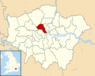
The London Borough of Camden is a borough in Inner London and, for the purposes of the London Plan has been designated as part of 'Central London'. Camden was historically a part of Middlesex. Camden Town Hall, on Euston Road, lies 1.4 mi (2.3 km) north of Charing Cross. The borough comprises a central area stretching south of Euston Road almost all the way to the Thames at Lincoln's Inn Fields, including parts of the West End of London with its numerous theatres and cultural institutions, and a north-western part north of Euston Road stretching to Hampstead and Highgate.