
Birdwood is a town near Adelaide, South Australia. It is located in the local government areas of the Adelaide Hills Council and the Mid Murray Council.

Alberton is a metropolitan suburb in the west of Adelaide, South Australia, about 20 minutes drive from the city. Part of the City of Port Adelaide Enfield, it is bordered by the suburbs of Rosewater, Queenstown, Cheltenham and Port Adelaide.

Clarendon is a small town in the Adelaide Hills, about 25–30 kilometres (16–19 mi) south of the Adelaide city centre and now regarded as an outer suburb of Adelaide. It lies within the City of Onkaparinga council area. The Clarendon Weir is located in the town area, on the Onkaparinga River.
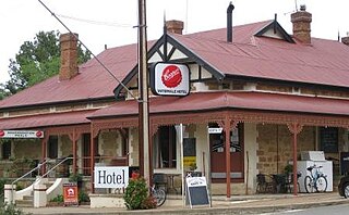
Watervale is a town on the Horrocks Highway in the Clare Valley, South Australia, approximately 9 kilometres north of Auburn and 15 kilometres south of Clare. It is surrounded by a number of small wineries and several B&Bs. The Riesling Trail runs past the town to the west, between the Highway and the Skilly Hills. The town has a number of 19th-century heritage buildings, including the former Stanley Grammar School, which now provides private bed and breakfast accommodation.
St Peters is an inner-eastern suburb of Adelaide, South Australia in the City of Norwood Payneham St Peters.

Stonyfell is an eastern suburb in the foothills of Adelaide, Australia, within the council area of the City of Burnside. It has parks with walking tracks, and two creeks running through it. St Peter's Collegiate Girls' School is the only school in Stonyfell. There is a quarry and a winery, the present-day remnants of industries dating back to the early days of the colonisation of South Australia.
Glenvale is a rural locality in the Toowoomba Region, Queensland, Australia. It is a suburb of Toowoomba. In the 2016 census, Glenvale had a population of 6,353 people.

Lenswood is a semi-rural village situated in the Adelaide Hills east of Adelaide, South Australia. The major industries are apples, pears, cherries and wine grapes.
Eden Hills is a south eastern suburb located in the foothills of Adelaide, South Australia. It is part of the local government area of the City of Mitcham.

Wynnum West is an outer eastern suburb in the City of Brisbane, Queensland, Australia. In the 2016 census, Wynnum West had a population of 12,292 people.
Old Reynella is a metropolitan suburb of Adelaide, South Australia. It is located 20 km south of the Adelaide city centre in the north of the City of Onkaparinga.
Elizabeth Grove is a suburb in the northern extent of Adelaide, South Australia, on the western side of Main North Road south of Elizabeth. It is bounded by Main North Road, Hogarth Road, Harvey Road and Ridley Road. It contains a local shopping centre, public and Catholic primary schools, and churches of several denominations.

Angle Vale is a semi-rural town on the Adelaide Plains between Gawler and Virginia in South Australia. It is steadily being surrounded by Adelaide's suburban sprawl. It is close to many vineyards and farms. The town includes Trinity College's Gawler River campus, and Angle Vale Primary School, but no secondary school. Many students travel to nearby towns or to Gawler.
Flaxley is a small settlement in the Adelaide Hills located 39 km south-east of the centre of the city of Adelaide in South Australia. It is situated in-between the larger towns of Echunga, Macclesfield and Meadows.

Woolshed Flat is a locality near the southern end of the Clare Valley in South Australia. It is located in the District Council of Clare and Gilbert Valleys.
Windsor is a locality in South Australia. It is on the northern Adelaide Plains adjacent to Port Wakefield Road, 34 km southeast of Port Wakefield. The township is largely bypassed by Port Wakefield Road.
Sandergrove is a locality in the Australian state of South Australia about 9 km (5.5 mi) south of Strathalbyn. It was a junction on the Victor Harbor railway line, where the Milang railway line branched off. The railway was authorised in 1881 and closed in 1970.
Poonindie is a small township near Port Lincoln on the Eyre Peninsula, South Australia. The land upon which it sits was originally the land of the Barngarla people.
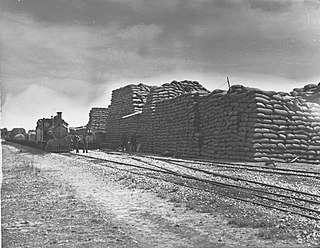
Kybunga is a locality in the Mid North of South Australia. It was on the Gladstone railway line 87+1⁄2 miles (140.8 km) north of Adelaide on the plains to the west of the Clare Valley. Kybunga school opened in 1881 and closed in 1988. The former Methodist and Uniting church opened in 1886 and is now a private residence.

Moonta Mines is a locality at the northern end of the Yorke Peninsula, adjoining the town of Moonta. It is located in the Copper Coast Council. From 1861 to 1923, it was the centre of a copper mining industry that formed colonial South Australia's largest mining enterprise. A substantial portion of the locality is listed on the South Australian Heritage Register as the Moonta Mines State Heritage Area and on the National Heritage List as the Australian Cornish Mining Heritage Site, Moonta Mines.
