Glengowrie is a suburb of the Australian city of Adelaide, approximately 12 kilometres south west of the city centre. The name Glengowrie means "Glen of Gowrie", so called in honour of Lord Gowrie, Governor-General of Australia from 1936 to 1944.
The City of Burnside is a local government area in the South Australian city of Adelaide stretching from the Adelaide Parklands into the Adelaide foothills with an area of 2,753 hectares. It was founded in August 1856 as the District Council of Burnside, the name of a property of an early settler, and was classed as a city in 1943. The LGA is bounded by Adelaide, Adelaide Hills Council, Campbelltown, Mitcham, Norwood Payneham and St Peters and Unley.

Unley is an inner-southern suburb of Adelaide, South Australia, within the City of Unley. The suburb is the home of the Sturt Football Club in the South Australian National Football League (SANFL). Unley neighbours Adelaide Park Lands, Fullarton, Hyde Park, Malvern, Parkside and Wayville.
Mount Osmond is a small suburb of 2,497 people in the South Australian capital city of Adelaide. It is part of the City of Burnside local government area and located in the foothills of the Adelaide Hills, five kilometres south east of the city centre. The suburb is high on the hill of the same name, which is the last hill on the right when approaching Adelaide down the South Eastern Freeway before the road levels out onto the Adelaide Plains. It is bounded to the north by the suburb of Beaumont, to the north-east by Burnside, to the east by Waterfall Gully, to the south by Leawood Gardens/Eagle On The Hill, to the south-west by Urrbrae, to the west by Glen Osmond and to the north-west by St Georges.
Dulwich is a suburb in the City of Burnside, Adelaide, South Australia with a census area population of 2,663 people. The suburb is adjacent to Adelaide's east parklands, and forms part of the western boundary of the City of Burnside. Dulwich is a mix of residential housing and commercial activity–corporate offices and businesses line Fullarton and Greenhill Roads. The suburb is bordered by Rose Park to the north, Toorak Gardens to the east, Glenside to the south and the Adelaide Parklands to the west.

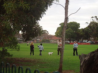
Eastwood is a small triangular inner-southern suburb of Adelaide, South Australia in the City of Burnside.
Frewville is a small suburb in the South Australian city of Adelaide. It is three kilometres south-east of Adelaide's central business district (CBD).

Parkside is an inner southern suburb of Adelaide, South Australia. It is located in the City of Unley.

Black Forest is an inner southern suburb of Adelaide, South Australia. It is located in the City of Unley, bounded by the Glenelg tram line (north-west), the Seaford railway line (south-east), South Road (west) and East Avenue (east).
Highgate is a suburb of Adelaide in the City of Unley. It is surrounded by Fullarton and Malvern.

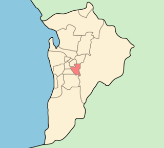
Unley is a single-member electoral district for the South Australian House of Assembly. Named after the suburb of the same name, it is the state's smallest electorate by area at just 14.1 km2 (5.4 sq mi). It is a suburban electorate in Adelaide's inner south, taking in the suburbs of Eastwood, Frewville, Fullarton, Glenside, Glenunga, Goodwood, Highgate, Hyde Park, Kings Park, Malvern, Myrtle Bank, Parkside, Unley, Unley Park and Wayville, as well as parts of Glen Osmond and Millswood.
Fullarton Road is a main road in the South Australian capital city of Adelaide.

Cross Road is a major arterial road that travels east–west through the inner southern suburbs of the Australian city of Adelaide. It is designated route A3.

Glen Osmond Road is a major section of the Princes Highway in the city of Adelaide, South Australia. Connecting the Adelaide city centre with the Adelaide Hills via the South Eastern Freeway; Glen Osmond Road carries half of Adelaide's freight traffic and is the major commuter route from the southern Adelaide Hills. It is designated part of route A1.
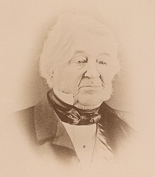
Osmond Gilles was a settler, pastoralist, mine owner and the Colony of South Australia’s first colonial treasurer.

Benacre is a house in Glen Osmond,, which was listed on the now-defunct Register of the National Estate. It is located at 6 Benacre Place.

North Adelaide is a predominantly residential precinct and suburb of the City of Adelaide in South Australia, situated north of the River Torrens and within the Adelaide Park Lands. Laid out in a grid plan in three sections by Colonel William Light in 1837, the suburb contains many grand old mansions.
W. H. Burford and Sons was a soap and candle-making business founded in Adelaide in 1840 by William Henville Burford (1807–1895), an English butcher who arrived in the new colony in 1838. It was one of the earliest soapmakers in Australia, and up to the 1960s when it closed, the oldest. In 1878 he took his two sons Benjamin and William into partnership as W. H. Burford & Sons. Its expansion, accompanied by a number of takeovers, made it the dominant soap manufacturer in South Australia and Western Australia. Its founders were noted public figures in the young city of Adelaide.
Keswick Creek and Glen Osmond Creek together form a watercourse flowing through the inner south-eastern, south-western and western suburbs of the Adelaide metropolitan area, in the Australian state of South Australia. The watercourse is part of the Patawalonga River catchment.
