Glenunga, South Australia

Last updated

Glenunga
Adelaide,  South Australia
Australia Greater Adelaide location map.svg
Red pog.svg
Glenunga
Coordinates 34°57′04″S138°38′20″E / 34.951°S 138.639°E / -34.951; 138.639 Coordinates: 34°57′04″S138°38′20″E / 34.951°S 138.639°E / -34.951; 138.639
Population2,184 (SAL 2021) [1]
Established1860
Postcode(s) 5064
Location5 km (3 mi) southeast of Adelaide
LGA(s) City of Burnside
State electorate(s) Unley
Federal division(s) Sturt
Suburbs around Glenunga:
Glenside Glenside Linden Park
Frewville Glenunga St. Georges
Fullarton Myrtle Bank Glen Osmond

Glenunga is an inner southeastern suburb of Adelaide, the capital of South Australia. It is located in the City of Burnside, five kilometres southeast of the Adelaide city centre. The name Glenunga is a composite of Aboriginal and Scottish words, "unga" meaning near and "glen" from the nearby Glen Osmond [2] Bounded on the north by Windsor Road, the east by Portrush Road, the south-west by Glen Osmond Road and the west by Conyngham Street, the leafy suburb forms a rough triangular layout.

Contents

History

Glenunga, along with its neighbouring suburb of Glenside, were once known as 'Knoxville'. The first European settlers of the area (in the 1840s) took up farming, and wheat grown in the area was awarded first prize in the Royal Adelaide Show. The area now occupied by Glenunga International High School and Webb Oval were previously home to slaughterhouses established in 1882. [3] At one point, the slaughterhouses were exporting overseas and at the same time providing half of Adelaide's lamb requirements.

A number of coach companies, notably those of William Rounsevell, Cobb & Co and John Hill, were set up in the 1870s and 1880s. Up to 1,000 horses grazed the land. At this time most of the streets were beginning to be named, and most were named by the inhabitants after their original homes in England, Ireland, Scotland, Wales and the United States. However, one street was named after an Aboriginal word - "Allinga", meaning sun.

In the early 20th century, a number of businesses were located in Glenunga. The South Australian icon, the Hills Hoist, was invented by the Hill family in Glenunga. Other notable businesses were the Symons & Symons glass merchants on Windsor Road, and one involved in "Bland Radios".[ citation needed ]

A church was established in 1926, and a larger church was built in 1956 and dedicated to St Stephen. The suburb's transition from a largely rural area to a residential suburb began after World War II, with migration to the area from the United Kingdom and other countries. St. Stephen's Church was demolished in 1999, with the church community moving to the growing St. Saviour's Church in Glen Osmond. A plaque was left as a reminder of where it had once stood.

Geography

The suburb is very leafy with many trees which make up for the lack of parks and reserves. There are more parks in nearby Glen Osmond, such as the popular Ridge Park. Glenunga Uniting Church is located on the corner of L'Estrange Street and Bevington Road.

Transport

Public transport services to the suburb are by buses which service Glen Osmond Road every 15 minutes until 6pm, and there are other bus routes into the city,[ where? ] and the cross-city circle line along Portrush Road. The buses are provided by the Adelaide Metro.

However, the majority of commuters still use motor cars and Glenunga is well placed for this, bordering Portrush Road and Glen Osmond Road. Glenunga residents can reach the Adelaide CBD by various routes, and the Adelaide Hills by way of Glen Osmond Road and the South Eastern Freeway.

Residents

The suburb is home to a number of families and retirees of predominantly Anglo-Celtic background.[ citation needed ]

Attractions

Due to the small size of the suburb, there is only one main park, Glenunga Reserve, which also contains Webb Oval. More than anything else in the suburb, the Glenunga International High School brings it prominence both in Australia and overseas. The school campus is an easily identifiable part of Glenunga, being situated roughly in the middle of the suburb. The school's expansion and development have aided in the once-quiet L'Estrange Street being clogged with both traffic and students at peak hour and other times.[ citation needed ]

A number of businesses and shops are located along Glen Osmond Road and Conyngham Street. These include a McDonald's, Chinese and Mexican restaurants, and a number of small businesses and motels. Conyngham Street contains the headquarters of DECS and empty commercial blocks are waiting to undergo development. [4]

Politics

Glenunga is in the South Australian House of Assembly Electoral District of Unley and the Federal Division of Sturt, and is a solid Liberal-voting area.

Related Research Articles

South Eastern Freeway is a 73 km (45 mi) freeway in South Australia (SA). It is a part of the National Highway network linking the state capital cities of Adelaide, SA, and Melbourne, Victoria. It is signed as the M1. It carries traffic over the Adelaide Hills between Adelaide and the River Murray, near Murray Bridge, where it is connected via the Swanport Bridge to the Dukes Highway, which is the main road route to Victoria.

Waterfall Gully is an eastern suburb of the South Australian capital city of Adelaide. It is located in the foothills of the Mount Lofty Ranges around 5 km (3.1 mi) east-south-east of the Adelaide city centre. For the most part, the suburb encompasses one long gully with First Creek at its centre and Waterfall Gully Road running adjacent to the creek. At the southern end of the gully is First Falls, the waterfall for which the suburb was named. Part of the City of Burnside, Waterfall Gully is bounded to the north by the suburb of Burnside, from the north-east to south-east by Cleland National Park, to the south by Crafers West, and to the west by Leawood Gardens and Mount Osmond.

<span class="mw-page-title-main">City of Burnside</span> Local government area in South Australia

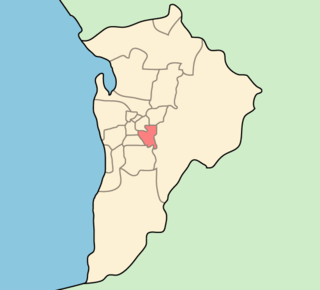
The City of Burnside is a local government area in the South Australian city of Adelaide stretching from the Adelaide Parklands into the Adelaide foothills with an area of 2,753 hectares. It was founded in August 1856 as the District Council of Burnside, the name of a property of an early settler, and was classed as a city in 1943. The LGA is bounded by Adelaide, Adelaide Hills Council, Campbelltown, Mitcham, Norwood Payneham and St Peters and Unley.

Glenside is a suburb in the local government area known as the City of Burnside, Adelaide, South Australia. The suburb is 4.9 kilometres south-east of the Adelaide city centre, home to 2,422 people in a total land area of 1.40 km2.

Mount Osmond is a small suburb of 2,497 people in the South Australian capital city of Adelaide. It is part of the City of Burnside local government area and located in the foothills of the Adelaide Hills, five kilometres south east of the city centre. The suburb is high on the hill of the same name, which is the last hill on the right when approaching Adelaide down the South Eastern Freeway before the road levels out onto the Adelaide Plains. It is bounded to the north by the suburb of Beaumont, to the north-east by Burnside, to the east by Waterfall Gully, to the south by Leawood Gardens/Eagle On The Hill, to the south-west by Urrbrae, to the west by Glen Osmond and to the north-west by St Georges.

<span class="mw-page-title-main">Glen Osmond, South Australia</span> Suburb of Adelaide, South Australia

Glen Osmond is a suburb of Adelaide, South Australia in the City of Burnside which is in the foothills of the Adelaide Hills. It is well known for the road intersection on the western side of the suburb, where the South Eastern Freeway from the Adelaide Hills and the main route from Melbourne splits into National Route A17 Portrush Road, Glen Osmond Road, Adelaide and state route A3 Cross Road west towards the coast and southern suburbs.

Dulwich is a suburb in the City of Burnside, Adelaide, South Australia with a census area population of 2,663 people. The suburb is adjacent to Adelaide's east parklands, and forms part of the western boundary of the City of Burnside. Dulwich is a mix of residential housing and commercial activity–corporate offices and businesses line Fullarton and Greenhill Roads. The suburb is bordered by Rose Park to the north, Toorak Gardens to the east, Glenside to the south and the Adelaide Parklands to the west.

Frewville is a small suburb in the South Australian city of Adelaide. It is three kilometres south-east of Adelaide's central business district (CBD).

<span class="mw-page-title-main">Hazelwood Park, South Australia</span> Suburb of Adelaide, South Australia

Hazelwood Park is an upper class suburb in the City of Burnside, Adelaide, South Australia with a census area population of 1,717 people. The suburb is about 5 kilometres east of the Central business district. Hazelwood Park, a suburban park inside the suburb, is the major attraction in the suburb and is the start of the flat country of the Adelaide Plains at the bottom of the Adelaide Hills. Adjacent Howard Terrace is considered to be the end of the Plains and the start of the foothills. Hazelwood Park includes the Burnside Swimming Centre, a popular site in the summer. Much of the remainder of the suburb is residential but there is a small shopping area along Glynburn Road on the eastern edge. The area was first settled by Europeans in 1848 but has seen many community changes over the years.

<span class="mw-page-title-main">Toorak Gardens, South Australia</span> Suburb of Adelaide, South Australia

Toorak Gardens is a leafy, mainly residential inner eastern suburb of Adelaide, South Australia, located 2 km east of the Adelaide city centre.

Tusmore is a suburb in the inner east of Adelaide, South Australia.

Fullarton is an inner southern suburb of Adelaide, South Australia in the City of Unley.

Marryatville is a small suburb about 4–5 kilometres (2.5–3.1 mi) east of Adelaide's central business district, in the local council area of City of Norwood Payneham St Peters. Comprising low- to medium-density housing, two large schools, a church and several shops, it also has two creeks running through it. The first European settler on the land was George Brunskill in 1839, with part of the land purchased and laid out as a village in 1848 by James Philcox.

Portrush Road is a major arterial route through the eastern suburbs of Adelaide, the capital of South Australia. This name covers many consecutive streets and is not widely known to most drivers except for the southernmost section, as the entire allocation is still best known as by the names of its constituent parts: Hampstead Road, Taunton Road, Ascot Avenue, Lower Portrush Road, and Portrush Road proper. This article will deal with the entire length of the corridor for sake of completion, as well to avoid confusion between declarations. Portrush Road is designated route A17.

<span class="mw-page-title-main">History of the City of Burnside</span> History of area in Adelaide, Australia

The history of the City of Burnside, a local government area in the metropolitan area of Adelaide, spans three centuries. Prior to European settlement Burnside was inhabited by the Kaurna people, who lived around the creeks of the River Torrens during the winter and in the Adelaide Hills during the summer.

<span class="mw-page-title-main">Cross Road, Adelaide</span>

Cross Road is a major arterial road that travels east–west through the inner southern suburbs of the Australian city of Adelaide. It is designated route A3.

<span class="mw-page-title-main">Glen Osmond Road</span>

Glen Osmond Road is a major section of the Princes Highway in the city of Adelaide, South Australia. Connecting the Adelaide city centre with the Adelaide Hills via the South Eastern Freeway; Glen Osmond Road carries half of Adelaide's freight traffic and is the major commuter route from the southern Adelaide Hills. It is designated part of route A1.

<span class="mw-page-title-main">Glenunga International High School</span> High school in Australia

Glenunga International High School (GIHS), formerly Glenunga High School (GHS), is a publicly-funded international school in Adelaide, South Australia. It is located approximately 4 km (2.5 mi) south-east of the Adelaide city centre in the suburb of Glenunga, between L'Estrange and Conyngham Streets, adjoining the major thoroughfare Glen Osmond Road. The school serves the surrounding suburbs of the cities of Unley, Burnside and the Adelaide Hills.

Transitplus was a privately owned public transport company which operated bus services from the South Australian capital Adelaide, to the Adelaide Hills, mainly Mount Barker area. It is part of the Adelaide Metro network. It was a joint venture between TransAdelaide, which also operates the train system in Adelaide and Australian Transit Enterprises. Transitplus was based in Aldgate in the Adelaide Hills and had two depots located in Aldgate and Mount Barker.

References

  1. Australian Bureau of Statistics (28 June 2022). "Glenunga (Suburb and Locality)". Australian Census 2021 QuickStats. Retrieved 28 June 2022.  OOjs UI icon edit-ltr-progressive.svg
  2. "Manning's places of South Australia" by Geoffrey H. Manning, published in 1990".
  3. "Burnside Council 150 Year History eBook" (PDF). Fact 35.
  4. "Commercial Real Estate Properties for Sale in Glenunga, SA 5064". CommercialRealEstate.com.au. Retrieved 31 August 2018.