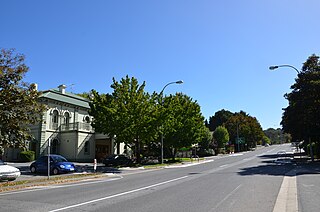
The town of Crafers is in the Adelaide Hills to the south-east of Adelaide, South Australia, considered to be an outer suburb of Adelaide.
Greenhill is a suburb of Adelaide located about 9.3 kilometres (5.8 mi) east of the city centre in the foothills of the Adelaide Hills. Its boundaries were created in October 2001 in respect of the "long established name" with some land being moved into the adjoining suburb of Waterfall Gully in July 2002. The suburb includes Greenhill Recreation Park and the western slopes of Mount Lofty. Greenhill Creek flows through Waterfall Gully and feeds into First Creek.
Port Noarlunga South is a suburb in the Australian state of South Australia located in the Adelaide metropolitan area on the coastline of Gulf St Vincent about 30 kilometres south of the state capital of Adelaide.
Seaford Meadows is a metropolitan suburb of Adelaide, South Australia. It lies within the City of Onkaparinga and has postcode 5169. A shopping centre with a Woolworths Supermarkets was opened in March 2014.

Waitpinga is a locality in the Australian state of South Australia located about 75 kilometres south of the state capital of Adelaide and about 10 kilometres southwest of the municipal seat of Victor Harbor.
Mount Compass is a town and locality in the Australian state of South Australia located in the Mount Lofty Ranges, on the A13 south of Adelaide, and north of Victor Harbor. It is a small community, traditionally supported by farming. Both market gardens and dairy have proved lucrative in the area. At the 2016 census, Mount Compass shared a population of 1,457 with adjoining localities.
Semaphore Park is a suburb in the Australian state of South Australia located in the west of Adelaide on the coastline of Gulf St Vincent. The northern end of the suburb is considered to be located within the Lefevre Peninsula.
Gosse is a locality in the Australian state of South Australia located on Kangaroo Island about 175 kilometres south-west of the state capital of Adelaide city centre.
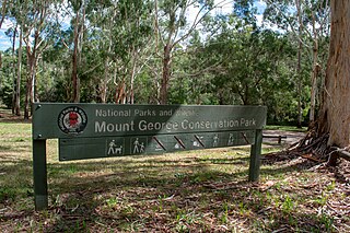
Mount George is a locality in the Australian state of South Australia located about 17 kilometres (11 mi) south-east of the state capital of Adelaide.
Stokes Bay is a locality in the Australian state of South Australia located on the north coast of Kangaroo Island overlooking Investigator Strait about 162 kilometres south-west of the state capital of Adelaide. Its boundaries were created in March 2002 for the “long established name” and includes the Stokes Bay Shack Site. Land use in the locality is principally for agricultural purposes with activity limited on the coastline to the north for conservation purposes. A settlement also occupies land immediately adjoining the bay of the same name. Stokes Bay is located within the federal division of Mayo, the state electoral district of Mawson and the local government area of the Kangaroo Island Council.

Goolwa South is a locality in the Australian state of South Australia located about 67 kilometres south of the state capital of Adelaide on both on the southern continental coastline and the south-western coast of Lake Alexandrina. It occupies the full extent of the Sir Richard Peninsula, land to the immediate west and part of the Goolwa Channel in the lake system to its north.
Antechamber Bay is a locality in the Australian state of South Australia located on the north coast of Dudley Peninsula on Kangaroo Island overlooking Backstairs Passage about 108 kilometres south of the state capital of Adelaide and about 15 kilometres east of Penneshaw.
Deep Creek is a locality in the Australian state of South Australia located on the south coast of the Fleurieu Peninsula overlooking Backstairs Passage about 85 kilometres south of the Adelaide city centre.
Tunkalilla is a locality in the Australian state of South Australia located on the south coast of the Fleurieu Peninsula overlooking Backstairs Passage about 83 kilometres south of the state capital of Adelaide.
Lake Plains is a locality in the Australian state of South Australia located about 64 kilometres south of the Adelaide city centre and 27 kilometres northeast of the centre of Goolwa on the west coastline of Lake Alexandrina.
Tolderol is a locality in the Australian state of South Australia located about 67 kilometres south of the Adelaide city centre, 32 kilometres north-east of the centre of Goolwa and 32 kilometres south-west of the centre of Murray Bridge on the west coastline of Lake Alexandrina.
Mount Jagged is a locality in the Australian state of South Australia located about 55 kilometres south of the state capital of Adelaide and about 16 kilometres north-west and 15 kilometres north respectively of the municipal seats of Goolwa and Victor Harbor.
Kohinoor is a locality in the Australian state of South Australia located on Kangaroo Island about 137 kilometres south-west of the state capital of Adelaide and about 20 kilometres south-east of the municipal seat of Kingscote.
Silverton is a locality in the Australian state of South Australia located about 85 kilometres (53 mi) south of the state capital of Adelaide and about 24 kilometres (15 mi) south-west of the municipal seat in Yankalilla.
Parawa is a locality in the Australian state of South Australia located about 74 kilometres (46 mi) south of the state capital of Adelaide and about 11 kilometres (6.8 mi) south of the municipal seat in Yankalilla.

