Scott Creek Conservation Park is a protected area in the Australian state of South Australia located in the gazetted locality of Dorset Vale about 20 kilometres (12 mi) south of the state capital of Adelaide.

Adelaide Hills Council is a local government area in the Adelaide Hills of South Australia. It is in the hills east of Adelaide, the capital of South Australia. It extends from the South Para Reservoir in the north, to the Mount Bold Reservoir in the south.
Greenhill is a suburb of Adelaide located about 9.3 kilometres (5.8 mi) east of the city centre in the foothills of the Adelaide Hills. Its boundaries were created in October 2001 in respect of the "long established name" with some land being moved into the adjoining suburb of Waterfall Gully in July 2002. The suburb includes Greenhill Recreation Park and the western slopes of Mount Lofty. Greenhill Creek flows through Waterfall Gully and feeds into First Creek.

Old Noarlunga is a suburb in the Australian state of South Australia located about 30 kilometres (19 mi) south of the state capital of Adelaide. Originally settled around 1840, the town retains its village atmosphere in spite of encroaching suburbia.
Christie Downs is a suburb in southern Metropolitan Adelaide within the city of Onkaparinga, South Australia. It has a unique postcode of 5164, and is adjacent to the suburbs of Christies Beach to the west, Noarlunga Centre to the south, Morphett Vale to the east and Lonsdale to the north.
McLaren Flat is a township in the McLaren Vale/Willunga basin south of Adelaide. McLaren Flat is on the sprawling flat land to the east of the town of McLaren Vale on the road to Kangarilla. At the 2016 census, the locality had a population of 1,537 of which 1,121 lived in its town centre.
Ironbank is a semi-rural suburb of Adelaide, South Australia. It is in the City of Onkaparinga and Adelaide Hills Council local government areas, approximately 21.9 km from the Adelaide city centre.

Sellicks Beach, formerly spelt Sellick's Beach, is a suburb in the Australian state of South Australia located within Adelaide metropolitan area about 47 kilometres (29 mi) from the Adelaide city centre. It is an outer southern suburb of Adelaide and is located in the local government area of the City of Onkaparinga at the southern boundary of the metropolitan area. It is known as Witawali or Witawodli by the traditional owners, the Kaurna people, and is of significance as being the site of a freshwater spring said to be created by the tears of Tjilbruke, the creator being.
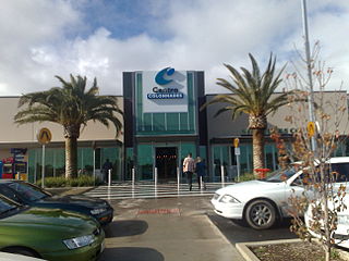
Noarlunga Centre is a suburb in the City of Onkaparinga in the southern suburbs of Adelaide, South Australia. The suburb is mostly commercial, being dominated by the Centro Colonnades shopping centre and the small 'Inspire Noarlunga' estate to the east of Goldsmith Road. The suburb is bordered by Beach Road to the north, Dyson Road to the west Goldsmith Road to the south and the Southern Expressway to the east. Burgess Drive, Seaman Road and David Witton Drive are the main thoroughfares inside the boundaries of the suburb.
Seaford is a metropolitan suburb of Adelaide, South Australia. It lies within the City of Onkaparinga. Seaford railway station is the southern terminus of the Seaford railway line from Adelaide railway station.
Noarlunga Downs is a metropolitan suburb of Adelaide, South Australia. It lies within the City of Onkaparinga and has postcode 5168.
Reynella East is a metropolitan suburb of Adelaide, South Australia. It lies within the City of Onkaparinga and has postcode 5161. It is one of the smallest suburbs in South Australia.

Aldinga Beach is an outer southern suburb of Adelaide, South Australia. It lies within the City of Onkaparinga and has the postcode 5173. At the 2016 census, Aldinga Beach had a population of 10,557. It lies about a kilometre west of the smaller suburb of Aldinga. The beach is a well-known spot for surfing, swimming, scuba diving, and snorkelling during the summer months. It overlooks an aquatic reserve which has been created to safeguard a unique reef formation.
Port Noarlunga South is a suburb in the Australian state of South Australia located in the Adelaide metropolitan area on the coastline of Gulf St Vincent about 30 kilometres south of the state capital of Adelaide.
Willunga South is a town south of Adelaide, South Australia in the City of Onkaparinga local government area. Willunga South is established in the Sellicks Hill Range and is located at the base of Delabole Hill. It is approximately 48 km from the Adelaide CBD.
Whites Valley is a semi-rural suburb of Adelaide, South Australia. It is home to many vineyards.
Montacute is a small regional area in the Adelaide Hills, South Australia. Montacute is located on Fifth Creek, and the mostly-rural suburb extends from Rostrevor in the west to Lenswood in the east, bounded on the north by Castambul and on the south by Norton Summit and Cherryville. The small town of Montacute Heights is located on top of the ridge between Fifth and Sixth Creeks. Montacute is reached from Adelaide via Montacute Road.
Scott Creek is a locality in the Adelaide Hills about 24 kilometres (15 mi) southeast of Adelaide in South Australia. It includes the "ceased Government Town" of Cotton.
Mylor Conservation Park is a protected area located in the Australian state of South Australia in the suburb of Mylor in the Adelaide Hills state government region about 19 kilometres (12 mi) south-east of the state capital of Adelaide and about 1 kilometre (0.62 mi) north-east of the town of Mylor.
Coombe is a locality in the Australian state of South Australia located about 186 kilometres (116 mi) south-east of the state capital of Adelaide and about 105 kilometres (65 mi) south-east of the municipal seat in Tailem Bend.
