
The City of Onkaparinga is a local government area (LGA) located on the southern fringe of Adelaide, South Australia. It is named after the Onkaparinga River, whose name comes from Ngangkiparinga, a Kaurna word meaning women's river. It is the largest LGA in South Australia, with a population of over 170,000 people in both urban and rural communities and is also geographically expansive, encompassing an area of 518.3 km². The council is headquartered in the Noarlunga Centre with area offices situated in Aberfoyle Park, Woodcroft and Willunga.
Trott Park is a suburb in the south of Adelaide, South Australia. It has a population of 3,503 people.

Old Noarlunga is a suburb in the Australian state of South Australia located about 30 kilometres (19 mi) south of the state capital of Adelaide. Originally settled around 1840, the town retains its village atmosphere in spite of encroaching suburbia.
McLaren Flat is a township in the McLaren Vale/Willunga basin south of Adelaide. McLaren Flat is on the sprawling flat land to the east of the town of McLaren Vale on the road to Kangarilla. At the 2016 census, the locality had a population of 1,537 of which 1,121 lived in its town centre.
Willunga is a town located to the south of Adelaide, South Australia in the City of Onkaparinga local government area, 47 km from the Adelaide city centre. This town has been considered a suburb of the Adelaide metropolitan area, and it is located within the McLaren Vale wine-growing region. In the 2016 census, Willunga recorded a population of 2,308.
Chain of Ponds is a locality and former town near Adelaide, South Australia. It is located in the Adelaide Hills Council local government area.

Mount Torrens is a town in the eastern Adelaide Hills region of South Australia, 46 kilometres east-north-east of the state capital, Adelaide and 8 km east of Lobethal. It is located in the Adelaide Hills Council and the Mid Murray Council local government areas. At the 2006 census, Mount Torrens had a population of 337.

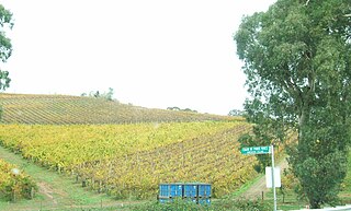
McLaren Vale is a town and locality in the Australian state of South Australia located about 33 kilometres (21 mi) south of the Adelaide city centre and about 9 kilometres (5.6 mi) south of the municipal seat at Noarlunga Centre.
Ironbank is a semi-rural suburb of Adelaide, South Australia. It is in the City of Onkaparinga and Adelaide Hills Council local government areas, approximately 21.9 km from the Adelaide city centre.

Sellicks Beach, formerly spelt Sellick's Beach, is a suburb in the Australian state of South Australia located within Adelaide metropolitan area about 47 kilometres (29 mi) from the Adelaide city centre. It is an outer southern suburb of Adelaide and is located in the local government area of the City of Onkaparinga at the southern boundary of the metropolitan area. It is known as Witawali or Witawodli by the traditional owners, the Kaurna people, and is of significance as being the site of a freshwater spring said to be created by the tears of Tjilbruke, the creator being.

Aldinga Beach is an outer southern suburb of Adelaide, South Australia. It lies within the City of Onkaparinga and has the postcode 5173. At the 2016 census, Aldinga Beach had a population of 10,557. It lies about a kilometre west of the smaller suburb of Aldinga. The beach is a well-known spot for surfing, swimming, scuba diving, and snorkelling during the summer months. It overlooks an aquatic reserve which has been created to safeguard a unique reef formation.
Chandlers Hill is a suburb of Adelaide, South Australia. It lies within the City of Onkaparinga and has postcode 5159.
Dorset Vale is a rural locality near Adelaide, South Australia. It straddles three local government areas adjacent to the Onkaparinga River, being within the Adelaide Hills, Mount Barker and the Onkaparinga council areas. The precise boundaries were set in April 1994 and extended in November 2003 for the long-established name. The first post office in the area was given the English name Dorset Vale circa 1850, but it was locally known as "Scotts Bottom" as it was downstream from Scott Creek. Scotts Bottom School opened in 1930, its name was changed to Dorset Vale in 1937 and it closed in 1944.

Kangarilla is a small rural town and locality around 33 km (21 mi) from Adelaide city centre, in South Australia. The area, formerly inhabited by Kaurna people, was settled by Europeans in 1840, not long after the British colonisation of South Australia. Today it lies within the City of Onkaparinga local government area, and has postcode 5157. At the 2016 census, Kangarilla had a population of 896.

Port Willunga is a semi-rural suburb of Adelaide, South Australia. It is known as Wirruwarrungga or Ruwarunga by the traditional owners, the Kaurna people, and is of significance as being the site of a freshwater spring said to be created by the tears of Tjilbruke, the creator being.

Sellicks Hill – formerly spelt Sellick's Hill – is a semi-rural suburb of Adelaide, South Australia. It lies within both the City of Onkaparinga and the District Council of Yankalilla. Before the British colonisation of South Australia, the Sellicks Hill area, was inhabited by the Kaurna people. Sellick's Hill Post Office opened on 2 July 1860.
Whites Valley is a semi-rural suburb of Adelaide, South Australia. It is home to many vineyards.
Humbug Scrub is a locality north of Adelaide, South Australia in the local government areas of the Adelaide Hills Council and the City of Playford which contains the southern third of Para Wirra Conservation Park.
Adelaide Airport is a suburb in the City of West Torrens west of the Adelaide City Centre. The suburb was proclaimed in 1991. Almost the entire area of the suburb is taken up by the Adelaide Airport and associated businesses. There is also Harbour Town shopping centre on the western side of the suburb.
Kuitpo is a locality in the Alexandrina Council area.
