
The City of Onkaparinga is a local government area (LGA) located on the southern fringe of Adelaide, South Australia. It is named after the Onkaparinga River, whose name comes from Ngangkiparinga, a Kaurna word meaning women's river. It is the largest LGA in South Australia, with a population of over 170,000 people in both urban and rural communities and is also geographically expansive, encompassing an area of 518.3 km2. The council is headquartered in the Noarlunga Centre with area offices situated in Aberfoyle Park, Woodcroft and Willunga.

Aldinga is a suburb of Adelaide in South Australia located about 45 kilometres south of the Adelaide city centre in the City of Onkaparinga. It is a small suburb, about a kilometre east of the edge of the larger suburb of Aldinga Beach, and about 3 km (1.9 mi) from the beachfront.

The Onkaparinga River, known as Ngangkiparri or Ngangkiparingga in the Kaurna language, is a river located in the Southern Adelaide region in the Australian state of South Australia. Rising in the Mount Lofty Ranges, the river's estuary extends from Old Noarlunga to the river's mouth between the suburbs of Port Noarlunga and Port Noarlunga South.
South Road and its southern section as Main South Road outside of Adelaide is a major north–south conduit connecting Adelaide and the Fleurieu Peninsula, in South Australia. It is one of Adelaide's most important arterial and bypass roads. As South Road, it is designated part of route A2 within suburban Adelaide. As Main South Road, it is designated part of routes A13 and B23.

Maslin Beach is a southern coastal suburb of Adelaide, South Australia. It is located in the City of Onkaparinga.
Christie Downs is a suburb in southern Metropolitan Adelaide within the city of Onkaparinga, South Australia. It has a unique postcode of 5164, and is adjacent to the suburbs of Christies Beach to the west, Noarlunga Centre to the south, Morphett Vale to the east and Lonsdale to the north.

Lonsdale is an industrial suburb south of Adelaide, South Australia, within the City of Onkaparinga.

Christies Beach is a seaside suburb in the southern Adelaide metropolitan area, within the City of Onkaparinga. The area is scenic and hence popular with photographers as Witton Bluff provides a natural vantage point over the entire suburb and beyond.

Sellicks Beach, formerly spelt Sellick's Beach, is a suburb in the Australian state of South Australia located within Adelaide metropolitan area about 47 kilometres (29 mi) from the Adelaide city centre. It is an outer southern suburb of Adelaide and is located in the local government area of the City of Onkaparinga at the southern boundary of the metropolitan area. It is known as Witawali or Witawodli by the traditional owners, the Kaurna people, and is of significance as being the site of a freshwater spring said to be created by the tears of Tjilbruke, the creator being.

Moana is an outer coastal suburb in the south of Adelaide, South Australia. The suburb is approximately 36.4 km from the Adelaide city centre. It lies within the City of Onkaparinga local government area, and neighbours the suburbs Seaford, Maslin Beach, Seaford Rise and Port Noarlunga It is divided into two by Pedler Creek and the associated sand dune reserve. The beach is often referred to as Moana Beach.
Seaford is a metropolitan suburb of Adelaide, South Australia. It lies within the City of Onkaparinga. Seaford railway station is the southern terminus of the Seaford railway line from Adelaide railway station.

Seaford Rise is a metropolitan suburb of Adelaide, South Australia. It lies within the City of Onkaparinga. Its boundaries are formed by Griffiths Drive in the north, Commercial Road in the west, Main South Road in the east, and by an arbitrary border with Maslin Beach in the south.

Onkaparinga Hills is a southern suburb of Adelaide, in the City of Onkaparinga, South Australia. It covers an area of approximately 22 square kilometres . It has a population of 2534 people. It is a leafy suburb that includes parts of the Onkaparinga River National Park.
Hackham West is an outer southern suburb of Adelaide, South Australia. It is located in the City of Onkaparinga.
Huntfield Heights is a metropolitan suburb of Adelaide, South Australia. It lies within the City of Onkaparinga and has postcode 5163. The borders of this suburb are Honeypot Road to the north, Main South Road marks the eastern and the southern border, and the Southern Expressway marks the most westerly border. Huntfield Heights used to be the southern half of Hackham West. In the late 1990s it was renamed, after former Noarlunga mayor Walter Morris Hunt.
Port Noarlunga South is a suburb in the Australian state of South Australia located in the Adelaide metropolitan area on the coastline of Gulf St Vincent about 30 kilometres south of the state capital of Adelaide.
Seaford Meadows is a metropolitan suburb of Adelaide, South Australia. It lies within the City of Onkaparinga and has postcode 5169. A shopping centre with a Woolworths Supermarkets was opened in March 2014.
New Port is a north-western suburb of Adelaide, South Australia. It is located in the City of Port Adelaide Enfield.
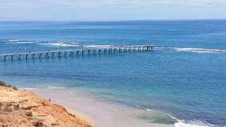
Port Noarlunga Reef Aquatic Reserve is a marine protected area in the Australian state of South Australia located in waters in Gulf St Vincent adjoining the Adelaide metropolitan area and including part of the Onkaparinga River about 28 kilometres (17 mi) south-west of the state capital of Adelaide.
Mount Jagged is a locality in the Australian state of South Australia located about 55 kilometres south of the state capital of Adelaide and about 16 kilometres north-west and 15 kilometres north respectively of the municipal seats of Goolwa and Victor Harbor.
