Port Noarlunga South, South Australia

Last updated

Port Noarlunga South
Adelaide,  South Australia
Australia South Australia location map.svg
Red pog.svg
Port Noarlunga South
Coordinates 35°09′49″S138°28′34″E / 35.163490°S 138.4762°E / -35.163490; 138.4762 Coordinates: 35°09′49″S138°28′34″E / 35.163490°S 138.4762°E / -35.163490; 138.4762
Population3,058 (SAL 2021) [1]
Established1923 [2]
Postcode(s) 5167 [3]
Location30 km (19 mi) from Adelaide
LGA(s) City of Onkaparinga [2]
Region Southern Adelaide [4]
County Adelaide [5]
State electorate(s) Kaurna [6]
Federal division(s) Kingston [7]
Mean max tempMean min tempAnnual rainfall
21.7 °C
71 °F
12.8 °C
55 °F
448.7 mm
17.7 in
Suburbs around Port Noarlunga South:
Gulf St Vincent Port Noarlunga Noarlunga Downs
Gulf St Vincent Port Noarlunga South Noarlunga Downs
Seaford Meadows
Gulf St Vincent Seaford Seaford Meadows
FootnotesAdjoining suburbs [8]
Climate [9]
Coordinates [2]
Location [3]

Port Noarlunga South is a suburb in the Australian state of South Australia located in the Adelaide metropolitan area on the coastline of Gulf St Vincent about 30 kilometres (19 miles) south of the state capital of Adelaide. [2] [3]

Contents

Port Noarlunga South started as a private sub-division in 1923 with portions gazetted with the names Paringa and Port Onkaparinga. A portion of land was added to the suburb in 1960 from an area known as Onkaparinga and was subsequently removed in 1995 to create the suburb of Seaford Meadows. In April 2001, the South Port Surf Life Saving Club submitted a proposal to rename parts of both the suburbs of Port Noarlunga and Port Noarlunga South as South Port. However, this proposal was withdrawn in August 2001 following discussions with the City of Onkaparinga regarding "locational identification issues " and replace with a request to "investigate the naming of South Port Beach." [2]

Port Noarlunga South is bounded by the centre of the channel of the Onkaparinga River to the north, the coastline with Gulf St Vincent to the west, Aldam Road to the South and to the east by Commercial Road in part in the south, the centre of the Onkaparinga River in part and a line connecting both parts. [2] Land use within the suburb consists of residential on its west side and 'open space' for land located within the Onkaparinga River Recreation Park on its east side. [2]

Port Noarlunga South is located within the federal Division of Kingston, the state electoral district of Kaurna and the local government area of the City of Onkaparinga. [2] [6] [7]

Onkaparinga Community Playground

At the northern end of the suburb, there is a large community playground located on land bounded by Saltfeet Street to the west and the River Onkaparinga in the east. [10] This is a community built playground and as such is unique to South Australia. The sum of A$250 000 was raised from community sponsorship before the playground was built using community labour over the period of 18–23 June 2002. This project began after research by "Living Neighbourhood" in the suburb of Christies Beach. There was a public meeting, after which a non-profit incorporated body was formed for the project.[ citation needed ] As of 2013, the City of Onkaparinga had not decided on an official name with the result that the following names are in use – Jubilee Park and A E Young Reserve names by the South Australian government and Adventure Playground in use by the local community. [10]

See also

Related Research Articles

<span class="mw-page-title-main">City of Onkaparinga</span> Local government area in South Australia

The City of Onkaparinga is a local government area (LGA) located on the southern fringe of Adelaide, South Australia. It is named after the Onkaparinga River, whose name comes from Ngangkiparinga, a Kaurna word meaning women's river. It is the largest LGA in South Australia, with a population of over 170,000 people in both urban and rural communities and is also geographically expansive, encompassing an area of 518.3 km². The council is headquartered in the Noarlunga Centre with area offices situated in Aberfoyle Park, Woodcroft and Willunga.

<span class="mw-page-title-main">Aldinga, South Australia</span> Suburb of City of Onkaparinga, South Australia

Aldinga is a suburb of Adelaide in South Australia located about 45 kilometres south of the Adelaide city centre in the City of Onkaparinga. it is a small suburb, about a kilometre east of the edge of the larger suburb of Aldinga Beach, and about 3 km (1.9 mi) from the beachfront.

<span class="mw-page-title-main">Onkaparinga River</span> River in South Australia

The Onkaparinga River, known as Ngangkiparri or Ngangkiparingga in the Kaurna language, is a river located in the Southern Adelaide region in the Australian state of South Australia. Rising in the Mount Lofty Ranges, the river's estuary extends from Old Noarlunga to the river's mouth between the suburbs of Port Noarlunga and Port Noarlunga South.

<span class="mw-page-title-main">Old Noarlunga, South Australia</span> Suburb of Adelaide, South Australia

Old Noarlunga is a suburb in the Australian state of South Australia located about 30 kilometres (19 mi) south of the state capital of Adelaide. Originally settled around 1840, the town retains its village atmosphere in spite of encroaching suburbia.

<span class="mw-page-title-main">Port Noarlunga, South Australia</span> Coastal suburb of Adelaide, South Australia

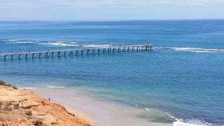
Port Noarlunga is a suburb in the City of Onkaparinga, South Australia. It is a small sea-side suburb, with a population of 2,918, about 30 kilometres to the south of the Adelaide city centre and was originally created as a sea port. This area is now popular as a holiday destination or for permanent residents wishing to commute to Adelaide or work locally. There is a jetty that connects to a 1.6 kilometres long natural reef that is exposed at low tide. The beach is large and very long and has reasonable surfing in the South Port area whose name is taken from its location - "South of the Port".

Christie Downs is a suburb in southern Metropolitan Adelaide within the city of Onkaparinga, South Australia. It has a unique postcode of 5164, and is adjacent to the suburbs of Christies Beach to the west, Noarlunga Centre to the south, Morphett Vale to the east and Lonsdale to the north.

<span class="mw-page-title-main">Christies Beach, South Australia</span> Suburb of Adelaide, South Australia

Christies Beach is a seaside suburb in the southern Adelaide metropolitan area, within the City of Onkaparinga. The area is scenic and hence popular with photographers as Witton Bluff provides a natural vantage point over the entire suburb and beyond.

<span class="mw-page-title-main">Lefevre Peninsula</span> Place in South Australia

The Lefevre Peninsula is a peninsula located in the Australian state of South Australia located about 15 kilometres (9.3 mi) northwest of the Adelaide city centre. It is a narrow sand spit of about 30 square kilometres (12 sq mi) running north from its connection to the mainland.

<span class="mw-page-title-main">Sellicks Beach, South Australia</span> Suburb of City of Onkaparinga, South Australia

Sellicks Beach, formerly spelt Sellick's Beach, is a suburb in the Australian state of South Australia located within Adelaide metropolitan area about 47 kilometres (29 mi) from the Adelaide city centre. It is an outer southern suburb of Adelaide and is located in the local government area of the City of Onkaparinga at the southern boundary of the metropolitan area. It is known as Witawali or Witawodli by the Traditional Owners, the Kaurna people, and is of significance as being the site of a freshwater spring said to be created by the tears of Tjilbruke, the creator being.

<span class="mw-page-title-main">Noarlunga Centre, South Australia</span> Suburb of Adelaide, South Australia

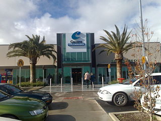
Noarlunga Centre is a suburb in the City of Onkaparinga in the southern suburbs of Adelaide, South Australia. The suburb is mostly commercial, being dominated by the Centro Colonnades shopping centre and the small 'Inspire Noarlunga' estate to the east of Goldsmith Road. The suburb is bordered by Beach Road to the north, Dyson Road to the west Goldsmith Road to the south and the Southern Expressway to the east. Burgess Drive, Seaman Road and David Witton Drive are the main thoroughfares inside the boundaries of the suburb.

<span class="mw-page-title-main">Moana, South Australia</span> Suburb of Adelaide, South Australia

Moana is an outer coastal suburb in the south of Adelaide, South Australia. The suburb is approximately 36.4 km from the Adelaide city centre. It lies within the City of Onkaparinga local government area, and neighbours the suburbs Seaford, Maslin Beach, Seaford Rise and Port Noarlunga It is divided into two by Pedlar Creek and the associated sand dune reserve. The beach is often referred to as Moana Beach.

Seaford is a metropolitan suburb of Adelaide, South Australia. It lies within the City of Onkaparinga. Seaford railway station is the southern terminus of the Seaford railway line from Adelaide railway station.

Noarlunga Downs is a metropolitan suburb of Adelaide, South Australia. It lies within the City of Onkaparinga and has postcode 5168.

O'Sullivan Beach is a seaside suburb in the southern Adelaide metropolitan area, within the City of Onkaparinga. O'Sullivan Beach has a unique postcode of 5166.

<span class="mw-page-title-main">Aldinga Beach, South Australia</span> Suburb of City of Onkaparinga, South Australia

Aldinga Beach is an outer southern suburb of Adelaide, South Australia. It lies within the City of Onkaparinga and has the postcode 5173. At the 2016 census, Aldinga Beach had a population of 10,557. It lies about a kilometre west of the smaller suburb of Aldinga. The beach is a well-known spot for surfing, swimming, scuba diving, and snorkelling during the summer months. It overlooks an aquatic reserve which has been created to safeguard a unique reef formation.

<span class="mw-page-title-main">Kangarilla, South Australia</span> Town in South Australia

Kangarilla is a small rural town and locality around 33 km (21 mi) from Adelaide city centre, in South Australia. The area, formerly inhabited by Kaurna people, was settled by Europeans in 1840, not long after the British colonisation of South Australia. Today it lies within the City of Onkaparinga local government area, and has postcode 5157. At the 2016 census, Kangarilla had a population of 896.

Seaford Meadows is a metropolitan suburb of Adelaide, South Australia. It lies within the City of Onkaparinga and has postcode 5169. A shopping centre with a Woolworths Supermarkets was opened in March 2014.

<span class="mw-page-title-main">Sellicks Hill, South Australia</span> Suburb of City of Onkaparinga, District Council of Yankalilla, South Australia

Sellicks Hill – formerly spelt Sellick's Hill – is a semi-rural suburb of Adelaide, South Australia. It lies within both the City of Onkaparinga and the District Council of Yankalilla. Before the British colonisation of South Australia, the Sellicks Hill area, was inhabited by the Kaurna people. Sellick's Hill Post Office opened on 2 July 1860.

<span class="mw-page-title-main">Port Noarlunga Reef Aquatic Reserve</span> Protected area in South Australia

Port Noarlunga Reef Aquatic Reserve is a marine protected area in the Australian state of South Australia located in waters in Gulf St Vincent adjoining the Adelaide metropolitan area and including part of the Onkaparinga River about 28 kilometres (17 mi) south-west of the state capital of Adelaide.

<span class="mw-page-title-main">Hundred of Willunga</span> Cadastral in South Australia

The Hundred of Willunga is a cadastral unit of hundred covering the extreme south suburbs of the Adelaide metropolitan area. It is one of the eleven hundreds of the County of Adelaide. It was named in 1846 by Governor Frederick Robe probably deriving from a Kaurna/Ngarrindjeri place label willannga, meaning place of green trees.

References

  1. Australian Bureau of Statistics (28 June 2022). "Port Noarlunga South (Suburb and Locality)". Australian Census 2021 QuickStats. Retrieved 28 June 2022.  OOjs UI icon edit-ltr-progressive.svg
  2. 1 2 3 4 5 6 7 8 "Search result for "Port Noarlunga South (SUB)" (Record no. SA0040640) with the following layers selected – "Suburbs and Localities" and " Place names (gazetteer)"". Property Location Browser. Government of South Australia. Archived from the original on 12 October 2016. Retrieved 2 November 2016.
  3. 1 2 3 "Port Noarlunga South, South Australia (Postcode)". postcodes-australia.com. Retrieved 2 November 2016.
  4. "Southern Adelaide SA Government region" (PDF). The Government of South Australia. Retrieved 17 April 2017.
  5. "Search result for "County of Adelaide, CNTY" with the following data sets selected – "Counties" and "Local Government Areas"". Property Location SA Map Viewer. Government of South Australia. Retrieved 24 April 2017.
  6. 1 2 "Electoral district of Kaurna, 2014 State election boundaries". ELECTORAL COMMISSION SA. Retrieved 11 October 2016.
  7. 1 2 "Map of the Federal division of Kingston" (PDF). Australian Electoral Commission. 2011. Retrieved 28 July 2015.
  8. "City of Onkaparinga suburb boundaries map". City of Onkaparinga. 9 January 2014. Archived from the original on 24 September 2015. Retrieved 8 October 2014.
  9. "Monthly climate statistics: Summary statistics Noarlunga (nearest weather station)". Commonwealth of Australia , Bureau of Meteorology. Retrieved 11 October 2016.
  10. 1 2 "Search result for "Jubilee Park (Reserve)" (Record no. SA0067248) with the following layers selected – "Suburbs and Localities" and " Place names (gazetteer)"". Property Location Browser. Government of South Australia. Archived from the original on 12 October 2016. Retrieved 13 November 2016.