
Aldinga is a suburb of Adelaide in South Australia located about 45 kilometres south of the Adelaide city centre in the City of Onkaparinga. It is a small suburb, about a kilometre east of the edge of the larger suburb of Aldinga Beach, and about 3 km (1.9 mi) from the beachfront.
Upper Sturt is a suburb in the inner south of Adelaide, South Australia. The suburb is nestled in the lower reaches of the Mount Lofty Ranges with the Western Half located in the City of Mitcham local government area, and the eastern portion located in the Adelaide Hills Council Local Government Area.

Cheltenham is a suburb of Adelaide, South Australia. It is located on Kaurna Land in the City of Charles Sturt.

Reynella is a metropolitan suburb of Adelaide, South Australia.

Bowden is an inner northern suburb of Adelaide, South Australia. It is located in the City of Charles Sturt.

Valley View is a suburb of Adelaide, South Australia. It spans three separate local government areas. They are the City of Salisbury, the City of Port Adelaide Enfield, and the City of Tea Tree Gully. The suburb's boundaries are defined by the intersection of Walkleys, Grand Junction and North East Roads in the south, and Wright and Kelly Roads in the north and east.

Ovingham is an inner northern suburb of Adelaide, South Australia. It is located in the cities of Charles Sturt and Prospect.
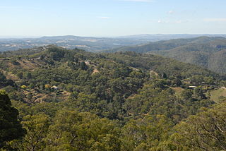
Ironbank is a semi-rural suburb of Adelaide, South Australia. It is in the City of Onkaparinga and Adelaide Hills Council local government areas, approximately 21.9 km from the Adelaide city centre.
Coromandel Valley is a semirural south-eastern suburb of Adelaide, South Australia. It straddles the City of Mitcham and the City of Onkaparinga council areas, with the Sturt River being the boundary between the two council areas.

Albert Park is a suburb of Adelaide, South Australia. It is located in the City of Charles Sturt.

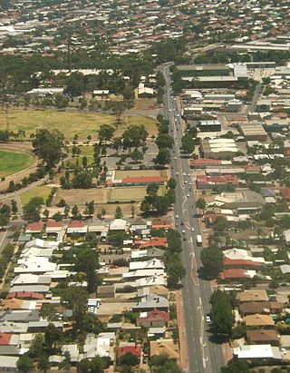
Seaton is a suburb of Adelaide, South Australia, located in the western suburbs near Findon, Grange and West Lakes. Seaton is home to the Royal Adelaide Golf Club. Main roads including Tapleys Hill Road and Grange Road go through the suburb.
Seaford is a metropolitan suburb of Adelaide, South Australia. It lies within the City of Onkaparinga. Seaford railway station is the southern terminus of the Seaford railway line from Adelaide railway station.

Aldinga Beach is an outer southern suburb of Adelaide, South Australia. It lies within the City of Onkaparinga and has the postcode 5173. At the 2016 census, Aldinga Beach had a population of 10,557. It lies about a kilometre west of the smaller suburb of Aldinga. The beach is a well-known spot for surfing, swimming, scuba diving, and snorkelling during the summer months. It overlooks an aquatic reserve which has been created to safeguard a unique reef formation.

Kangarilla is a small rural town and locality around 33 km (21 mi) from Adelaide city centre, in South Australia. The area, formerly inhabited by Kaurna people, was settled by Europeans in 1840, not long after the British colonisation of South Australia. Today it lies within the City of Onkaparinga local government area, and has postcode 5157. At the 2016 census, Kangarilla had a population of 896.

Sellicks Hill – formerly spelt Sellick's Hill – is a semi-rural suburb of Adelaide, South Australia. It lies within both the City of Onkaparinga and the District Council of Yankalilla. Before the British colonisation of South Australia, the Sellicks Hill area, was inhabited by the Kaurna people. Sellick's Hill Post Office opened on 2 July 1860.

Allenby Gardens is a western suburb of Adelaide, South Australia. It is located in the City of Charles Sturt.
Cherryville is a small town in the Adelaide Hills, South Australia. It was named in around 1840 after the native cherry trees that grew in the area, although some historians claim that it was not named until 1892, when horticultural cherry plantings became widespread in the area. Prior to this, land holdings were typically of around 100 acres (40 ha) and used primarily for pastoralism or small-scale vegetable gardens.
West Hindmarsh is a suburb of Adelaide, located in the City of Charles Sturt local government area. It is around 4 km west northwest of the Adelaide city centre. It is bounded on the south by the River Torrens, east by South Road, north by Port Road and west by streets separating it from the suburb of Welland which has the same north and south boundaries. Grange Road crosses the middle of the suburb.
The Range is a rural locality, south of Adelaide, South Australia. The Range Post Office opened on 1 June 1947 and closed in 1962.
Franklyn is a rural locality in the Mid North region of South Australia, situated in the Regional Council of Goyder. It was established in August 2000, when boundaries were formalised for the "long established local name". It comprises the northern section of the cadastral Hundred of Wonna. The name stems from a Franklyn House in Devonshire.
