McLaren Flat is a township in the McLaren Vale/Willunga basin south of Adelaide. McLaren Flat is on the sprawling flat land to the east of the town of McLaren Vale on the road to Kangarilla. At the 2016 census, the locality had a population of 1,537 of which 1,121 lived in its town centre.

McLaren Vale is a town and locality in the Australian state of South Australia located about 33 kilometres (21 mi) south of the Adelaide city centre and about 9 kilometres (5.6 mi) south of the municipal seat at Noarlunga Centre.
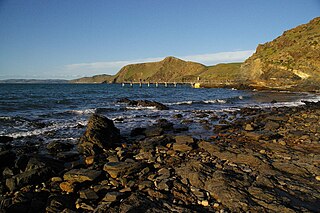
Second Valley is a coastal town on the Fleurieu Peninsula in South Australia.

Sellicks Beach, formerly spelt Sellick's Beach, is a suburb in the Australian state of South Australia located within Adelaide metropolitan area about 47 kilometres (29 mi) from the Adelaide city centre. It is an outer southern suburb of Adelaide and is located in the local government area of the City of Onkaparinga at the southern boundary of the metropolitan area. It is known as Witawali or Witawodli by the traditional owners, the Kaurna people, and is of significance as being the site of a freshwater spring said to be created by the tears of Tjilbruke, the creator being.

Sellicks Hill – formerly spelt Sellick's Hill – is a semi-rural suburb of Adelaide, South Australia. It lies within both the City of Onkaparinga and the District Council of Yankalilla. Before the British colonisation of South Australia, the Sellicks Hill area, was inhabited by the Kaurna people. Sellick's Hill Post Office opened on 2 July 1860.
Tatachilla is a semi-rural suburb of Adelaide, South Australia. It lies within the City of Onkaparinga. It is the location of the Tatachilla Lutheran College.
Willunga South is a town south of Adelaide, South Australia in the City of Onkaparinga local government area. Willunga South is established in the Sellicks Hill Range and is located at the base of Delabole Hill. It is approximately 48 km from the Adelaide CBD.
Delamere is a locality in the Australian state of South Australia located on the south coast of the Fleurieu Peninsula about 80 kilometres (50 mi) south of the state capital of Adelaide and about 18 kilometres (11 mi) south-west of the municipal seat of Yankalilla. It includes what was once a neighbouring village of Bullaparinga.
Myponga is a settlement in South Australia. At the 2016 census, the locality had a population of 744, of whom 393 lived in its town centre. Myponga is located within the federal division of Mayo, the state electoral district of Mawson, and the local government area of the District Council of Yankalilla.
Brown Beach is a locality in the Australian state of South Australia located on the north coast of Dudley Peninsula on Kangaroo Island overlooking Nepean Bay about 119 kilometres south-west of the state capital of Adelaide. Its boundaries were created in March 2002. The name is derived from a nearby beach of the same name. As of 2015, Brown Beach consists of a strip of land located between the coastline with Nepean Bay and the Hog Bay Road. The locality is zoned for conservation purposes with the view of providing limited built development intended principally for tourism uses, which has a minimal impact and where provided, complements the environment of the locality. Brown Beach is located within the federal division of Mayo, the state electoral district of Mawson and the local government area of the Kangaroo Island Council.
Stokes Bay is a locality in the Australian state of South Australia located on the north coast of Kangaroo Island overlooking Investigator Strait about 162 kilometres south-west of the state capital of Adelaide. Its boundaries were created in March 2002 for the “long established name” and includes the Stokes Bay Shack Site. Land use in the locality is principally for agricultural purposes with activity limited on the coastline to the north for conservation purposes. A settlement also occupies land immediately adjoining the bay of the same name. Stokes Bay is located within the federal division of Mayo, the state electoral district of Mawson and the local government area of the Kangaroo Island Council.
Bay of Shoals is a locality in the Australian state of South Australia located on the north coast of Kangaroo Island overlooking the Bay of Shoals about 121 kilometres south-west of the state capital of Adelaide and about 7 kilometres north of the municipal seat of Kingscote.
Deep Creek is a locality in the Australian state of South Australia located on the south coast of the Fleurieu Peninsula overlooking Backstairs Passage about 85 kilometres south of the Adelaide city centre.
Tunkalilla is a locality in the Australian state of South Australia located on the south coast of the Fleurieu Peninsula overlooking Backstairs Passage about 83 kilometres south of the state capital of Adelaide.
Kohinoor is a locality in the Australian state of South Australia located on Kangaroo Island about 137 kilometres south-west of the state capital of Adelaide and about 20 kilometres south-east of the municipal seat of Kingscote.
Birchmore is a locality in the Australian state of South Australia located on Kangaroo Island about 138 kilometres south-west of the state capital of Adelaide and about 20 kilometres south-east of the municipal seat of Kingscote.
Duncan is a locality in the Australian state of South Australia located on Kangaroo Island about 162 kilometres south-west of the state capital of Adelaide and about 49 kilometres west of the municipal seat of Kingscote.
Menzies is a locality in the Australian state of South Australia located on Kangaroo Island about 136 kilometres south-west of the state capital of Adelaide and about 19 kilometres west of the municipal seat of Kingscote.
Silverton is a locality in the Australian state of South Australia located about 85 kilometres (53 mi) south of the state capital of Adelaide and about 24 kilometres (15 mi) south-west of the municipal seat in Yankalilla.
Parawa is a locality in the Australian state of South Australia located about 74 kilometres (46 mi) south of the state capital of Adelaide and about 11 kilometres (6.8 mi) south of the municipal seat in Yankalilla.
