
The City of Melville is a local government area in the southern suburbs of the Western Australian capital city of Perth, east of the port city of Fremantle and about 12 kilometres (7.5 mi) south of Perth's central business district. The City covers an area of 52.73 square kilometres (20.36 sq mi) and had a population of about 98,000 as at the 2016 Census.

Bull Creek is a suburb of Perth, Western Australia, located within the local government area of City of Melville. The suburb lies to the south of a creek of the same name, which flows into the Canning River.

Burnside is suburb in the City of Burnside council area in the eastern suburbs of Adelaide. It is primarily a residential suburb. Burnside is 7.5 kilometres (4.7 mi) east of the Adelaide city centre by road.
South Windsor is a suburb of the town of Windsor in north west Sydney in the state of New South Wales, Australia. It is generally bounded in the west by Rickabys Creek and in the east by South Creek, both tributaries of the Hawkesbury River. It is also home of Bede Polding College, a Catholic secondary school.
Rossmoyne is a suburb of Perth, Western Australia, within the City of Canning. Rossmoyne is located 14 kilometres (8.7 mi) south of central Perth, and is bounded by Leach Highway to the south, the Bull Creek to the west, the Canning River to the north, and Shelley to the east.
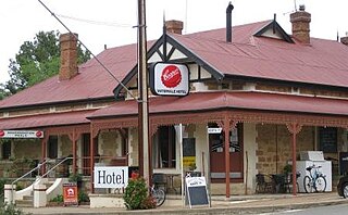
Watervale is a town on the Horrocks Highway in the Clare Valley, South Australia, approximately 9 kilometres north of Auburn and 15 kilometres south of Clare. It is surrounded by a number of small wineries and several B&Bs. The Riesling Trail runs past the town to the west, between the Highway and the Skilly Hills. The town has a number of 19th-century heritage buildings, including the former Stanley Grammar School, which now provides private bed and breakfast accommodation.
Paracombe is a small town near Adelaide, South Australia. At the 2011 census, Paracombe had a population of 343.

Mooney Mooney Creek is a suburb of the Central Coast region of New South Wales, Australia, located 60 kilometres (37 mi) north of Sydney along both sides of the river after which it is named. It is part of the Central Coast Council local government area.

Echunga is a small town in the Adelaide Hills located 34 kilometres (21 mi) south-east of Adelaide in South Australia.
Meadows is a town in the Adelaide Hills, South Australia. It boasts several historic buildings, craft shops, a winery and bakery. Every year, the town hosts the Meadows Country Fair and Meadows Easter Fair. At the 2006 census, Meadows had a population of 752.

The Shire of Halls Creek is one of the four local government areas in the Kimberley region of northern Western Australia, covering an area of 143,030 square kilometres (55,224 sq mi), most of which is sparsely populated. The Shire's seat of government is the town of Halls Creek. Many Aboriginal communities are located within the shire.

The City of Karratha is one of the four local government areas in the Pilbara region of Western Australia. It covers an area of 15,882 square kilometres (6,132 sq mi) and had a population of about 21,500 as at the 2016 Census, most of which is located in its seat of government, the city of Karratha, and the major towns. It was formerly known as the Shire of Roebourne but was renamed and granted city status on 1 July 2014.

Doolandella is an outer western suburb in the City of Brisbane, Queensland, Australia. In the 2021 census, Doolandella had a population of 7,123 people.

Lankeys Creek is a rural community in the east part of the Riverina. It is situated by road, about 18 kilometres north west of Jingellic and 36 kilometres south east of Holbrook.
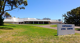
The Shire of Esperance is a local government area in the Goldfields-Esperance region of Western Australia, about 400 kilometres (250 mi) south of the town of Kalgoorlie and about 720 kilometres (450 mi) east-southeast of the state capital, Perth. The Shire covers an area of 42,547 square kilometres (16,427 sq mi), and its seat of government is the town of Esperance, where about three-quarters of the Shire's population resides.
Flaxley is a small settlement in the Adelaide Hills located 39 km south-east of the centre of the city of Adelaide in South Australia. It is situated in-between the larger towns of Echunga, Macclesfield and Meadows.
Biddaddaba is a rural locality in the Scenic Rim Region, Queensland, Australia. In the 2021 census, Biddaddaba had a population of 171 people.
Burpengary East is a coastal suburb in the City of Moreton Bay, Queensland, Australia. In the 2021 census, Burpengary East had a population of 9,654 people.
Telina is a suburb of Gladstone in the Gladstone Region, Queensland, Australia. In the 2021 census, Telina had a population of 2,197 people.
Germantown is a rural locality in the Cassowary Coast Region, Queensland, Australia. In the 2021 census, Germantown had a population of 52 people.
