
Mount Holyoke, a traprock mountain, elevation 935 feet (285 m), is the westernmost peak of the Holyoke Range and part of the 100-mile (160 km) Metacomet Ridge. The mountain is located in the Connecticut River Valley of western Massachusetts, and is the namesake of nearby Mount Holyoke College. The mountain is located in the towns of Hadley and South Hadley, Massachusetts. It is known for its historic summit house, auto road, scenic vistas, and biodiversity. The mountain is crossed by the 110-mile (180 km) Metacomet-Monadnock Trail and numerous shorter trails. Mount Holyoke is the home of J.A. Skinner State Park which is accessible from Route 47 in Hadley, Massachusetts.

Mount Monadnock, or Grand Monadnock, is a mountain in the towns of Jaffrey and Dublin, New Hampshire. It is the most prominent mountain peak in southern New Hampshire and is the highest point in Cheshire County. It lies 38 miles (61 km) southwest of Concord and 62 miles (100 km) northwest of Boston. At 3,165 feet (965 m), Mount Monadnock is nearly 1,000 feet (305 m) higher than any other mountain peak within 30 miles (48 km) and rises 2,000 feet (610 m) above the surrounding landscape. Monadnock's bare, isolated, and rocky summit provides expansive views. It is known for being featured in the writings of Ralph Waldo Emerson and Henry David Thoreau.
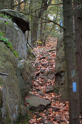
The Metacomet Trail is a 62.7-mile (100.9 km) Blue-Blazed hiking trail that traverses the Metacomet Ridge of central Connecticut and is a part of the newly designated New England National Scenic Trail. Despite being easily accessible and close to large population centers, the trail is considered remarkably rugged and scenic. The route includes many areas of unique ecologic, historic, and geologic interest. Notable features include waterfalls, dramatic cliff faces, woodlands, swamps, lakes, river flood plain, farmland, significant historic sites, and the summits of Talcott Mountain and the Hanging Hills. The Metacomet Trail is maintained largely through the efforts of the Connecticut Forest and Park Association.

Ragged Mountain, est. 761 feet (232 m), is a traprock mountain ridge located 3 miles (5 km) west of New Britain, Connecticut, in the towns of Southington and Berlin, Connecticut. It is part of the narrow, linear Metacomet Ridge that extends from Long Island Sound near New Haven, Connecticut, north through the Connecticut River Valley of Massachusetts to the Vermont border. The mountain, a popular hiking and rock climbing attraction located between metropolitan Hartford and Meriden, is known for expansive vistas, vertical cliff faces, mountain ridge reservoirs, unique microclimate ecosystems, and rare plant communities. Ragged Mountain is traversed by the 51-mile (82 km) Metacomet Trail.

The Metacomet-Monadnock Trail is a 114-mile-long (183 km) hiking trail that traverses the Metacomet Ridge of the Pioneer Valley region of Massachusetts and the central uplands of Massachusetts and southern New Hampshire. Although less than 70 miles (110 km) from Boston and other large population centers, the trail is considered remarkably rural and scenic and includes many areas of unique ecologic, historic, and geologic interest. Notable features include waterfalls, dramatic cliff faces, exposed mountain summits, woodlands, swamps, lakes, river floodplain, farmland, significant historic sites, and the summits of Mount Monadnock, Mount Tom and Mount Holyoke. The Metacomet-Monadnock Trail is maintained largely through the efforts of the Berkshire Chapter of the Appalachian Mountain Club (AMC). Much of the trail is a portion of the New England National Scenic Trail.

Bradley Mountain, 700 feet (210 m), is a traprock mountain located 3 miles (5 km) west of New Britain, Connecticut, United States, in the towns of Southington and Plainville. It is part of the narrow, linear Metacomet Ridge that extends from Long Island Sound near New Haven, Connecticut, north through the Connecticut River Valley of Massachusetts to the Vermont border. Bradley Mountain, popular as an outdoor recreation destination in the metropolitan Hartford/ New Britain area, is known for its clifftop scenic vistas overlooking Plainville Reservoir, unique microclimate ecosystems, and rare plant communities. Bradley Mountain is traversed by the 62.7-mile (101 km) Metacomet Trail.
Cathole Mountain, 515 feet (157 m), is the lowest peak in the trap rock Hanging Hills of Meriden, Connecticut. The rugged southern ledges of the mountain rise steeply 150 feet (46 m) above the city of Meriden. The mountain is separated from South Mountain by the narrow, rocky Cathole Pass through which Connecticut Route 71 ascends.

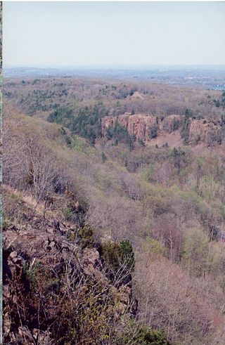
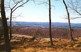
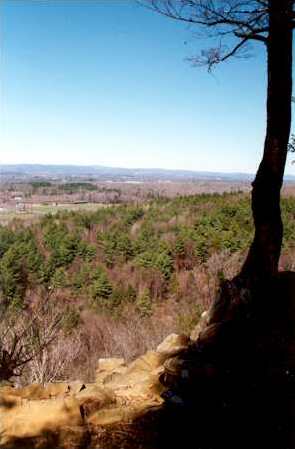
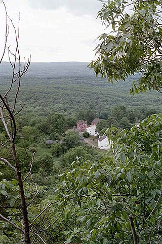
The Metacomet Ridge, Metacomet Ridge Mountains, or Metacomet Range of southern New England is a narrow and steep fault-block mountain ridge known for its extensive cliff faces, scenic vistas, microclimate ecosystems, and rare or endangered plants. The ridge is an important recreation resource located within 10 miles (16 km) of more than 1.5 million people, offering four long-distance hiking trails and over a dozen parks and recreation areas, including several historic sites. It has been the focus of ongoing conservation efforts because of its natural, historic, and recreational value, involving municipal, state, and national agencies and nearly two dozen non-profit organizations.
Provin Mountain is a very narrow traprock mountain ridge located in the Connecticut River Valley of Massachusetts. It is part of the Metacomet Ridge which extends from Long Island Sound near New Haven, Connecticut, north through the Connecticut River Valley of Massachusetts to the Vermont border. Provin Mountain is known for its scenic cliffs, unique microclimate ecosystems, and rare plant communities. It is traversed by the 114 mile (183 km) Metacomet-Monadnock Trail.

East Mountain is a traprock mountain ridge located in the Connecticut River Valley of Massachusetts. It is part of the narrow, linear Metacomet Ridge that extends from Long Island Sound near New Haven, Connecticut, north through the Connecticut River Valley of Massachusetts to the Vermont border. East Mountain is known for its extensive scenic cliffs, unique microclimate ecosystems, and rare plant communities. It is traversed by the 110-mile (180 km) Metacomet-Monadnock Trail.
West Suffield Mountain, est. 710 feet (220 m), is a traprock mountain ridge located between the Berkshires and the Connecticut River Valley in north-central Connecticut. It is part of the narrow, linear Metacomet Ridge that extends from Long Island Sound near New Haven, Connecticut, north through the Connecticut River Valley of Massachusetts to the Vermont border. West Suffield Mountain is known for its scenic ledges and woodlands, unique microclimate ecosystems, and rare plant communities. It is traversed by the 51-mile (82 km) Metacomet Trail, and the 110-mile (180 km) Metacomet-Monadnock Trail begins at the northern foot of West Suffield Mountain.
Short Mountain is a traprock mountain located in south central Connecticut 5 miles (8 km) north of the city of Meriden. It is part of the narrow Metacomet Ridge that extends from Long Island Sound near New Haven, Connecticut, north through the Connecticut River Valley of Massachusetts to the Vermont border. Short Mountain is known for its scenic cliffs, unique microclimate ecosystems, and rare plant communities. It is traversed by the 51-mile (82 km) Metacomet Trail.
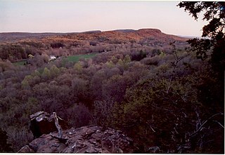
Peak Mountain, also called Copper Mountain, est. 730 feet (220 m), is a traprock mountain located in East Granby, Connecticut, 6 miles (10 km) south of the Massachusetts border and 6 miles west of the Connecticut River. It is part of the narrow, linear Metacomet Ridge that extends from Long Island Sound near New Haven, Connecticut, north through the Connecticut River Valley of Massachusetts to the Vermont border. Peak Mountain is known for its expansive views from 200 feet (61 m) high cliffs overlooking the historic Old Newgate Prison, Congamond Lake, and the Salmon Brook Valley of north-central Connecticut. The mountain is also known for its microclimate ecosystems, rare plant communities, and as a seasonal raptor migration path. It is traversed by the 51-mile (82 km) Metacomet Trail.

Hatchett Hill, est. 510 feet (160 m), is a trap rock ridge located in East Granby, Connecticut, 11 miles (18 km) northeast of Hartford, Connecticut. It is part of the narrow, linear Metacomet Ridge that extends from Long Island Sound near New Haven, Connecticut, north through the Connecticut River Valley of Massachusetts to the Vermont border. The southern edge of the ridge plunges nearly 200 vertical feet into the Tariffville Gorge. The ridge is known for its rugged topography, unique microclimate ecosystems, rare plant communities, and as a seasonal raptor migration path. It is traversed by the 51-mile (82 km) Metacomet Trail.
Rattlesnake Mountain is a traprock mountain, 750 feet (230 m) above sea level, located 9 miles (14 km) southwest of Hartford, Connecticut, in the town of Farmington. It is part of the narrow, linear Metacomet Ridge that extends from Long Island Sound near New Haven, Connecticut, north through the Connecticut River Valley of Massachusetts to the Vermont border. Rattlesnake Mountain, a popular outdoor recreation resource of the metropolitan Hartford area, is known for its cliff-top scenic vistas, unique microclimate ecosystems, and rare plant communities. Will Warren's Den, a boulder cave located on the mountain, is a local historic site. Rattlesnake Mountain is traversed by the 51-mile (82 km) Metacomet Trail.

Farmington Mountain, 502 feet (153 m), is a traprock ridge located 9 miles (14 km) southwest of Hartford, Connecticut, in the town of Farmington. It is part of the narrow, linear Metacomet Ridge that extends from Long Island Sound near New Haven, Connecticut, north through the Connecticut River Valley of Massachusetts to the Vermont border. Farmington Mountain is known for its microclimate ecosystems, rare plant communities, and for the historic Hill-Stead Museum. Farmington Mountain is traversed by the 51-mile (82 km) Metacomet Trail.
Higby Mountain or Mount Higby 892 feet (272 m), is a traprock mountain ridge located 3.75 miles (6.04 km) east of Meriden, Connecticut. It is part of the narrow, linear Metacomet Ridge that extends from Long Island Sound near New Haven, Connecticut, north through the Connecticut River Valley of Massachusetts to the Vermont border. Higby Mountain is known for its high cliff faces, unique microclimate ecosystems, and rare plant communities. It rises steeply 600 feet (180 m) above the Quinnipiac River valley and the city of Meriden to the west as a continuous 2-mile (3 km) long ledge. The mountain is traversed by the 50-mile (80 km) Mattabesett Trail.

Saltonstall Mountain, also known as Saltonstall Ridge, with a high point of (est.) 320 feet (98 m) above sea level, is a traprock mountain ridge located 3 miles (5 km) east of New Haven, Connecticut and 1.75 miles (2.8 km) north of Long Island Sound. It is part of the Metacomet Ridge that extends from Long Island Sound near New Haven, Connecticut, north through the Connecticut River Valley of Massachusetts to the Vermont border. Saltonstall Mountain is known for its 100 foot (30 m) scenic cliff faces and sharp ridgeline, unique microclimate ecosystems, rare plant communities, and for Lake Saltonstall, a 3 miles (5 km) long by 0.3 miles (400 m) wide municipal reservoir nearly enclosed by the mountain. Saltonstall Mountain is traversed by a number of hiking trails managed by the South Central Connecticut Regional Water Authority (SCCRWA) and Branford Land Trust.

The Tunxis Trail is a 79-mile (127 km) Blue-Blazed hiking trail "system" that traverses the western ridge of the central Connecticut Valley. The mainline trail is not completely contiguous, notably there are two gaps of several miles.