Narragansett Trail

Last updated

Narragansett Trail
Narragansett Trail "white oval" sign on CT Route 2 near Gallup Pond and Ryder Road..jpg
Narragansett Trail "white oval" sign at junction of Connecticut State Route 2 and Ryder Road.
Length16 miles (26 km) [1]
Location Connecticut
DesignationCFPA Blue-Blazed Trail
Use Hiking, running, cross-country skiing, snowshoeing
Highest point Lantern Hill
41°27′39″N71°56′39″W / 41.4608°N 71.9441°W / 41.4608; -71.9441 , 490 ft (150 m)
Lowest point Lantern Hill Pond, 115 ft (35 m)
Sights Lantern Hill, High Ledge, Wyassup Lake, Green Falls Pond, CT/RI Border Marker
Hazards Hunters, deer ticks, poison ivy, insects, snakes, black bears

The Narragansett Trail is a 16-mile (26 km) hiking trail located in Connecticut. It is one of the Blue-Blazed Trails maintained by the Connecticut Forest and Park Association, the Narragansett Council, and The Rhode Island chapter of Scouts BSA.

Contents

The trail passes through the towns of Ledyard, Voluntown, and North Stonington in eastern Connecticut and runs along the Connecticut/Rhode Island border. It traverses the Lantern Hill section of the Mashantucket Pequot Reservation, the Groton Sportsman Club, the Nature Conservancy's Gladys Foster Preserve, the Pachaug State Forest Green Falls Pond area, and the Rhode Island Scouts BSA Narragansett Council Camp Yawgoog reservation property.

For 15.5 miles, the Narragansett Trail follows a primarily southwest-to-northeast trail. However, at the easternmost end, the trail becomes a north-to-south trail section that strictly follows the Connecticut/Rhode Island border south for 0.5 miles. Notable features include the summits of Lantern Hill and High Ledge. The trail also goes near, but does not summit, Cossaduck Hill and Pendleton Hill. [2]

Trail description

The Narragansett Trail is a Blue-Blazed Hiking Trail and extends from Wintechog Road near the intersection with Connecticut Route 2 in Ledyard, Connecticut, to Green Fall Road in North Stonington at the Connecticut / Rhode Island state line. Much of the Narragansett Trail is on state land within the Pachaug State Forest. The Narragansett Trail connects to public recreation areas maintained by the Connecticut Department of Environmental Protection at Green Falls Pond and Wyassup Lake in Pachaug State Forest.

Much of the Narragansett Trail is flat or has gradual ascents and descents, and is suitable for casual walking or hiking, running - or snowshoeing in the winter. The trail has the highest uphill grade when it crosses a closed section of Flat Rock Road. The Narragansett Trail crosses streams and wetland areas that are subject to flooding in periods of significant rain and snow melt. Trail sections in low-lying areas close to Hell Hollow Pond and Lockes Meadow Pond are the most frequently flooded.

The trail connects to two other Blue-Blazed Hiking Trails via the Green Falls Pond Loop connector trail: the Nehantic Trail and Pachaug Trail in Connecticut's Pachaug State Forest. The Green Falls Pond Loop trail and Narragansett Trail overlap around the southern and eastern shores of Green Falls Pond.

The Narragansett Trail connects to several other trails outside the "Blue-Blazed" system, including sections of the Lantern Hill trail in the west and several unnamed trails along its route. The Tippecansett Trail connects to the Narragansett Trail at the Connecticut/Rhode Island state border.

Trail route

Narragansett Trail blazes with Lantern Hill and Loop Trail signs. Narragansett Trail blazes with Lantern Hill and Loop Trail signs.jpg
Narragansett Trail blazes with Lantern Hill and Loop Trail signs.

The western end of the Narragansett Trail starts on Wintechog Road in North Stonington, Connecticut, to the southeast of the Mashantucket Pequot Tribe's Foxwoods Casino in Ledyard, Connecticut. The trail climbs southward, connecting with the Lantern Hill trail and Lantern Hill Loop trail. After climbing to the Lantern Hill summit the trail descends to the west and heads north-west. It passes through the North Stonington dog pound and waste transfer station property before crossing Wintechog Road. The trail continues north through woods and eventually passes through two open fields. After the Gallup Pond dam bridge the trail crosses Connecticut Route 2. There is a short road walk to and down Ryder Road to the trail entrance at the Nature Conservancy's Gladys Foster parcel. The trail continues to Yawbux Brook and an unnamed beaver pond before entering Pachaug State Forest. The trail then joins Wyassup Lake Road at the Lake Wyassup boat launch. From the Lake Wyassup boat launch, the trail climbs to the High Ledge plateau and then to the Legend Woods / Pendleton Hill area before crossing Connecticut Route 49.

Next, the trail travels north-east through the private hunting preserve (and fishing pond) of the Groton Sportsmen Club (this Narragansett Trail section is closed from October to March according to posted signs), re-enters the Pachaug State Forest at Tom Wheeler Road and follows the Green Fall River (and ravine) north to Green Fall Pond. The trail follows the southeast shore of the pond before leaving the shore of the pond to head east to the Rhode Island border. At the border, the trail turns ninety degrees to head south over a rock ridge housing a cave. After a half mile, the trail's Connecticut section ends at a small parking lot and state line marker where Green Fall Road becomes Yawgoog Road in Rhode Island.

There is a four-mile extension of the trail into Rhode Island which is blazed yellow. This Narragansett Trail extension passes by the Long and Ell Ponds and through the Rockville Wildlife Management Area before ending at Ashville Pond in Hopkinton, Rhode Island. The Narragansett Trail used to continue to Rhode Island Route 138 in Kingston, Rhode Island.

Trail communities

The Narragansett Trail passes through land located within the following Connecticut municipalities, from west to east: Ledyard, Voluntown,

and North Stonington

Landscape, geology, and natural environment

The landscape in the area is generally low-lying and flat with some rolling hills. The most prominent features are Lantern Hill and the High Ledge plateau and rocks (containing some small caves).

In terms of animal wildlife numerous vultures and ravens can be spotted flying around the summit of Lantern Hill and black bear sightings have been reported in the Pachaug State Forest area near the state border.

The Pachaug State Forest Green Falls Pond area features large extents of undeveloped land, consisting of mature growths of hardwood and evergreens, along with swampy areas having extensive coverage by Mountain Laurel, Rhododendron, and other shrubs and smaller trees.

The Narragansett Council (Rhode Island Boy Scouts of America chapter) property at the eastern end of the trail is similar to the Pachaug State Forest terrain. In addition, the several swampy areas breed many biting insects including large horse-flies in season.

History and folklore

Narragansett Trail Eastern Terminus - Connecticut - Rhode Island State Line Marker on Green Fall Road. Narragansett Trail Eastern Terminus - Connecticut - Rhode Island State Line Marker on Green Fall Road.jpg
Narragansett Trail Eastern Terminus - Connecticut - Rhode Island State Line Marker on Green Fall Road.

The Blue-Blazed Narragansett Trail was created by the Connecticut Forest and Park Association as part of the Blue-Blazed Hiking Trail system. The eastern end of the longer Pequot Trail blazed in the 1930s connected to the western end of the Narragansett Trail at the Lantern Hill section of the Mashantucket Pequot reservation. The original "connection" of these two trails can be seen in the Connecticut Forest and Park Association 1940 Connecticut Walk Book map of major trails. [3] The missing "gap" sections are on Mashantucket Pequot Tribal Nation property and are trails used for centuries by the Pequot tribe. [4] Plans are underway to lengthen the Pequot Trail and return the south-eastern terminus to its original location with the Narragansett Trail on Lantern Hill in North Stonington via the Mashantucket Pequot Tribal Nation property near their museum and research center.

Origin and name

The original Blue-Blazed Hiking Trails were named after Native American people and place names, in recognition that many of the trails followed historic footpaths. Trails added since often follow this convention, so many of the trails have Native American names.

The Narragansett is a tribe of Algonquian-speaking people who live in the area which is now western Rhode Island including the coast and islands in Narragansett Bay. Members of the recognized tribe continue to live in areas of eastern Connecticut near the current border with Rhode Island.

The word "Narragansett" means, "People of the Small Point." [5] See Narragansett name and language.

Historic sites

The foundations for stone cellars that can be found along the route indicate that much of the landscape was used for settlements and farms up until the late nineteenth and early twentieth century, after which much of the land was allowed to return to forests. In particular stone foundations and extensive stone walls can be found off of the trail east of High Ledge in the Legend Woods area.

Pachaug State Forest was the first state forest in Connecticut and grew quickly in acreage primarily because many of the farmers and landholders in the area realized that their soil was poor for farming and sold their land to the state in the 1920s and 1930s.

Folklore

The town name of Voluntown is attributed to the fact that it was settled by Volunteers of the Narragansett War in 1700 who received land grants to settle there. The land was remote and difficult to farm and many of the original settlements were subsequently abandoned, so stone walls and foundations can be found throughout the forest today.[ citation needed ]

Hiking the trail

Narragansett Trail's south-west trailhead at Wintechog Road. Narragansett Trail's south-east trail head on Wintechog Road.jpg
Narragansett Trail's south-west trailhead at Wintechog Road.

The mainline trail is directed with blue rectangles. Trail descriptions are available from several commercial and non-commercial sources, and a complete guidebook is published by the Connecticut Forest and Park Association. More information can be found on the CFPA website (http://ctwoodlands.org/blue-blazed-hiking-trails) including updates on trail conditions and closure or restrictions. Contact information is also available on the site for trail users to report adverse trail conditions or submit other feedback or questions.

Weather along the route is typical of Connecticut. Conditions on exposed ridge tops and summits may be harsher during cold or stormy weather. [6] Lightning is a hazard on exposed summits and ledges during thunderstorms. Snow and ice formations along exposed ledges and summits are common in the winter and may necessitate the use of snowshoes and special equipment.

The landscape is low-lying and trails cross wetland areas. Extensive rain and snow melt can lead to wet and muddy conditions, and in this case, fairly high waterproof boots are recommended.

Currently, hiking through the property owned by Groton Rod and Gun Club is prohibited. The trail that runs between Route 49 and Tom Wheeler Rd, (Groton Rod and Gun property) can be avoided by walking Pendleton Hill Road to Sand Hill Road to Tom Wheeler Road and rejoining the trail on Tom Wheeler Road.

Biting insects such as parasitic deer ticks (which are known to carry Lyme disease) are a potential hazard as well as encounters with small wildlife. Knowing the signs of erratic behavior or other disease symptoms and taking evasive action if warranted.

Seasonal hunting is permitted on state forest land, so wearing bright orange clothing during the hunting season (Fall through December) is advised.

State regulations govern the use of state forest land. The land, plants, and animals should generally be left undisturbed, especially endangered and protected species. For guidelines on how to act during a black bear encounter please view the American Bear Association hiking and camping awareness page.

Conservation and maintenance of the trail corridor

Much of the trail is flooded or muddy. There are sections filled with stones and other evidence of erosion that has occurred when the trail has turned into a temporary stream.

There is also evidence of use by all-terrain vehicles (ATVs), dirt bikes, and horses. Some sections of the Narragansett trail are explicitly multi-use (paved roads, dirt/gravel forest roads, jeep trails, and the Enduro off-road motorcycle trail which winds through Pachaug State Forest); but in other sections, there is unauthorized vehicular and equestrian use.

The 58-mile Enduro trail in Pachaug State Forest is marked (on turns and intersections on trees) with white labels containing a red arrow pointing in the trail's direction. The route follows a mix of forest trails and public roads. This combination requires both a valid current motorcycle registration and motorcycle driver's license rather than ATV registration.

Recognition/inspiration programs

There is a State of Connecticut Department of Environmental Protection letterbox hidden close to the trail on the High Ledge plateau. [7]

See also

Bibliography

Heermance, Edgar L. (1935). The Connecticut Guide: What to See and Where to Find It. Hartford: Emergency Relief Commission. pp.  246–247. OCLC   719786.

Haynes, Williams; Boylan, James (1976). Stonington Historical Society (ed.). Stonington Chronology 1649-1976: Being a year-by-year record of the American way of life in a Connecticut town (2nd ed.). Chester Connecticut: Pequot Press. p. 74. ISBN   0-87106-059-0. OCLC   2523265.

Philips, David E. (1992). Legendary Connecticut: Traditional Tales from the Nutmeg State (2nd ed.). Willimantic: Curbstone. pp.  122. ISBN   1-880684-05-5. OCLC   26218340.

Pritzker, Barry M. (2000). A Native American Encyclopedia: History, Culture, and Peoples . Oxford: Oxford University Press. ISBN   978-0-19-513877-1.

Related Research Articles

<span class="mw-page-title-main">Pequots</span> Indigenous people from Connecticut, US

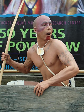
The Pequot are a Native American people of Connecticut. The modern Pequot are members of the federally recognized Mashantucket Pequot Tribe, four other state-recognized groups in Connecticut including the Eastern Pequot Tribal Nation, or the Brothertown Indians of Wisconsin. They historically spoke Pequot, a dialect of the Mohegan-Pequot language, which became extinct by the early 20th century. Some tribal members are undertaking revival efforts.

<span class="mw-page-title-main">Mashantucket Pequot Tribe</span> American Indian tribe in the state of Connecticut

The Mashantucket Pequot Tribal Nation is a federally recognized American Indian tribe in the state of Connecticut. They are descended from the Pequot people, an Algonquian-language tribe that dominated the southern New England coastal areas, and they own and operate Foxwoods Resort Casino within their reservation in Ledyard, Connecticut. As of 2018, Foxwoods Resort Casino is one of the largest casinos in the world in terms of square footage, casino floor size, and number of slot machines, and it was one of the most economically successful in the United States until 2007, but it became deeply in debt by 2012 due to its expansion and changing conditions.

<span class="mw-page-title-main">New London County, Connecticut</span> County in Connecticut, United States

New London County is in the southeastern corner of Connecticut and comprises the Norwich-New London, Connecticut Metropolitan Statistical Area, which is also included in the Hartford-East Hartford, Connecticut Combined Statistical Area. There is no county government and no county seat, as is the case with all eight of Connecticut's counties; towns are responsible for all local government activities, including fire and rescue, snow removal, and schools.

<span class="mw-page-title-main">North Stonington, Connecticut</span> Town in Connecticut, United States

North Stonington is a town in New London County, Connecticut which was split off from Stonington in 1724. The town is part of the Southeastern Connecticut Planning Region. The population was 5,149 at the 2020 census.

<span class="mw-page-title-main">Pachaug State Forest</span> Large American forested area

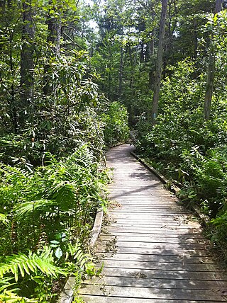
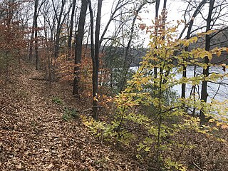
Pachaug State Forest is the largest forest in the Connecticut state forest system, encompassing over 27,000 acres (110 km²) of land. It is located on the Rhode Island border in New London County, and parcels of the forest lie in the towns of Voluntown, Griswold, Plainfield, Sterling, North Stonington, and Preston. The forest was founded in 1928, but most of the land came from purchases made later during the Great Depression. It is named after the Pachaug River, which runs through the center of the forest. The forest is part of the Northeastern coastal forests ecoregion.

<span class="mw-page-title-main">Lantern Hill</span>

Lantern Hill, elevation 491 feet, is a hill located in North Stonington, New London County, Connecticut.

<span class="mw-page-title-main">Mattabesett Trail</span>

The Mattabesett Trail is a 62-mile (100 km) long, hook-shaped blue-blazed hiking trail in central Connecticut and a part of the New England National Scenic Trail. One half of the trail follows the high traprock ridges of the Metacomet Ridge, from Totoket Mountain in Guilford, Connecticut, to Lamentation Mountain in Meriden, Connecticut, from south to north. This ridge is known for its biodiversity, miles of scenic cliffs, and rugged hiking. The second half of the trail extends north from Guilford to Middletown, Connecticut, and ends at the Connecticut River. Here, the trail follows an upland of metamorphic rock with occasional views and dense forests.

<span class="mw-page-title-main">Blue-Blazed Trails</span> US hiking trails

The Blue-Blazed Hiking Trail (BBHT) system, managed by the Connecticut Forest & Park Association (CFPA), and the related trail systems documented in the two-volume 19th Edition of the "Connecticut Walk Book" comprise over 800 miles of hiking trails in Connecticut.

<span class="mw-page-title-main">Tunxis Trail</span>

The Tunxis Trail is a 79-mile (127 km) Blue-Blazed hiking trail "system" that traverses the western ridge of the central Connecticut Valley. The mainline trail is not completely contiguous, notably there are two gaps of several miles.

<span class="mw-page-title-main">Naugatuck Trail</span>

The Naugatuck Trail is a 6.8-mile (10.9 km) Blue-Blazed hiking trail "system" in the eastern central-lower Naugatuck River Valley in New Haven County, Connecticut, USA. It is almost entirely contained in the Naugatuck State Forest. The mainline trail is primarily east to west with three short side or spur trails. Composed of four trails, at its western end the trail ends with a section alongside Route 8 and the Naugatuck River. During the 1930s and 1940s, it was much larger. But post–World War II housing developments of the Connecticut Blue-Blazed Trails, led to its drastic reduction.

<span class="mw-page-title-main">Paugussett Trail</span>

The Paugussett Trail is a 14-mile (23 km) Blue-Blazed hiking trail "system" in the lower Housatonic River valley in Fairfield County and, today, is entirely in Shelton and Monroe, Connecticut. Much of the trail is in Indian Well State Park and the Town of Monroe's Webb Mountain Park. The mainline trail is primarily southeast to northwest with three short side or spur trails.

<span class="mw-page-title-main">Lillinonah Trail</span>

The Lillinonah Trail is a 5.9-mile (9.5 km) Blue-Blazed hiking trail "system" in the lower Housatonic River valley in Fairfield County and, today, is entirely in Newtown. Most of the trail is in the upper block of Paugussett State Forest.

<span class="mw-page-title-main">Aspetuck Valley Trail</span>

The Aspetuck Valley Trail is a 5.9-mile (9.5 km) Blue-Blazed hiking trail in the Aspetuck River Valley area of Fairfield County in the towns of Newtown, Easton and Redding Connecticut.

<span class="mw-page-title-main">Zoar Trail</span>

The Zoar Trail is a 6.5-mile (10.5 km) Blue-Blazed hiking trail "system" in the lower Housatonic River valley in Fairfield County and is entirely in the Sandy Hook section of Newtown in the lower block of Paugussett State Forest.

<span class="mw-page-title-main">Pomperaug Trail</span>

The Kettletown Trails are a 4.6-mile (7.4 km) Blue-Blazed hiking trail "system" in the lower Housatonic River valley in Fairfield County and are in the towns of Southbury and Oxford -- primarily in the Kettletown State Park and the Jackson Cove recreation area belonging to the town of Oxford.

<span class="mw-page-title-main">Nehantic Trail</span>

The Nehantic Trail is a 13-mile (21 km) Connecticut hiking trail and is one of the Blue-Blazed hiking trails maintained by the Connecticut Forest and Park Association.

<span class="mw-page-title-main">Natchaug Trail</span> Hiking trail

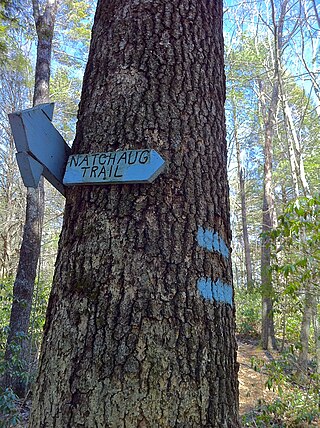
The Natchaug Trail is a Blue-Blazed hiking trail "system" which meanders through 19.5 miles (31.4 km) of forests in northeast Connecticut—primarily in Windham County. It is maintained by the Connecticut Forest and Park Association. Its southern trailhead begins in the James L. Goodwin State Forest in the towns of Chaplin, Connecticut and Hampton, Connecticut and the northern terminus is at its intersection with the Nipmuck Trail in Natchaug State Forest in Eastford, Connecticut.

<span class="mw-page-title-main">Quinebaug Trail</span>

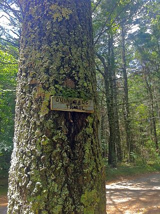
The Quinebaug Trail is a 8.1-mile (13.0 km) Connecticut hiking trail and is one of the Blue-Blazed hiking trails maintained by the Connecticut Forest and Park Association.

<span class="mw-page-title-main">Pachaug Trail</span>

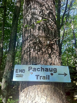
The Pachaug Trail is a 28-mile (45 km) Connecticut hiking trail and is one of the Blue-Blazed hiking trails maintained by the Connecticut Forest and Park Association. It is a horseshoe shaped trail.

<span class="mw-page-title-main">Pequot Trail</span> Hiking trail in Connecticut, US

The Pequot Trail is a 7.6-mile (12.2 km) Blue-Blazed Trail, a hiking trail maintained by the Connecticut Forest and Park Association.

References

  1. Colson, Ann T. (2006). Connecticut Walk Book West (19th ed.). Connecticut Forest and Park Association. ISBN   0-9619052-6-3.
  2. Connecticut Walk Book: A Trail Guide to the Connecticut Outdoors. 17th Edition. The Connecticut Forest and Park Association. Rockfall, Connecticut. Undated.
  3. "Archived copy". Archived from the original on July 8, 2011. Retrieved August 2, 2011.{{cite web}}: CS1 maint: archived copy as title (link)
  4. "The Mashantucket (Western) Pequot Tribal Nation". www.mptn-nsn.gov. Retrieved August 10, 2023.
  5. Pritzker, 442
  6. NOAA
  7. Connecticut State Forests - Seedling Letterbox Series Clues for Pachaug State Forest

Further reading

Books – Connecticut hiking[ edit ]

Books – Connecticut history and geography[ edit ]

Trail Maps:

Specific to this trail:

Nearby areas and the Pachaug State Forest:

Connecticut hikes and related information: