Mansfield Hollow State Park

Last updated
Mansfield Hollow State Park
USACE Mansfield Hollow Lake.jpg
Relief map USA Connecticut.png
Red pog.svg
Location in Connecticut
Location Mansfield, Connecticut, United States
Coordinates 41°46′06″N72°10′32″W / 41.76833°N 72.17556°W / 41.76833; -72.17556 Coordinates: 41°46′06″N72°10′32″W / 41.76833°N 72.17556°W / 41.76833; -72.17556
(boat ramp)
Area251 acres (102 ha) [1]
Elevation210 ft (64 m) [2]
Designation Connecticut state park
Established1952 [3]
Administrator Connecticut Department of Energy and Environmental Protection
Website Mansfield Hollow State Park

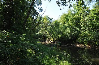
Mansfield Hollow State Park is a public recreation area occupying 251 acres (102 ha) of leased lands on the western shore of 500-acre (200 ha) Mansfield Hollow Lake in the town of Mansfield, Connecticut. [3] The state park is one portion of the 2,300 acres (930 ha) leased by the Connecticut Department of Energy and Environmental Protection from the U.S. Army Corps of Engineers for recreational and wildlife management purposes. [4] Geologic features of the park include remnants of the last glacial period, where retreating glaciers left kames, eskers, and kettles. [5] Recreational opportunities include facilities for boating, fishing, picnicking, hiking, mountain biking, and cross-country skiing. [3] The park is traversed by the southeastern leg of the Nipmuck Trail.

Mansfield Hollow Lake lake of the United States of America

Mansfield Hollow Lake is a reservoir resting on the border of Windham County and Tolland County, Connecticut. The reservoir provides drinking water for Willimantic and helps control flooding in the 159-square-mile Thames River watershed. It was created by the Mansfield Hollow Dam and is entirely contained within Mansfield Hollow State Park and the Mansfield Hollow Wildlife Area. Designed and constructed by the United States Army Corps of Engineers, the dam substantially reduces flooding along the Quinebaug, Shetucket, and Thames rivers. Construction of the project began in 1949 with completion in 1952 at a cost of US$6.5 million. The Mansfield Hollow reservoir is located within the Shetucket River Watershed and is part of the Thames River Basin. Access to the site is available from US Route 6 and State Route 195. The damsite, covering an area of 25 acres (10 ha), was listed on the National Register of Historic Places in 2003.

New England town Basic unit of local government in each of the six New England federated states of the United States

The New England town, generally referred to simply as a town in New England, is the basic unit of local government and local division of state authority in each of the six New England states and without a direct counterpart in most other U.S. states. New England towns overlay the entire area of a state, similar to civil townships in other states where they exist, but they are fully functioning municipal corporations, possessing powers similar to cities in other states. New Jersey's system of equally powerful townships, boroughs, towns, and cities is the system which is most similar to that of New England. New England towns are often governed by a town meeting legislative body. The great majority of municipal corporations in New England are based on the town model; statutory forms based on the concept of a compact populated place are uncommon, though they are prevalent elsewhere in the U.S. County government in New England states is typically weak at best, and in some states nonexistent. Connecticut, for example, has no county governments, nor does Rhode Island. Both of those states retain counties only as geographic subdivisions with no governmental authority, while Massachusetts has abolished eight of fourteen county governments so far. With few exceptions, counties serve mostly as dividing lines for the states' judicial systems.

Mansfield, Connecticut Town in Connecticut, United States

Mansfield is a town in Tolland County, Connecticut, United States. The population was 26,543 at the 2010 census.

Related Research Articles

Chatfield Hollow State Park

Chatfield Hollow State Park is a public recreation area occupying 412 acres (167 ha) that lie adjacent to Cockaponset State Forest in the town of Killingworth, Connecticut. The state park offers hiking trails, a swimming beach, trout fishing, mountain biking, rock climbing, and picnicking areas. Park attractions include 6.67-acre (2.70 ha) Schreeder Pond, Indian caves, historic sites, a restored water wheel, and a reproduction covered bridge. The park is managed by the Connecticut Department of Energy and Environmental Protection.

Douglas State Forest

Douglas State Forest is a publicly owned forest with recreational features that borders both Connecticut and Rhode Island, located in the town of Douglas, Massachusetts. The state forest's 5,525 acres (2,236 ha) include Wallum Lake and a rare Atlantic white cedar swamp, 5 acres (2.0 ha) of which are designated as a Massachusetts Wildland. The forest is managed by the Massachusetts Department of Conservation and Recreation.

Lake Dennison Recreation Area

Lake Dennison Recreation Area is a 121-acre (49 ha) Massachusetts state park located in the town of Winchendon. It comprises a small portion of the 4,221 acres (1,708 ha) of the U.S. Army Corps of Engineers' Birch Hill Flood Control Project that are managed by the Department of Conservation and Recreation and that also include Otter River State Forest.

Bigelow Hollow State Park

Bigelow Hollow State Park is public recreation area in the town of Union, Connecticut, in the Quinebaug Highlands. The state park's 516 acres (209 ha) border Nipmuck State Forest on the east and west and Mashapaug Lake on the north. The park and forest are located in a large hollow or depression approximately 700' below the surrounding ridgelines. They are managed by the Connecticut Department of Energy and Environmental Protection.

Indian Well State Park

Indian Well State Park is a public recreation area occupying 153 acres (62 ha) on the west bank of Lake Housatonic, an impoundment of the Housatonic River, within the city limits of Shelton, Connecticut. The state park's scenic features include a 15-foot (4.6 m) horsetail waterfalls with splash pool at bottom. The park is managed by the Connecticut Department of Energy and Environmental Protection.

Nipmuck State Forest

Nipmuck State Forest is a Connecticut state forest. Its 9,000 acres (3,600 ha) surround Bigelow Hollow State Park in the town of Union and include parcels in Stafford, Ashford, and other towns. The forest is part of a larger network of forest lands making up some 40,000 acres (16,000 ha) in all.

Scantic River State Park

Scantic River State Park is a public recreation area consisting of several separated parcels totaling 784 acres (317 ha) along the Scantic River in the towns of Enfield, East Windsor, and Somers, Connecticut. The state park is suitable for hiking, fishing, and hunting and is managed by the Connecticut Department of Energy and Environmental Protection.

Killingly Pond State Park

Killingly Pond State Park is a public recreation area encompassing 162 acres (66 ha) in the town of Killingly, Connecticut. The state park sits on the western side of Killingly Pond, a 122-acre (49 ha) body of water that straddles the state line between Connecticut and Rhode Island. The park offers boating, fishing, hiking, and hunting.

Quinebaug Lake State Park

Quinebaug Lake State Park is a public recreation area covering 181 acres (73 ha) in the town of Killingly, Connecticut. The state park offers opportunities for fishing and non-motorized boating on Wauregan Reservoir. The park is managed by the Connecticut Department of Energy and Environmental Protection.

Camp Columbia State Park/State Forest

Camp Columbia State Park/State Forest is a public recreation area and state forest located in the town of Morris in Litchfield County, Connecticut. The 600-acre (240 ha) site was once the rural campus of Columbia University's Engineering Department. The majority of the property has been designated as a state forest; the acreage designated as a state historic park includes the frontage on Bantam Lake and the site of the former university buildings. It is managed by the Connecticut Department of Energy and Environmental Protection.

John A. Minetto State Park

John A. Minetto State Park is a public recreation area encompassing 715 acres (289 ha) in the towns of Goshen and Torrington, Connecticut. Facilities are available for picnicking, fishing, and cross-country skiing. The state park is managed by the Connecticut Department of Energy and Environmental Protection.

Hopeville Pond State Park

Hopeville Pond State Park is a public recreation area located on Hopeville Pond, an impoundment of the Pachaug River, in the town of Griswold, Connecticut. A portion of the 554-acre (224 ha) state park occupies the site of the lost village of Hopeville. The park manager's house occupies Avery House, which is listed on the National Register of Historic Places. The park offers fishing, swimming, camping, and trails for hiking and biking. It is managed by the Connecticut Department of Energy and Environmental Protection.

Mooween State Park

Mooween State Park is a public recreation area covering 577 acres (234 ha) in the town of Lebanon, Connecticut. The state park offers hiking and mountain biking plus fishing and boating on 127-acre (51 ha) Red Cedar Lake.

Becket Hill State Park Reserve

Becket Hill State Park Reserve is a public recreation area lying adjacent to Nehantic State Forest in the town of Lyme, Connecticut. The state park is as an undeveloped, walk-in park totaling 260 acres (110 ha) with no officially listed activities. It is managed by the Connecticut Department of Energy and Environmental Protection.

James L. Goodwin State Forest

James L. Goodwin State Forest is a Connecticut state forest covering approximately 2,000 acres (810 ha) in the towns of Chaplin and Hampton. The lands became public property when James L. Goodwin donated the personal forest he had been developing since 1913 to the state in 1964.

Nathan Hale State Forest

Nathan Hale State Forest is a Connecticut state forest encompassing 1,455 acres (589 ha) in the towns of Coventry and Andover. The forest is managed to sustain a reliable source of forest products and renewable habitat for wildlife. The forest originated in 1946 through the bequest of George Dudley Seymour, which allowed the state to purchase 850 acres in the surrounds of the historic Nathan Hale Homestead. In addition to cultivated plantations, the forest includes a 200-acre natural area that is kept without management activity. A 57-acre (23 ha) parcel, Creaser Park, is leased to the Town of Coventry for recreational use. The park offers hiking trails, fishing, and a dog-friendly area. Recreational usage in the rest of the forest includes hiking, hunting and letterboxing.

West Thompson Lake

West Thompson Lake is a 200-acre lake in Thompson, Windham County, Connecticut.

Peoples State Forest

Peoples State Forest is a Connecticut state forest occupying 3,059 acres (1,238 ha) along the West Branch Farmington River opposite American Legion State Forest in the town of Barkhamsted. It is managed for forest products, wildlife habitat, and recreational uses that include hiking, hunting, fishing, and snowmobiling.

Nassahegon State Forest

Nassahegon State Forest is a Connecticut state forest occupying 1,227 acres (497 ha) in the town of Burlington.The forest is managed for forestry and recreational purposes and is operated by the Connecticut Department of Energy and Environmental Protection.

References

  1. "Appendix A: List of State Parks and Forests" (PDF). State Parks and Forests: Funding. Staff Findings and Recommendations. Connecticut General Assembly. January 23, 2014. p. A-2. Retrieved March 20, 2014.
  2. "Mansfield Hollow Dam". Geographic Names Information System . United States Geological Survey.
  3. 1 2 3 "Mansfield Hollow State Park". State Parks and Forests. Connecticut Department of Energy and Environmental Protection. August 15, 2017. Retrieved October 2, 2017.
  4. "Mansfield Hollow Lake". U.S. Army Corps of Engineers. June 11, 2015. Retrieved October 2, 2017.
  5. "Geology of Mansfield Hollow State Park". State Parks and Forests. Connecticut Department of Energy and Environmental Protection. Retrieved February 5, 2013.