Chatfield Hollow State Park is a public recreation area occupying 412 acres (167 ha) that lie adjacent to Cockaponset State Forest in the town of Killingworth, Connecticut. The state park offers hiking trails, a swimming beach, trout fishing, mountain biking, rock climbing, and picnicking areas. Park attractions include 6.67-acre (2.70 ha) Schreeder Pond, Indian caves, historic sites, a restored water wheel, and a reproduction covered bridge. The park is managed by the Connecticut Department of Energy and Environmental Protection.

Air Line State Park Trail is a rail trail and linear state park located in Connecticut. The trail is divided into sections designated South, North a piece of the East Coast Greenway, and the Thompson addition. An additional 3.6-mile spur to Colchester is sometimes designated as part of the Air Line trail. At the Massachusetts state line, the trail connects to the Southern New England Trunkline Trail, a 22-mile-long trail to Franklin, MA built on the same right-of-way. Since 2018, the town of Portland, Connecticut has also maintained a 2.3-mile portion of the Air Line trail, connecting to the southern end of the state park at the town line with East Hampton.

Hop River State Park Trail is a Connecticut rail trail that winds for 20.8 miles (33.5 km) eastward from Colonial Drive in the town of Manchester to the Air Line State Park Trail S. in the town of Windham. The trail parallels the Hop River for much of its length. It is owned and operated by the Connecticut Department of Energy and Environmental Protection, with upgrades and maintenance done by town forces and community volunteer groups in coordination with the state. The trail is used for hiking, biking, horseback riding, and cross-country skiing.

Mansfield Hollow Lake is a reservoir resting on the border of Windham County and Tolland County, Connecticut. The reservoir provides drinking water for Willimantic and helps control flooding in the 159-square-mile Thames River watershed. It was created by the Mansfield Hollow Dam and is entirely contained within Mansfield Hollow State Park and the Mansfield Hollow Wildlife Area. Designed and constructed by the United States Army Corps of Engineers, the dam substantially reduces flooding along the Quinebaug, Shetucket, and Thames rivers. Construction of the project began in 1949 with completion in 1952 at a cost of US$6.5 million. The Mansfield Hollow reservoir is located within the Shetucket River Watershed and is part of the Thames River Basin. Access to the site is available from US Route 6 and State Route 195. The damsite, covering an area of 25 acres (10 ha), was listed on the National Register of Historic Places in 2003.

Beaver Brook State Park is an undeveloped public recreation area covering 401 acres (162 ha) in the towns of Windham and Chaplin, Connecticut. The state park encompasses Bibbins Pond, also known as Beaver Brook Pond, as well as the acreage northward as far as the Air Line State Park Trail, which forms the park's northern boundary. The park is a walk-in facility, open for hunting and trout fishing, managed by the Connecticut Department of Energy and Environmental Protection.
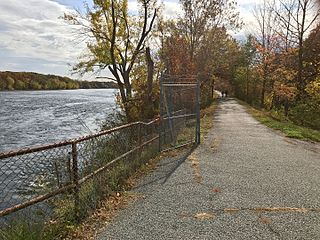
Windsor Locks Canal State Park Trail is a public recreation area that parallels the Connecticut River for 4.5 miles (7.2 km) between Suffield and Windsor Locks, Connecticut. The modern paved surface covers the original dirt towpath of the historic Enfield Falls Canal. The park is used for fishing, hiking, and biking.

Satan's Kingdom State Recreation Area is a public recreation area occupying one acre (0.40 ha) of land beside the Farmington River in the town of New Hartford, Connecticut. The site is located on the north side of the Route 44 bridge over the Farmington River. It is used as a put-in for canoeing, kayaking, and tubing excursions on the river.

Sunnybrook State Park is a public recreation area encompassing 464 acres (188 ha) in the town of Torrington, Connecticut. The state park is the southwestern terminus for the blue-blazed John Muir Trail which crosses Paugnut State Forest for two miles to the loop trail at Burr Pond State Park. Another park trail bears the name of former property owner Edwin Fadoir. In addition to hiking, the park offers picnicking, hunting, and fishing along the East Branch Naugatuck River. The park opened in 1970 and entered the state rolls in the 1971 edition of the Connecticut Register and Manual.

Wooster Mountain State Park is an undeveloped public recreation area located within the city limits of Danbury, Connecticut. The state park covers 444 acres (180 ha) and is managed by the Connecticut Department of Energy and Environmental Protection.
Rocky Glen State Park is an undeveloped public recreation area covering 46 acres (19 ha) along the west side of the Pootatuck River in the town of Newtown, Connecticut. The state park offers opportunities for hiking to a scenic cascade and includes a one-and-a-half mile stretch of Al's Trail, a 10.7-mile (17.2 km) greenway trail that winds through Newtown. It appeared as the state's forty-seventh state park in the 1943 edition of the Connecticut Register and Manual. The park is managed by the Connecticut Department of Energy and Environmental Protection.

Farm River State Park is a privately operated, publicly owned recreation area on the western shore of the Farm River estuary in the town of East Haven, Connecticut. Public access to the 62-acre state park is limited and boating is restricted to those with passes obtained from Quinnipiac University, which manages the park for the Connecticut Department of Energy and Environmental Protection. Park activities include nature trail hiking, bird watching, and fishing.
George Waldo State Park is an undeveloped public recreation area on the eastern shore of Lake Lillinonah in the town of Southbury, Connecticut. Park activities include hiking, mountain biking, horseback riding, fishing, and hunting. The park's 2.1-mile (3.4 km) loop trail is described as a moderately challenging route. The state park is managed by the Connecticut Department of Energy and Environmental Protection.

Hopemead State Park is an undeveloped public recreation area on the eastern shore of Gardner Lake, 8 miles (13 km) west of Norwich, Connecticut. The state park covers 60 acres (24 ha) in the towns of Bozrah and Montville and is managed by the Connecticut Department of Energy and Environmental Protection.

Bluff Point State Park is a public recreation area and nature preserve on an undeveloped peninsula located between the Poquonnock River and Mumford Cove on Long Island Sound in the town of Groton, Connecticut. The state park's 806 acres (326 ha) encompass a barrier beach, steep cliffs, forested sections, and tidal wetlands; 778 acres (315 ha) are designated as a coastal reserve. Recreational opportunities include hiking, mountain biking, boating, saltwater fishing, and shell fishing. The park is managed by the Connecticut Department of Energy and Environmental Protection.
Pomeroy State Park is an undeveloped public recreation area covering 200 acres (81 ha) just south of Willimantic in the town of Lebanon, Connecticut, managed by the Connecticut Department of Energy and Environmental Protection. The state park is a forested area used for hiking and hunting with no formal entrance, markings, or parking that abuts preserved farmland.

Becket Hill State Park Reserve is a public recreation area lying adjacent to Nehantic State Forest in the town of Lyme, Connecticut. The state park is as an undeveloped, walk-in park totaling 260 acres (110 ha) with no officially listed activities. It is managed by the Connecticut Department of Energy and Environmental Protection.

River Highlands State Park is a public recreation area located on the west bank of the Connecticut River in the town of Cromwell, Connecticut. The 177-acre (72 ha) state park is managed by Connecticut Department of Energy and Environmental Protection.

Brainard Homestead State Park, and alternatively Brainerd Homestead State Park, is a 25-acre (10 ha) undeveloped state park located in the town of East Haddam, Connecticut, United States. A farmhouse was built on the site by Timothy Green in 1842 before being purchased by Selden Tyler Brainerd in March 1854. The ownership of the property was willed to Geraldine W. Hayden. Upon her death in 1929, the property was willed to the State of Connecticut with the condition that William Brainerd be able to use the property for life. William Brainerd died in 1936, the buildings were later dismantled, but the Brainard Homestead State Park was established prior to May 1, 1932. The undeveloped park is said to offer bird watching, sports fields and hiking according to the Connecticut Department of Energy and Environmental Protection. As of 2012, the fields were noted to be farmed and there were no established trails for hiking.

Haddam Meadows State Park is a public recreation area occupying 175 acres (71 ha) on the west bank of the Connecticut River in the town of Haddam, Connecticut. The state park offers picnicking, fishing, and a boat launch. Park trails lend access to a diversity of riverside landscapes: marsh, beach, sand bar, fern growths, meadow lands, and hardwood forest. The park was established through the donation of land in 1944 by the Edward W. Hazen Foundation. It is managed by the Connecticut Department of Energy and Environmental Protection.

Dart Island State Park is a public recreation area comprising an undeveloped 19-acre (7.7 ha) sandbar island in the Connecticut River that is only accessible by boat. The island is within the corporate boundaries of the city of Middletown, Connecticut, its nearest neighbors being the Middletown Generating Station and Pratt and Whitney plant on the river's west bank. The island is wooded with "typical river trees like willow, poplar and red maple." It is managed by Connecticut Department of Energy and Environmental Protection, which lists boating, fishing, and bird watching as activities for visitors.