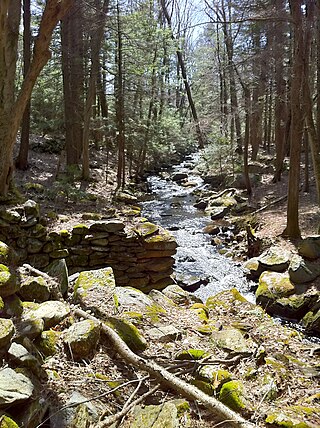
Mohawk State Forest, also known as Mohawk State Forest/Mohawk Mountain State Park, encompasses over 4,000 acres (1,600 ha) in the towns of Cornwall, Goshen, and Litchfield in the southern Berkshires of Litchfield County, Connecticut. As overseen by the Connecticut Department of Energy and Environmental Protection, the area is used for hiking, picnicking, and winter sports by the public, while being actively managed to produce timber and other forest products.
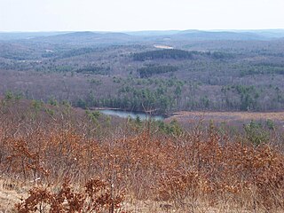
Pachaug State Forest is the largest forest in the Connecticut state forest system, encompassing over 27,000 acres (110 km²) of land. It is located on the Rhode Island border in New London County, and parcels of the forest lie in the towns of Voluntown, Griswold, Plainfield, Sterling, North Stonington, and Preston. The forest was founded in 1928, but most of the land came from purchases made later during the Great Depression. It is named after the Pachaug River, which runs through the center of the forest. The forest is part of the Northeastern coastal forests ecoregion.
Cockaponset State Forest is the second largest forest in the Connecticut state forest system, encompassing over 17,000 acres (6,900 ha) of land. Most of the land is in Middlesex County though some parcels lie in New Haven County. The forest is disjointed, and comprises land in the towns of Haddam, Chester, Deep River, Killingworth, Durham, Guilford, Madison, Clinton, Westbrook, Middletown and Middlefield.
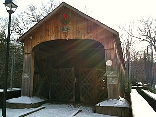
Salmon River State Forest is a Connecticut state forest located in the towns of Hebron, Marlborough, Colchester, East Haddam, and East Hampton. It includes 1,300 acres (530 ha) leased from the United States government. The forest features Comstock's Bridge, the only remaining covered bridge in eastern Connecticut, which spans the Salmon River near Route 16 in East Hampton.

Shenipsit State Forest is a state forest located in northeastern Connecticut with 11 parcels scattered between the towns of Somers, Ellington, and Stafford. The forest's headquarters is home to the Civilian Conservation Corps Museum, which houses memorabilia from CCC camps throughout the eastern United States. The forest is managed for forestry products and offers various recreational pursuits.

Nipmuck State Forest is a Connecticut state forest. Its 9,000 acres (3,600 ha) surround Bigelow Hollow State Park in the town of Union and include parcels in Stafford, Ashford, and other towns. The forest is part of a larger network of forest lands making up some 40,000 acres (16,000 ha) in all.
Natchaug State Forest is a Connecticut state forest located in six towns including Ashford, Chaplin, and Eastford. The Natchaug River runs from north to south along the western border of the main forest parcel. James L. Goodwin State Forest abuts Natchaug State Forest to the south. One of the forest units abuts Mashamoquet Brook State Park in Pomfret.

Granville State Forest is a Massachusetts state park located in the towns of Granville and Tolland in the southern Berkshire Hills along the state's southern border with Connecticut. The park is managed by the Department of Conservation and Recreation (DCR). It is adjacent to Connecticut's Tunxis State Forest.

The Tunxis Trail is a 79-mile (127 km) Blue-Blazed hiking trail "system" that traverses the western ridge of the central Connecticut Valley. The mainline trail is not completely contiguous, notably there are two gaps of several miles.
Naugatuck State Forest is a Connecticut state forest consisting of five separate blocks in the towns of Oxford, Beacon Falls, Naugatuck, Bethany, Cheshire, Hamden, Seymour, and Ansonia. The five blocks are the Mount Sanford, East, West, Quillinan Reservoir, and Great Hill (Seymour) blocks.

Satan's Kingdom State Recreation Area is a public recreation area occupying one-acre of land beside the Farmington River in the town of New Hartford, Connecticut. The site is located on the north side of the Route 44 bridge over the Farmington River. It is used as a put-in for canoeing, kayaking, and tubing excursions on the river.

James L. Goodwin State Forest is a Connecticut state forest covering approximately 2,000 acres (810 ha) in the towns of Chaplin and Hampton. The lands became public property when James L. Goodwin donated the personal forest he had been developing since 1913 to the state in 1964.
Nathan Hale State Forest is a Connecticut state forest encompassing 1,455 acres (589 ha) in the towns of Coventry and Andover. The forest is managed to sustain a reliable source of forest products and renewable habitat for wildlife. The forest originated in 1946 through the bequest of George Dudley Seymour, which allowed the state to purchase 850 acres in the surrounds of the historic Nathan Hale Homestead. In addition to cultivated plantations, the forest includes a 200-acre natural area that is kept without management activity. A 57-acre (23 ha) parcel, Creaser Park, is leased to the Town of Coventry for recreational use. The park offers hiking trails, fishing, and a dog-friendly area. Recreational usage in the rest of the forest includes hiking, hunting and letterboxing.

American Legion State Forest is a Connecticut state forest that sits on the West Branch Farmington River opposite Peoples State Forest in the town of Barkhamsted.

Peoples State Forest is a Connecticut state forest occupying 3,059 acres (1,238 ha) along the West Branch Farmington River opposite American Legion State Forest in the town of Barkhamsted. It is managed for forest products, wildlife habitat, and recreational uses that include hiking, hunting, fishing, and snowmobiling.

Centennial Watershed State Forest is a Connecticut state forest of more than 15,000 acres with larger parcels located in the towns of Easton, Newtown, Redding, and Weston. Dozens of other properties are strung throughout much of Southwestern part of the state. In 2002, the lands were acquired from the Aquarion Water Company by the state in partnership with The Nature Conservancy. Those three entities continue to manage the property by committee. The forest was named in honor of the hundredth anniversary of the state forest system.

Nassahegon State Forest is a Connecticut state forest occupying 1,227 acres (497 ha) in the town of Burlington.The forest is managed for forestry and recreational purposes and is operated by the Connecticut Department of Energy and Environmental Protection.

Nehantic State Forest is a publicly owned forest and recreation area occupying two parcels, one in the town of Lyme and one in the towns of East Lyme and Salem, in the state of Connecticut. The forest, which totals 5,062 acres (2,049 ha), is the site of regular prescribed burns and timber-harvesting operations. Purchase of the land began in 1926, when it became the first state forest located in New London County. It is managed by the Connecticut Department of Energy and Environmental Protection.

Pootatuck State Forest is a Connecticut state forest located mainly in the town of New Fairfield with a small fraction in Sherman. Recreational activities include hiking, mountain biking, letterboxing, hunting, birdwatching, snowmobiling, and cross-country skiing. The main forest property borders on and can be accessed via trails from the adjacent Squantz Pond State Park.

Tunxis State Forest is a state forest located in the towns of Hartland, Barkhamsted, and Granby in Connecticut, United States. The forest surrounds Barkhamsted Reservoir and borders the Granville State Forest in Massachusetts. The forest is used for hiking, mountain biking, cross-country skiing, fishing, hunting, and letterboxing. Several trails cross the forest, including the northern end of the blue-blazed Tunxis Trail.


