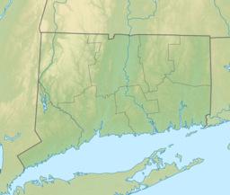
Easton is a town in Fairfield County, Connecticut, United States. The population was 7,605 at the time of the 2020 census. Easton contains the historic district of Aspetuck and the Plattsville census-designated place. Part of the Greater Bridgeport Planning Region, which is in turn a part of the New York metropolitan statistical area, it is bordered by the towns of Fairfield, Connecticut to the south, Redding to the north, Weston to the west, and Monroe and Trumbull to the east.
Monroe is a town located in eastern Fairfield County, Connecticut, United States. The population was 18,825 at the 2020 census. The town is part of the Greater Bridgeport Planning Region.

Redding is a town in Fairfield County, Connecticut, United States. The population was 8,765 at the 2020 census. The town is part of the Western Connecticut Planning Region.

The Saugatuck River is a 23.7-mile-long (38.1 km) river in southwestern Connecticut in the United States. It drains part of suburban and rural Fairfield County west of Bridgeport, emptying into Long Island Sound.

Route 58 is a primary state highway in the U.S. state of Connecticut connecting the towns of Fairfield and Bethel. Route 58 is 18.58 miles (29.90 km) long and is one of the primary routes to the downtown Danbury area via Routes 302 and 53.

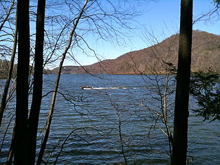
The Saugatuck Reservoir is a reservoir in Fairfield County, Connecticut, United States, that straddles the border between the towns of Redding, Weston, and Easton. Its completion is marked by the creation of the Samuel P. Senior dam of the Saugatuck River in January 1942, and provides water to several of the nearby towns. The reservoir is surrounded by the Centennial Watershed State Forest and a small section of the Trout Brook Valley State Park Reserve on the southeast end of the reservoir. The Saugatuck Reservoir utilizes an uncontrolled spillway adjacent to the Samuel P. Senior dam that effectively limits the maximum water level. There is also a concrete levee positioned on the southeastern side of the reservoir that prevents water from flooding Trout Brook Valley.
Aspetuck is a village, which in Connecticut is an unincorporated community on the Aspetuck River, in Fairfield County, Connecticut, mostly in the town of Easton but extending also into Weston. It is significant for being the location of the Aspectuck Historic District, a well-preserved collection of houses from the 18th and 19th centuries. The area was settled in the 17th century. It was a long-time home of Helen Keller. According to a New York Times real estate section article, "The district gets its name from the Aspetuck Indians, who lived along the river. In 1670, they sold the land to English settlers for cloth, winter wheat and maize valued at $.36." Weston was incorporated in 1787, and Easton was split out and incorporated in 1845.

The Mill River is a 16.3-mile (26.2 km) river in the town of Fairfield, Connecticut. It flows into Long Island Sound at Southport harbor.

The Aspetuck River is a 17.0-mile-long (27.4 km) river in the U.S. state of Connecticut. The river rises in the hills located in Huntington State Park in Bethel, with a watershed of approximately 430 acres (170 ha). The river flows generally southerly through Redding, Connecticut, to the Aspetuck Reservoir, the Hemlock Reservoir in Easton and Fairfield and finally into the Saugatuck River in Westport, Connecticut and then into the Long Island Sound. It flows through the village of Aspetuck at an average depth of 2.5 feet (0.76 m). The word Aspetuck can be translated as "river originating at the high place" in an Algonquian language.

The Pequonnock River is a 16.7-mile-long (26.9 km) waterway in eastern Fairfield County, Connecticut. Its watershed is located in five communities, with the majority of it located within Monroe, Trumbull, and Bridgeport. The river has a penchant for flooding, particularly in spring since the removal of a retention dam in Trumbull in the 1950s. There seems to be a sharp difference of opinion among historians as to just what the Indian word Pequonnock signifies. Some insist it meant cleared field or open ground; others are sure it meant broken ground; while a third group is certain it meant place of slaughter or place of destruction.

The Paugussett Trail is a 14-mile (23 km) Blue-Blazed hiking trail "system" in the lower Housatonic River valley in Fairfield County and, today, is entirely in Shelton and Monroe, Connecticut. Much of the trail is in Indian Well State Park and the Town of Monroe's Webb Mountain Park. The mainline trail is primarily southeast to northwest with three short side or spur trails.
The Lillinonah Trail is a 5.9-mile (9.5 km) Blue-Blazed hiking trail "system" in the lower Housatonic River valley in Fairfield County and, today, is entirely in Newtown. Most of the trail is in the upper block of Paugussett State Forest.
The Aspetuck Valley Trail is a 5.9-mile (9.5 km) Blue-Blazed hiking trail in the Aspetuck River Valley area of Fairfield County in the towns of Newtown, Easton and Redding Connecticut.

The Zoar Trail is a 6.5-mile (10.5 km) Blue-Blazed hiking trail "system" in the lower Housatonic River valley in Fairfield County and is entirely in the Sandy Hook section of Newtown in the lower block of Paugussett State Forest.
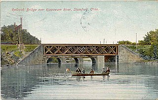
The Rippowam River is a river in Fairfield County, Connecticut and Westchester County, New York. It drains a watershed area of 37.5 square miles (97 km2) and flows for 17 miles (27 km) from Ridgefield to Long Island Sound, which it enters in Stamford's harbor.

The Aspetuck Land Trust is a nonprofit organization founded in 1967 that seeks to preserves open spaces in the towns of Westport, Fairfield, Weston and Easton in Fairfield County, Connecticut. In 2011 it was reported that the trust covered an area of 1,700 acres over 43 sites which include public trails.

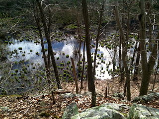
Trout Brook Valley State Park Reserve is a 300-acre (120 ha) parcel owned by the state of Connecticut that is part of the larger Trout Brook Valley Preserve, located in Easton, Connecticut. The full conservation area covers 1,009 acres (408 ha) and comprises several contiguous parcels in the towns of Easton and Weston, bordering the southeast corner of the Saugatuck Reservoir. It is managed by the Aspetuck Land Trust. The state park portion of the preserve offers opportunities for hiking and hunting.

Centennial Watershed State Forest is a Connecticut state forest of more than 15,000 acres with larger parcels located in the towns of Easton, Newtown, Redding, and Weston. Dozens of other properties are strung throughout much of Southwestern part of the state. In 2002, the lands were acquired from the Aquarion Water Company by the state in partnership with The Nature Conservancy. Those three entities continue to manage the property by committee. The forest was named in honor of the hundredth anniversary of the state forest system.

The Gold Coast, also known as Lower Fairfield County or Southwestern Connecticut not limited to the Connecticut panhandle, is an affluent part of Western Connecticut that includes the entire southern portion of Fairfield County as defined by the U.S. Census Bureau, Super-Public Use Microdata Area (Super-PUMA) Region 09600. The area is about 50 miles northeast of New York City, and is home to many wealthy Manhattan business executives. Parts of the region are served by the Western Connecticut Council of Governments.

Margerie Lake Reservoir is a 244 acre lake in New Fairfield, Connecticut. It is a source of drinking water for the Danbury area and is managed by the Danbury Water Department. It has a watershed of 2,942 acres.