Monroe is a town located in eastern Fairfield County, Connecticut, United States. The population was 18,825 at the 2020 census. The town is part of the Greater Bridgeport Planning Region.

Morrow Mountain State Park is a state park in Stanly County, North Carolina, U.S. Located near Albemarle, the park includes 5,881 acres (23.80 km2) within the Uwharrie Mountains.

Chatfield Hollow State Park is a public recreation area occupying 412 acres (167 ha) that lie adjacent to Cockaponset State Forest in the town of Killingworth, Connecticut. The state park offers hiking trails, a swimming beach, trout fishing, mountain biking, rock climbing, and picnicking areas. Park attractions include 6.67-acre (2.70 ha) Schreeder Pond, Indian caves, historic sites, a restored water wheel, and a reproduction covered bridge. The park is managed by the Connecticut Department of Energy and Environmental Protection.

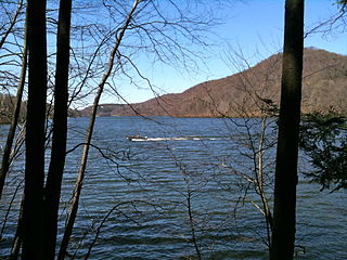
Squantz Pond State Park is a public recreation area located 10 miles (16 km) north of Danbury in the town of New Fairfield, Connecticut. The state park encompasses 172 acres (70 ha) on the southwestern shore of 270-acre (110 ha) Squantz Pond, offering opportunities for boating, swimming, fishing, and hiking. The park is bordered on the west by Pootatuck State Forest and is managed by the Connecticut Department of Energy and Environmental Protection.
Taconic State Park is located in Columbia and Dutchess County, New York abutting Massachusetts and Connecticut within the Taconic Mountains. The state park is located off New York State Route 344 south of Interstate 90 and 110 miles (180 km) north of New York City. It features camping, hiking, bicycling, hunting, cross county skiing and other recreational opportunities.

Prairie Creek Redwoods State Park is a state park, located in Humboldt County, California, near the town of Orick and 50 miles (80 km) north of Eureka. The 14,000 acre (57 km²) park is a coastal sanctuary for old-growth Coast Redwood trees.
Kings Gap Environmental Education Center is a 1,454-acre (588 ha) Pennsylvania state park in Cooke, Dickinson and Penn Townships, Cumberland County, Pennsylvania, in the United States. The Commonwealth of Pennsylvania acquired the land in 1973, from the C. H. Masland and Son Carpet Company. Kings Gap Environmental Education Center is 2.5 miles (4.0 km) from Pennsylvania Route 233 on South Mountain.

Prompton State Park is a Pennsylvania state park on 2,000 acres (809 ha) in Clinton and Dyberry Townships, Wayne County, Pennsylvania in the United States. This park, which was established in 1962, is officially listed by the Pennsylvania Department of Conservation and Natural Resources as being undeveloped. This means that it is officially a state park but the PA-DCNR is not currently managing the park. However, the lands of the park are open to visitors. Friends of Prompton State Park, a grassroots organization is working to take over management of the park in much the same way that Salt Springs State Park in Susquehanna County is managed by The Friends of Salt Springs Park. Northeast Sports Ltd. of Honesdale sponsors several outdoor sports events that are held at the park. Prompton State Park is 4.2 miles (6.8 km) west of Honesdale on Pennsylvania Route 170.
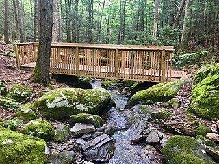
Webb Mountain Park is a 135-acre municipal park in Monroe, Connecticut, offering hiking trails, rock climbing, nature study, and campsites. The park backs up onto land where a historic castle building and residences for nuns are located. Webb Mountain Discovery Zone nature center with its own 170 acre park is adjacent. The park has diverse flora including numerous kinds of trees, shrubs, and ferns that not only add to the aesthetic value of the place but provide an ideal setting for some amateur as well as scientific study of the local plants. It is adjacent to the town-owned Webb Mountain Discovery Zone.
Ramsey Lake State Recreation Area is a 1,980-acre (800 ha) state park located in Fayette County, Illinois, United States. The nearest town is Ramsey, Illinois, and the park is adjacent to U.S. Highway 51. The park is managed by the Illinois Department of Natural Resources (IDNR).

West Rock Ridge or West Rock of south-central Connecticut, is a 7-mile (11 km) long trap rock mountain ridge located on the west side of New Haven with a high point of 700 feet (213 m). The ridge forms a continuous line of exposed cliffs visible from metropolitan New Haven and points west. West Rock Ridge is part of the narrow, linear Metacomet Ridge which extends from Long Island Sound near New Haven north through the Connecticut River Valley of Massachusetts to the Vermont border.
Mountain Lake Wilderness is a U.S. Wilderness Area in the George Washington and Jefferson National Forests. The wilderness area is located next to privately owned Mountain Lake, and consists of 8,314 acres (3,365 ha) in Virginia and 2,721 acres (1,101 ha) in West Virginia.

Waterloo State Recreation Area is the third-largest park in Michigan, encompassing over 21,000 acres (85 km2) of forest, lakes and wetlands. Located in northeast Jackson County and parts of Washtenaw County, the park is the largest in the Lower Peninsula of Michigan and features 4 campgrounds, 11 lakes, a nature center, and over 50 miles (80 km) of trails - some for horses, bicycles, hiking and cross-country skiing. Waterloo SRA includes the Black Spruce Bog Natural Area, a National Natural Landmark and borders the 11,000-acre (45 km2) Pinckney Recreation Area on the east and the 950-acre (3.8 km2) Phyllis Haehnle Memorial Audubon Sanctuary to the west. The land preserved by the park is not all contiguous and numerous private landholdings and roads run through the park area. The area is characterized by moraines, kettle lakes, swamps and bogs left by retreating glaciers after the last ice age. The park was created by the federal government during the Great Depression and is long-term leased to the state.
Little Tom Mountain is a 73-acre (300,000 m2) nature preserve in Holyoke, Massachusetts and is managed by the Trustees of Reservations. The land was purchased in 2002 by a joint effort of the Trustees of Reservations, U.S. Fish and Wildlife Service, the Department of Conservation and Recreation, and the Holyoke Boys & Girls Club from the holders of the former Mt. Tom Ski area. The Trustees and the Holyoke Boys and Girls Club have a cooperative management approach of the area and run an environmental education program together.

Moose Hill Wildlife Sanctuary is a 1,971 acres (798 ha) wildlife sanctuary located in Sharon, Massachusetts. The property is the oldest property of the Massachusetts Audubon Society, established in 1916. It is adjacent to Moose Hill Farm, which is owned by the Trustees of Reservations.

Federation Forest State Park is a 619-acre (251 ha) Washington state park on the White River in King County. The park is located 15 miles (24 km) east of Enumclaw on Route 410 about 30 miles (48 km) below the summit of Chinook Pass. The park features an old-growth forest that includes Douglas fir, western hemlock, Sitka spruce, and western redcedar trees. Park amenities include 7 miles (11 km) of hiking trails, picnicking facilities, and an interpretive center.

The Pequonnock River is a 16.7-mile-long (26.9 km) waterway in eastern Fairfield County, Connecticut. Its watershed is located in five communities, with the majority of it located within Monroe, Trumbull, and Bridgeport. The river has a penchant for flooding, particularly in spring since the removal of a retention dam in Trumbull in the 1950s. There seems to be a sharp difference of opinion among historians as to just what the Indian word Pequonnock signifies. Some insist it meant cleared field or open ground; others are sure it meant broken ground; while a third group is certain it meant place of slaughter or place of destruction.

The Paugussett Trail is a 14-mile (23 km) Blue-Blazed hiking trail "system" in the lower Housatonic River valley in Fairfield County and, today, is entirely in Shelton and Monroe, Connecticut. Much of the trail is in Indian Well State Park and the Town of Monroe's Webb Mountain Park. The mainline trail is primarily southeast to northwest with three short side or spur trails.