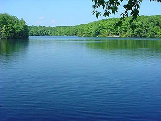
Millers Pond State Park is a public recreation area lying adjacent to Cockaponset State Forest in the towns of Durham and Haddam, Connecticut. The park's central feature is 33-acre (13 ha) Millers Pond, whose principal source of water is large springs that create a body of unpolluted water excellent for trout and smallmouth bass. The park offers fishing, hiking, mountain biking, and hunting.

Bigelow Hollow State Park is public recreation area in the town of Union, Connecticut, in the Quinebaug Highlands. The state park's 516 acres (209 ha) border Nipmuck State Forest on the east and west and Mashapaug Lake on the north. The park and forest are located in a large hollow or depression approximately 700' below the surrounding ridgelines. They are managed by the Connecticut Department of Energy and Environmental Protection.

Osbornedale State Park is a public recreation area occupying 417 acres (169 ha) on the east bank of the Housatonic River primarily in the town of Derby, Connecticut, with a small portion in Ansonia. The state park includes the historic Osborne Homestead, the Kellogg Environmental Center, and an extensive system of hiking trails. The park is managed by the Connecticut Department of Energy and Environmental Protection.

Beaver Brook State Park is an undeveloped public recreation area covering 401 acres (162 ha) in the towns of Windham and Chaplin, Connecticut. The state park encompasses Bibbins Pond, also known as Beaver Brook Pond, as well as the acreage northward as far as the Air Line State Park Trail, which forms the park's northern boundary. The park is a walk-in facility, open for hunting and trout fishing, managed by the Connecticut Department of Energy and Environmental Protection.

Quaddick State Park is a public recreation area located on 203-acre (82 ha) Middle Quaddick Reservoir in the town of Thompson, Connecticut. The state park is managed by the Connecticut Department of Energy and Environmental Protection and offers opportunities for boating, swimming, fishing, and picnicking.

Platt Hill State Park is an undeveloped public recreation area occupying 159 acres (64 ha) in the town of Winchester, Connecticut. The state park has hiking trails, picnicking sites, and views of the surrounding area.

Kettletown State Park is a public recreation area on the eastern shore of the Housatonic River's Lake Zoar in the towns of Oxford and Southbury, Connecticut. Park activities include camping, hiking, picnicking, and fishing. The state park is managed by the Connecticut Department of Energy and Environmental Protection.
Hopemead State Park is an undeveloped public recreation area on the eastern shore of Gardner Lake, 8 miles (13 km) west of Norwich, Connecticut. The state park covers 60 acres (24 ha) in the towns of Bozrah and Montville and is managed by the Connecticut Department of Energy and Environmental Protection.

Becket Hill State Park Reserve is a public recreation area lying adjacent to Nehantic State Forest in the town of Lyme, Connecticut. The state park is as an undeveloped, walk-in park totaling 260 acres (110 ha) with no officially listed activities. It is managed by the Connecticut Department of Energy and Environmental Protection.

Hurd State Park is a public recreation area lying adjacent to George Dudley Seymour State Park on the east bank of the Connecticut River in the town of East Hampton, Connecticut. In addition to offering hiking, picnicking, and mountain biking, it is one of four Connecticut state parks that offer primitive camping for boaters on the Connecticut River.
George Dudley Seymour State Park is a public recreation area occupying 222 acres (90 ha) on the east bank of the Connecticut River in the town of Haddam, Connecticut. Hurd State Park abuts the park to the north. The park bears the name of George Dudley Seymour (1859-1945), whose philanthropic efforts enabled the state to purchase land for this and several other Connecticut state parks. It is managed by the Connecticut Department of Energy and Environmental Protection.

Haddam Meadows State Park is a public recreation area occupying 175 acres (71 ha) on the west bank of the Connecticut River in the town of Haddam, Connecticut. The state park offers picnicking, fishing, and a boat launch. Park trails lend access to a diversity of riverside landscapes: marsh, beach, sand bar, fern growths, meadow lands, and hardwood forest. The park was established through the donation of land in 1944 by the Edward W. Hazen Foundation. It is managed by the Connecticut Department of Energy and Environmental Protection.
Stoddard Hill State Park is a public recreation area located on the eastern shore of the Thames River, about five miles (8.0 km) south of Norwich, in the town of Ledyard, Connecticut. The state park covers 55 acres and offers facilities for boating, fishing, and hiking. It is managed by the Connecticut Department of Energy and Environmental Protection.

James L. Goodwin State Forest is a Connecticut state forest covering approximately 2,000 acres (810 ha) in the towns of Chaplin and Hampton. The lands became public property when James L. Goodwin donated the personal forest he had been developing since 1913 to the state in 1964.
Nathan Hale State Forest is a Connecticut state forest encompassing 1,455 acres (589 ha) in the towns of Coventry and Andover. The forest is managed to sustain a reliable source of forest products and renewable habitat for wildlife. The forest originated in 1946 through the bequest of George Dudley Seymour, which allowed the state to purchase 850 acres in the surrounds of the historic Nathan Hale Homestead. In addition to cultivated plantations, the forest includes a 200-acre natural area that is kept without management activity. A 57-acre (23 ha) parcel, Creaser Park, is leased to the Town of Coventry for recreational use. The park offers hiking trails, fishing, and a dog-friendly area. Recreational usage in the rest of the forest includes hiking, hunting and letterboxing.
Massacoe State Forest is a Connecticut state forest located in the town of Simsbury. The forest comprises two noncontiguous sections: the Great Pond Block, which encompasses 36-acre (15 ha) Great Pond, and the Massacoe Block, which lies next to Stratton Brook State Park. Forest recreational activities include hiking, fishing, and bird watching.

Nassahegon State Forest is a Connecticut state forest occupying 1,227 acres (497 ha) in the town of Burlington.The forest is managed for forestry and recreational purposes and is operated by the Connecticut Department of Energy and Environmental Protection.

Nehantic State Forest is a publicly owned forest and recreation area occupying two parcels, one in the town of Lyme and one in the towns of East Lyme and Salem, in the state of Connecticut. The forest, which totals 5,062 acres (2,049 ha), is the site of regular prescribed burns and timber-harvesting operations. Purchase of the land began in 1926, when it became the first state forest located in New London County. It is managed by the Connecticut Department of Energy and Environmental Protection.

Paugnut State Forest is a Connecticut state forest located on four parcels in the towns of Torrington and Winchester. The forest's Arts and Crafts–style administration building was constructed by the Civilian Conservation Corps in 1937 and has been listed on the National Register of Historic Places. The remains of the foundation of the condensed milk factory established by Gail Borden on Burr Pond in 1857 may also be seen. Trails crossing the forest include the John Muir Trail which connects Burr Pond State Park and Sunnybrook State Park.

Paugussett State Forest is a Connecticut state forest with two separate sections located on impoundments of the Housatonic River in the town of Newtown. The forest's Upper Block encompasses approximately 800 acres (320 ha) on the western shore of Lake Lillinonah. It offers boating access to the river and hiking on the blue-blazed Lillinonah Trail. The forest's Lower Block encompasses approximately 1,200 acres (490 ha) on the western shore of Lake Zoar and offers hiking on the blue-blazed Zoar Trail.

