
Pachaug State Forest is the largest forest in the Connecticut state forest system, encompassing over 27,000 acres (110 km²) of land. It is located on the Rhode Island border in New London County, and parcels of the forest lie in the towns of Voluntown, Griswold, Plainfield, Sterling, North Stonington, and Preston. The forest was founded in 1928, but most of the land came from purchases made later during the Great Depression. It is named after the Pachaug River, which runs through the center of the forest. The forest is part of the Northeastern coastal forests ecoregion.

Cockaponset State Forest is the second largest forest in the Connecticut state forest system, encompassing over 17,000 acres (6,900 ha) of land. Most of the land is in Middlesex County though some parcels lie in New Haven County. The forest is disjointed, and comprises land in the towns of Haddam, Chester, Deep River, Killingworth, Durham, Guilford, Madison, Clinton, Westbrook, Middletown and Middlefield.

Wadsworth Falls State Park, or simply Wadsworth Falls, is a public recreation and preserved natural area located on the Coginchaug River in the towns of Middletown and Middlefield, Connecticut. The state park's 285 acres (115 ha) offer trail hiking and fishing. Swimming, picnicking, and alcohol are no longer allowed. It is managed by the Connecticut Department of Energy and Environmental Protection.

The Salmon River is formed at the confluence of the Blackledge and Jeremy rivers about one mile west of North Westchester, Connecticut. It drains 96,000 acres and courses for 10.4 miles (16.7 km) to Salmon Cove near Moodus where it flows into the Connecticut River. The Salmon River is probably the largest stream and watershed whose sources and mouth are entirely within the limits of Connecticut.

Mattatuck State Forest is a Connecticut state forest spread over twenty parcels in the towns of Waterbury, Plymouth, Thomaston, Watertown, Litchfield, and Harwinton. The Naugatuck River runs through a portion of the forest. The largest section of the forest is located about 1 mile (1.6 km) north of Waterbury. The Leatherman's Cave, named after the vagabond Leatherman of the late 19th century, is located in Thomaston on the Mattatuck Trail, just north of the junction with the Jericho Trail.
Wharton Brook State Park is a public recreation area located off U.S. Route 5 in the towns of North Haven and Wallingford, Connecticut. Activities in the 96-acre (39 ha) state park center on Allen Brook Pond, a 5-acre (2.0 ha) pond that empties into Wharton Brook. The park is managed by the Connecticut Department of Energy and Environmental Protection.

Quinebaug Lake State Park is a public recreation area covering 181 acres (73 ha) in the town of Killingly, Connecticut. The state park offers opportunities for fishing and non-motorized boating on Wauregan Reservoir. The park is managed by the Connecticut Department of Energy and Environmental Protection.
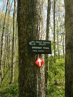
Trout Brook Valley State Park Reserve is a 300-acre (120 ha) parcel owned by the state of Connecticut that is part of the larger Trout Brook Valley Preserve, located in Easton, Connecticut. The full conservation area covers 1,009 acres (408 ha) and comprises several contiguous parcels in the towns of Easton and Weston, bordering the southeast corner of the Saugatuck Reservoir. It is managed by the Aspetuck Land Trust. The state park portion of the preserve offers opportunities for hiking and hunting.
James L. Goodwin State Forest is a Connecticut state forest covering approximately 2,000 acres (810 ha) in the towns of Chaplin and Hampton. The lands became public property when James L. Goodwin donated the personal forest he had been developing since 1913 to the state in 1964.
Nathan Hale State Forest is a Connecticut state forest encompassing 1,455 acres (589 ha) in the towns of Coventry and Andover. The forest is managed to sustain a reliable source of forest products and renewable habitat for wildlife. The forest originated in 1946 through the bequest of George Dudley Seymour, which allowed the state to purchase 850 acres in the surrounds of the historic Nathan Hale Homestead. In addition to cultivated plantations, the forest includes a 200-acre natural area that is kept without management activity. A 57-acre (23 ha) parcel, Creaser Park, is leased to the Town of Coventry for recreational use. The park offers hiking trails, fishing, and a dog-friendly area. Recreational usage in the rest of the forest includes hiking, hunting and letterboxing.

Peoples State Forest is a Connecticut state forest occupying 3,059 acres (1,238 ha) along the West Branch Farmington River opposite American Legion State Forest in the town of Barkhamsted. It is managed for forest products, wildlife habitat, and recreational uses that include hiking, hunting, fishing, and snowmobiling.

Centennial Watershed State Forest is a Connecticut state forest of more than 15,000 acres with larger parcels located in the towns of Easton, Newtown, Redding, and Weston. Dozens of other properties are strung throughout much of Southwestern part of the state. In 2002, the lands were acquired from the Aquarion Water Company by the state in partnership with The Nature Conservancy. Those three entities continue to manage the property by committee. The forest was named in honor of the hundredth anniversary of the state forest system.

Housatonic State Forest is a Connecticut state forest occupying 10,894 acres (4,409 ha) in the towns of Sharon, Canaan, Cornwall, and North Canaan. The state forest includes two Connecticut natural area preserves, Gold’s Pines and Canaan Mountain, and is the only Connecticut state forest that includes a portion of the Appalachian Trail. The forest is open for hiking, hunting, mountain biking, and snowmobiling.
Massacoe State Forest is a Connecticut state forest located in the town of Simsbury. The forest comprises two noncontiguous sections: the Great Pond Block, which encompasses 36-acre (15 ha) Great Pond, and the Massacoe Block, which lies next to Stratton Brook State Park. Forest recreational activities include hiking, fishing, and bird watching.

Nehantic State Forest is a publicly owned forest and recreation area occupying two parcels, one in the town of Lyme and one in the towns of East Lyme and Salem, in the state of Connecticut. The forest, which totals 5,062 acres (2,049 ha), is the site of regular prescribed burns and timber-harvesting operations. Purchase of the land began in 1926, when it became the first state forest located in New London County. It is managed by the Connecticut Department of Energy and Environmental Protection.

Nepaug State Forest is a Connecticut state forest located primarily in the town of New Hartford.
Paugnut State Forest is a Connecticut state forest located on four parcels in the towns of Torrington and Winchester. The forest's Arts and Crafts–style administration building was constructed by the Civilian Conservation Corps in 1937 and has been listed on the National Register of Historic Places. The remains of the foundation of the condensed milk factory established by Gail Borden on Burr Pond in 1857 may also be seen. Trails crossing the forest include the John Muir Trail which connects Burr Pond State Park and Sunnybrook State Park.

Pootatuck State Forest is a Connecticut state forest located mainly in the town of New Fairfield with a small fraction in Sherman. Recreational activities include hiking, mountain biking, letterboxing, hunting, birdwatching, snowmobiling, and cross-country skiing. The main forest property borders on and can be accessed via trails from the adjacent Squantz Pond State Park.
Quaddick State Forest is a Connecticut state forest located in the town of Thompson north of Quaddick State Park. The forest protects 466-acre (189 ha) Quaddick Reservoir and provides opportunities for fishing, hunting, canoeing, letterboxing, and youth group camping.

Tunxis State Forest is a Connecticut state forest located in the towns of Hartland, Barkhamsted, and Granby. The forest surrounds Barkhamsted Reservoir and borders the Granville State Forest in Massachusetts. The forest is used for hiking, mountain biking, cross-country skiing, fishing, hunting, and letterboxing. Several trails cross the forest, including the northern end of the blue-blazed Tunxis Trail.
