
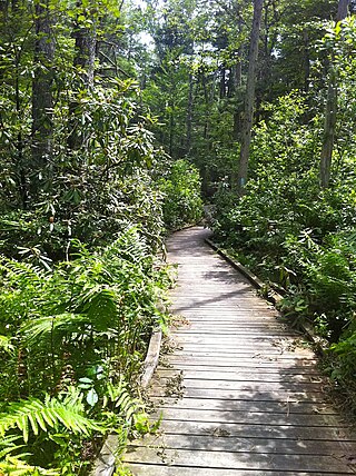
Chatfield Hollow State Park is a public recreation area occupying 412 acres (167 ha) that lie adjacent to Cockaponset State Forest in the town of Killingworth, Connecticut. The state park offers hiking trails, a swimming beach, trout fishing, mountain biking, rock climbing, and picnicking areas. Park attractions include 6.67-acre (2.70 ha) Schreeder Pond, Indian caves, historic sites, a restored water wheel, and a reproduction covered bridge. The park is managed by the Connecticut Department of Energy and Environmental Protection.
Pachaug State Forest is the largest forest in the Connecticut state forest system, encompassing over 27,000 acres (110 km²) of land. It is located on the Rhode Island border in New London County, and parcels of the forest lie in the towns of Voluntown, Griswold, Plainfield, Sterling, North Stonington, and Preston. The forest was founded in 1928, but most of the land came from purchases made later during the Great Depression. It is named after the Pachaug River, which runs through the center of the forest. The forest is part of the Northeastern coastal forests ecoregion.
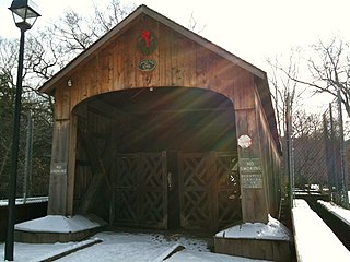
Salmon River State Forest is a Connecticut state forest located in the towns of Hebron, Marlborough, Colchester, East Haddam, and East Hampton. It includes 1,300 acres (530 ha) leased from the United States government. The forest features Comstock's Bridge, the only remaining covered bridge in eastern Connecticut, which spans the Salmon River near Route 16 in East Hampton.

Mattatuck State Forest is a Connecticut state forest spread over twenty parcels in the towns of Waterbury, Plymouth, Thomaston, Watertown, Litchfield, and Harwinton. The Naugatuck River runs through a portion of the forest. The largest section of the forest is located about 1 mile (1.6 km) north of Waterbury. The Leatherman's Cave, named after the vagabond Leatherman of the late 19th century, is located in Thomaston near the Mattatuck Trail, 1/4 mile west of the junction with the Jericho Trail.

Indian Well State Park is a public recreation area occupying 153 acres (62 ha) on the west bank of Lake Housatonic, an impoundment of the Housatonic River, within the city limits of Shelton, Connecticut. The state park's scenic features include a 15-foot (4.6 m) horsetail waterfalls with splash pool at bottom. The park is managed by the Connecticut Department of Energy and Environmental Protection.

Shenipsit State Forest is a state forest located in northeastern Connecticut with 11 parcels scattered between the towns of Somers, Ellington, and Stafford. The forest's headquarters is home to the Civilian Conservation Corps Museum, which houses memorabilia from CCC camps throughout the eastern United States. The forest is managed for forestry products and offers various recreational pursuits.
Natchaug State Forest is a Connecticut state forest located in six towns including Ashford, Chaplin, and Eastford. The Natchaug River runs from north to south along the western border of the main forest parcel. James L. Goodwin State Forest abuts Natchaug State Forest to the south. One of the forest units abuts Mashamoquet Brook State Park in Pomfret.

Osbornedale State Park is a public recreation area occupying 417 acres (169 ha) on the east bank of the Housatonic River primarily in the town of Derby, Connecticut, with a small portion in Ansonia. The state park includes the historic Osborne Homestead, the Kellogg Environmental Center, and an extensive system of hiking trails. The park is managed by the Connecticut Department of Energy and Environmental Protection.
Naugatuck State Forest is a Connecticut state forest consisting of five separate blocks in the towns of Oxford, Beacon Falls, Naugatuck, Bethany, Cheshire, Hamden, Seymour, and Ansonia. The five blocks are the Mount Sanford, East, West, Quillinan Reservoir, and Great Hill (Seymour) blocks.

Quinnipiac River State Park is a public recreation area located in the town of North Haven, Connecticut. The four sections of the state park protect 6 miles (9.7 km) of the Quinnipiac River.

Satan's Kingdom State Recreation Area is a public recreation area occupying one-acre of land beside the Farmington River in the town of New Hartford, Connecticut. The site is located on the north side of the Route 44 bridge over the Farmington River. It is used as a put-in for canoeing, kayaking, and tubing excursions on the river.
Rocky Glen State Park is an undeveloped public recreation area covering 46 acres (19 ha) along the west side of the Pootatuck River in the town of Newtown, Connecticut. The state park offers opportunities for hiking to a scenic cascade and includes a one-and-a-half mile stretch of Al's Trail, a 10.7-mile (17.2 km) greenway trail that winds through Newtown. It appeared as the state's forty-seventh state park in the 1943 edition of the Connecticut Register and Manual. The park is managed by the Connecticut Department of Energy and Environmental Protection.

Farmington Canal State Park Trail is a Connecticut state park forming a portion of the Farmington Canal Heritage Trail in the towns of Cheshire and Hamden. The developed section of the trail within state park boundaries runs over 17.0 miles (27.4 km) from Lazy Lane in Southington to Todd Street in Hamden and includes the historic Farmington Canal's restored Lock 12, located south of Brooksvale Road in Cheshire. The paved, multiple-use trail is used for hiking, biking, jogging, in-line skating and cross-country skiing.
Stoddard Hill State Park is a public recreation area located on the eastern shore of the Thames River, about five miles (8.0 km) south of Norwich, in the town of Ledyard, Connecticut. The state park covers 55 acres and offers facilities for boating, fishing, and hiking. It is managed by the Connecticut Department of Energy and Environmental Protection.

James L. Goodwin State Forest is a Connecticut state forest covering approximately 2,000 acres (810 ha) in the towns of Chaplin and Hampton. The lands became public property when James L. Goodwin donated the personal forest he had been developing since 1913 to the state in 1964.

Peoples State Forest is a Connecticut state forest occupying 3,059 acres (1,238 ha) along the West Branch Farmington River opposite American Legion State Forest in the town of Barkhamsted. It is managed for forest products, wildlife habitat, and recreational uses that include hiking, hunting, fishing, and snowmobiling.

Nassahegon State Forest is a Connecticut state forest occupying 1,227 acres (497 ha) in the town of Burlington.The forest is managed for forestry and recreational purposes and is operated by the Connecticut Department of Energy and Environmental Protection.

Nehantic State Forest is a publicly owned forest and recreation area occupying two parcels, one in the town of Lyme and one in the towns of East Lyme and Salem, in the state of Connecticut. The forest, which totals 5,062 acres (2,049 ha), is the site of regular prescribed burns and timber-harvesting operations. Purchase of the land began in 1926, when it became the first state forest located in New London County. It is managed by the Connecticut Department of Energy and Environmental Protection.

Nepaug State Forest is a Connecticut state forest located primarily in the town of New Hartford.

Paugussett State Forest is a Connecticut state forest with two separate sections located on impoundments of the Housatonic River in the town of Newtown. The forest's Upper Block encompasses approximately 800 acres (320 ha) on the western shore of Lake Lillinonah. It offers boating access to the river and hiking on the blue-blazed Lillinonah Trail. The forest's Lower Block encompasses approximately 1,200 acres (490 ha) on the western shore of Lake Zoar and offers hiking on the blue-blazed Zoar Trail.


