
Chatfield Hollow State Park is a public recreation area occupying 412 acres (167 ha) that lie adjacent to Cockaponset State Forest in the town of Killingworth, Connecticut. The state park offers hiking trails, a swimming beach, trout fishing, mountain biking, rock climbing, and picnicking areas. Park attractions include 6.67-acre (2.70 ha) Schreeder Pond, Indian caves, historic sites, a restored water wheel, and a reproduction covered bridge. The park is managed by the Connecticut Department of Energy and Environmental Protection.
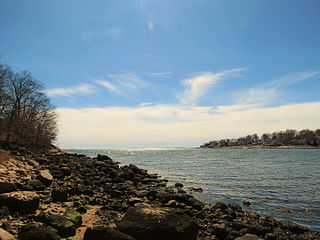
Rocky Neck State Park is a public recreation area on Long Island Sound in the town of East Lyme, Connecticut, United States. The state park's 708 acres (287 ha) include a tidal river, a broad salt marsh, white sand beaches, rocky shores, and a large stone pavilion dating from the 1930s. It is managed by the Connecticut Department of Energy and Environmental Protection.

Harkness Memorial State Park is a historic preservation area with botanical garden and recreational features located on Long Island Sound in the town of Waterford, Connecticut. The state park's 304 acres (123 ha) center around Eolia, a 42-room Renaissance Revival mansion with formal gardens and greenhouses. The park is managed by the Connecticut Department of Energy and Environmental Protection.
Mohawk State Forest, also known as Mohawk State Forest/Mohawk Mountain State Park, encompasses over 4,000 acres (1,600 ha) in the towns of Cornwall, Goshen, and Litchfield in the southern Berkshires of Litchfield County, Connecticut. As overseen by the Connecticut Department of Energy and Environmental Protection, the area is used for hiking, picnicking, and winter sports by the public, while being actively managed to produce timber and other forest products.
Pachaug State Forest is the largest forest in the Connecticut state forest system, encompassing over 27,000 acres (110 km²) of land. It is located on the Rhode Island border in New London County, and parcels of the forest lie in the towns of Voluntown, Griswold, Plainfield, Sterling, North Stonington, and Preston. The forest was founded in 1928, but most of the land came from purchases made later during the Great Depression. It is named after the Pachaug River, which runs through the center of the forest. The forest is part of the Northeastern coastal forests ecoregion.
Cockaponset State Forest is the second largest forest in the Connecticut state forest system, encompassing over 17,000 acres (6,900 ha) of land. Most of the land is in Middlesex County though some parcels lie in New Haven County. The forest is disjointed, and comprises land in the towns of Haddam, Chester, Deep River, Killingworth, Durham, Guilford, Madison, Clinton, Westbrook, Middletown and Middlefield.

Wadsworth Falls State Park, or simply Wadsworth Falls, is a public recreation and preserved natural area located on the Coginchaug River in the towns of Middletown and Middlefield, Connecticut. The state park's 285 acres (115 ha) offer trail hiking and fishing. Swimming and picnicking are allowed at the pond near the north entrance near 721 Wadsworth Street in Middletown. It is managed by the Connecticut Department of Energy and Environmental Protection.

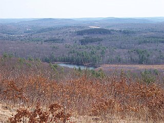
Mansfield Hollow Lake is a reservoir resting on the border of Windham County and Tolland County, Connecticut. The reservoir provides drinking water for Willimantic and helps control flooding in the 159-square-mile Thames River watershed. It was created by the Mansfield Hollow Dam and is entirely contained within Mansfield Hollow State Park and the Mansfield Hollow Wildlife Area. Designed and constructed by the United States Army Corps of Engineers, the dam substantially reduces flooding along the Quinebaug, Shetucket, and Thames rivers. Construction of the project began in 1949 with completion in 1952 at a cost of US$6.5 million. The Mansfield Hollow reservoir is located within the Shetucket River Watershed and is part of the Thames River Basin. Access to the site is available from US Route 6 and State Route 195. The damsite, covering an area of 25 acres (10 ha), was listed on the National Register of Historic Places in 2003.

Shenipsit State Forest is a state forest located in northeastern Connecticut with 11 parcels scattered between the towns of Somers, Ellington, and Stafford. The forest's headquarters is home to the Civilian Conservation Corps Museum, which houses memorabilia from CCC camps throughout the eastern United States. The forest is managed for forestry products and offers various recreational pursuits.

Mount Tom State Park is a public recreation area lying south of US Route 202 in the towns of Washington, Litchfield, and Morris, Connecticut. The state park occupies 231 acres (93 ha) on the southwest shore of Mount Tom Pond and is home to the Mount Tom Tower, which was listed on the National Register of Historic Places in 1993. It is managed by the Connecticut Department of Energy and Environmental Protection.

Osbornedale State Park is a public recreation area occupying 417 acres (169 ha) on the east bank of the Housatonic River primarily in the town of Derby, Connecticut, with a small portion in Ansonia. The state park includes the historic Osborne Homestead, the Kellogg Environmental Center, and an extensive system of hiking trails. The park is managed by the Connecticut Department of Energy and Environmental Protection.

Topsmead State Forest is a Connecticut state forest located in the town of Litchfield. It was formerly the summer residence of Edith Morton Chase, daughter of Henry Sabin Chase, first president of the Chase Brass and Copper Company. She left the house and its grounds to the state of Connecticut on her death in 1972. The estate house, built in 1929 to a design by Richard Henry Dana, is a fine example of a Tudor Revival country estate house, and is listed on the National Register of Historic Places.
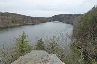
Lovers Leap State Park is a public recreation area on the Housatonic River in the town of New Milford, Litchfield County, Connecticut. The state park's 127 acres (51 ha) straddle the Housatonic Gorge near the intersection of Connecticut Route 67 and Connecticut Route 202. The park offers hiking to scenic and historic locations and is managed by the Connecticut Department of Energy and Environmental Protection.
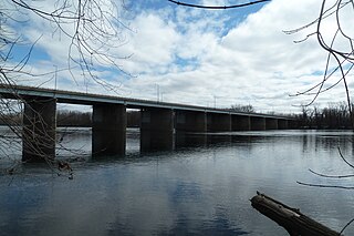
Windsor Meadows State Park is a public recreation area on the west side of the Connecticut River in the town of Windsor, Connecticut. The state park occupies three largely undeveloped sections measuring 48, 19, and 88 acres located between railroad tracks and the river. Park activities include picnicking, fishing, boating, hiking, and biking.

Above All State Park is an undeveloped public recreation area located in the town of Warren, Connecticut. Remnants of a Cold War-era military radar installation may be seen. The only park amenities are informal trails not maintained by the Connecticut Department of Energy and Environmental Protection.

Platt Hill State Park is an undeveloped public recreation area occupying 159 acres (64 ha) in the town of Winchester, Connecticut. The state park has hiking trails, picnicking sites, and views of the surrounding area.
Hopemead State Park is an undeveloped public recreation area on the eastern shore of Gardner Lake, 8 miles (13 km) west of Norwich, Connecticut. The state park covers 60 acres (24 ha) in the towns of Bozrah and Montville and is managed by the Connecticut Department of Energy and Environmental Protection.
Pomeroy State Park is an undeveloped public recreation area covering 200 acres (81 ha) just south of Willimantic in the town of Lebanon, Connecticut. The state park is a forested area used for hiking and hunting with no entrance, markings, or parking that abuts preserved farmland. It is under the management of the Connecticut Department of Energy and Environmental Protection.

Becket Hill State Park Reserve is a public recreation area lying adjacent to Nehantic State Forest in the town of Lyme, Connecticut. The state park is as an undeveloped, walk-in park totaling 260 acres (110 ha) with no officially listed activities. It is managed by the Connecticut Department of Energy and Environmental Protection.

Nehantic State Forest is a publicly owned forest and recreation area occupying two parcels, one in the town of Lyme and one in the towns of East Lyme and Salem, in the state of Connecticut. The forest, which totals 5,062 acres (2,049 ha), is the site of regular prescribed burns and timber-harvesting operations. Purchase of the land began in 1926, when it became the first state forest located in New London County. It is managed by the Connecticut Department of Energy and Environmental Protection.


