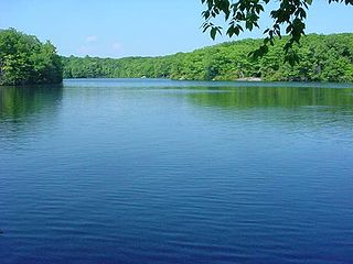
Millers Pond State Park is a public recreation area lying adjacent to Cockaponset State Forest in the towns of Durham and Haddam, Connecticut. The park's central feature is 33-acre (13 ha) Millers Pond, whose principal source of water is large springs that create a body of unpolluted water excellent for trout and smallmouth bass. The park offers fishing, hiking, mountain biking, and hunting.

Black Rock State Park is a seasonal public recreation area adjoining Mattatuck State Forest in the town of Watertown, Connecticut. The state park covers 444 acres (180 ha) and is known for its large rock face, Black Rock, that offers views of Thomaston, Watertown, and portions of Waterbury. The park is managed by the Connecticut Department of Energy and Environmental Protection.

Bigelow Hollow State Park is public recreation area in the town of Union, Connecticut, in the Quinebaug Highlands. The state park's 516 acres (209 ha) border Nipmuck State Forest on the east and west and Mashapaug Lake on the north. The park and forest are located in a large hollow or depression approximately 700' below the surrounding ridgelines. They are managed by the Connecticut Department of Energy and Environmental Protection.

Indian Well State Park is a public recreation area occupying 153 acres (62 ha) on the west bank of Lake Housatonic, an impoundment of the Housatonic River, within the city limits of Shelton, Connecticut. The state park's scenic features include a 15-foot (4.6 m) horsetail waterfalls with splash pool at bottom. The park is managed by the Connecticut Department of Energy and Environmental Protection.
Wharton Brook State Park is a public recreation area located off U.S. Route 5 in the towns of North Haven and Wallingford, Connecticut. Activities in the 96-acre (39 ha) state park center on Allen Brook Pond, a 5-acre (2.0 ha) pond that empties into Wharton Brook. The park is managed by the Connecticut Department of Energy and Environmental Protection.

Burr Pond State Park is a public recreation area covering 438 acres (177 ha) adjacent to Paugnut State Forest in the town of Torrington, Connecticut. The state park surrounds Burr Pond, an 85-acre (34 ha), man-made body of water with facilities for swimming, boating, and fishing. It is managed by the Connecticut Department of Energy and Environmental Protection.

Mansfield Hollow State Park is a public recreation area occupying 251 acres (102 ha) of leased lands on the western shore of 500-acre (200 ha) Mansfield Hollow Lake in the town of Mansfield, Connecticut. The state park is one portion of the 2,300 acres (930 ha) leased by the Connecticut Department of Energy and Environmental Protection from the U.S. Army Corps of Engineers for recreational and wildlife management purposes. Geologic features of the park include remnants of the last glacial period, where retreating glaciers left kames, eskers, and kettles. Recreational opportunities include facilities for boating, fishing, picnicking, hiking, mountain biking, and cross-country skiing. The park is traversed by the southeastern leg of the Nipmuck Trail.
Mono Pond State Park Reserve is a public recreation area covering 218 acres (88 ha) in the town of Columbia, Connecticut, 8 miles (13 km) southwest of Willimantic. The state park surrounds Mono Pond, a 113-acre (46 ha) body of water averaging depths of 3.5 feet (1.1 m) with an area near the dam reaching a depth of nine feet (2.7 m). The park offers fishing, hiking, picnicking, cross-country skiing, bow hunting, and a boat launch for motorized and non-motorized boating. The park is managed by the Connecticut Department of Energy and Environmental Protection and was added to the roll of Connecticut state parks in 2008.

Quaddick State Park is a public recreation area located on 203-acre (82 ha) Middle Quaddick Reservoir in the town of Thompson, Connecticut. The state park is managed by the Connecticut Department of Energy and Environmental Protection and offers opportunities for boating, swimming, fishing, and picnicking.

Housatonic Meadows State Park is a public recreation area covering 452 acres (183 ha) along the Housatonic River in the towns of Sharon and Cornwall, Connecticut. The state park offers opportunities for camping, hiking, picnicking, canoeing, and fly-fishing. It is crossed by the Appalachian Trail and is managed by the Connecticut Department of Energy and Environmental Protection.
Stillwater Pond State Park is a public recreation area covering 226 acres (91 ha) in the town of Torrington, Connecticut. The state park surrounds Stillwater Pond, a 100-acre (40 ha) impoundment on the West Branch Naugatuck River. Fishing, boating, and a paved boat ramp are offered.

Larkin State Park Trail is a Connecticut rail trail that follows the former New York & New England Railroad roadbed across the towns of Southbury, Oxford, Middlebury, and Naugatuck. The trail is 10.3 miles (16.6 km) long; its eastern terminus is at Whittemore Glen State Park, the western at Kettletown Road in Southbury. The trail is open for hiking, biking, horseback riding, and cross-country skiing.
George Waldo State Park is an undeveloped public recreation area on the eastern shore of Lake Lillinonah in the town of Southbury, Connecticut. Park activities include hiking, mountain biking, horseback riding, fishing, and hunting. The state park is managed by the Connecticut Department of Energy and Environmental Protection.
Mooween State Park is a public recreation area covering 577 acres (234 ha) in the town of Lebanon, Connecticut. The state park offers hiking and mountain biking plus fishing and boating on 127-acre (51 ha) Red Cedar Lake.

Haddam Meadows State Park is a public recreation area occupying 175 acres (71 ha) on the west bank of the Connecticut River in the town of Haddam, Connecticut. The state park offers picnicking, fishing, and a boat launch. Park trails lend access to a diversity of riverside landscapes: marsh, beach, sand bar, fern growths, meadow lands, and hardwood forest. The park was established through the donation of land in 1944 by the Edward W. Hazen Foundation. It is managed by the Connecticut Department of Energy and Environmental Protection.
Stoddard Hill State Park is a public recreation area located on the eastern shore of the Thames River, about five miles (8.0 km) south of Norwich, in the town of Ledyard, Connecticut. The state park covers 55 acres and offers facilities for boating, fishing, and hiking. It is managed by the Connecticut Department of Energy and Environmental Protection.

James L. Goodwin State Forest is a Connecticut state forest covering approximately 2,000 acres (810 ha) in the towns of Chaplin and Hampton. The lands became public property when James L. Goodwin donated the personal forest he had been developing since 1913 to the state in 1964.

Housatonic State Forest is a Connecticut state forest occupying 10,894 acres (4,409 ha) in the towns of Sharon, Canaan, Cornwall, and North Canaan. The state forest includes two Connecticut natural area preserves, Gold’s Pines and Canaan Mountain, and is the only Connecticut state forest that includes a portion of the Appalachian Trail. The forest is open for hiking, hunting, mountain biking, and snowmobiling.

Nassahegon State Forest is a Connecticut state forest occupying 1,227 acres (497 ha) in the town of Burlington.The forest is managed for forestry and recreational purposes and is operated by the Connecticut Department of Energy and Environmental Protection.

Nehantic State Forest is a publicly owned forest and recreation area occupying two parcels, one in the town of Lyme and one in the towns of East Lyme and Salem, in the state of Connecticut. The forest, which totals 5,062 acres (2,049 ha), is the site of regular prescribed burns and timber-harvesting operations. Purchase of the land began in 1926, when it became the first state forest located in New London County. It is managed by the Connecticut Department of Energy and Environmental Protection.


